Related Research Articles
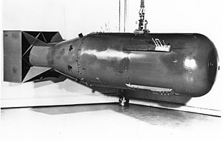
Nuclear weapons tests are experiments carried out to determine the effectiveness, yield, and explosive capability of nuclear weapons. Testing nuclear weapons offers practical information about how the weapons function, as well as how detonations are affected by different conditions; and how personnel, structures, and equipment are affected when subjected to nuclear explosions. However, nuclear testing has often been used as an indicator of scientific and military strength, and many tests have been overtly political in their intention; most nuclear weapons states publicly declared their nuclear status by means of a nuclear test.
The Kwangmyŏngsŏng program is a class of experimental satellites developed by North Korea. The name Kwangmyŏngsŏng is from a poem written by Kim Il-sung. The first class of satellites built by North Korea, the program started in the mid-1980s. There have been five launches so far, of which two have been successful.

Pico-Union is a neighborhood in Central Los Angeles, California. The name "Pico-Union" refers to the neighborhood that surrounds the intersection of Pico Boulevard and Union Avenue. Located immediately west of Downtown Los Angeles, it is home to over 40,000 residents.

Google Maps is a web mapping platform and consumer application offered by Google. It offers satellite imagery, aerial photography, street maps, 360° interactive panoramic views of streets, real-time traffic conditions, and route planning for traveling by foot, car, air and public transportation. In 2020, Google Maps was being used by over 1 billion people every month around the world.
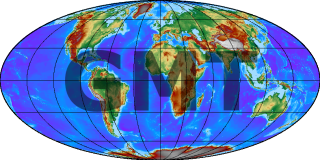
Generic Mapping Tools (GMT) are an open-source collection of computer software tools for processing and displaying xy and xyz datasets, including rasterisation, filtering and other image processing operations, and various kinds of map projections. The software stores 2-D grids as COARDS-compliant netCDF files and comes with a comprehensive collection of free GIS data, such as coast lines, rivers, political borders and coordinates of other geographic objects. Users convert further data from other sources and import them. GMT stores the resulting maps and diagrams in PostScript (PS) or Encapsulated PostScript (EPS) format.
Google Earth is a computer program, formerly known as Keyhole EarthViewer, that renders a 3D representation of Earth based primarily on satellite imagery. The program maps the Earth by superimposing satellite images, aerial photography, and GIS data onto a 3D globe, allowing users to see cities and landscapes from various angles. Users can explore the globe by entering addresses and coordinates, or by using a keyboard or mouse. The program can also be downloaded on a smartphone or tablet, using a touch screen or stylus to navigate. Users may use the program to add their own data using Keyhole Markup Language and upload them through various sources, such as forums or blogs. Google Earth is able to show various kinds of images overlaid on the surface of the earth and is also a Web Map Service client. Recently Google has revealed that Google Earth now covers more than 98 percent of the world, and has captured 10 million miles of Street View imagery, a distance that could circle the globe more than 400 times.

Bing Maps is a web mapping service provided as a part of Microsoft's Bing suite of search engines and powered by the Bing Maps for Enterprise framework.
The Vector Map (VMAP), also called Vector Smart Map, is a vector-based collection of geographic information system (GIS) data about Earth at various levels of detail. Level 0 coverage is global and entirely in the public domain. Level 1 is only partly in the public domain.
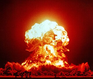
A nuclear explosion is an explosion that occurs as a result of the rapid release of energy from a high-speed nuclear reaction. The driving reaction may be nuclear fission or nuclear fusion or a multi-stage cascading combination of the two, though to date all fusion-based weapons have used a fission device to initiate fusion, and a pure fusion weapon remains a hypothetical device.
Wikimapia is a geographic online encyclopedia project. The project implements an interactive "clickable" web map that utilizes Google Maps with a geographically-referenced wiki system, with the aim to mark and describe all geographical objects in the world.
Google Developers is Google's site for software development tools and platforms, application programming interfaces (APIs), and technical resources. The site contains documentation on using Google developer tools and APIs—including discussion groups and blogs for developers using Google's developer products.
United Nations Security Council Resolution 1747 was a United Nations Security Council resolution, written with reference to some IAEA reports, that tightened the sanctions imposed on Iran in connection with the Iranian nuclear program. It was adopted unanimously by the United Nations Security Council on 24 March 2007.
Cartographic censorship is the deliberate modification of publicly available maps in order to disguise, remove, or obfuscate potentially strategic locations or buildings, such as military bases, power plants or transmitters. Sensitive objects and places have been removed from maps since historic times, sometimes as a disinformation tactic in times of war, and also to serve competitive political and economic interests, such as during the Age of Discovery when strategic geographic information was highly sought after. In modern times requests for censorship are sent to Google Earth for certain sites that are deemed to pose security risks for national governments.
Google Sites is a structured wiki- and web page-creation tool included as part of the free, web-based Google Docs Editors suite offered by Google. The service also includes Google Docs, Google Sheets, Google Slides, Google Drawings, Google Forms, and Google Keep. Google Sites is only available as a web application. The app allows users to create and edit files online while collaborating with other users in real-time.

The Preparatory Commission for the Comprehensive Nuclear-Test-Ban Treaty Organization, or CTBTO Preparatory Commission is an international organization based in Vienna, Austria, that is tasked with building up the verification regime of the Comprehensive Nuclear-Test-Ban Treaty Organization (CTBTO). The organization was established by the States Signatories to the Comprehensive Nuclear-Test-Ban Treaty (CTBT) in 1996.

MyTracks was a GPS tracking application that runs on Android. The application uses a device's GPS to collect data, allowing real-time review of path, speed, distance, and elevation. Later, this data can be saved to Google Maps, Google Fusion Tables, or Google Docs and shared with Google+, Facebook, or Twitter. The application also allows a user to record annotations along the path, hear periodic voice announcements of progress, and sync with select third-party bio-metric sensors.

Ryongsong Residence, also called Residence No. 55 and known by locals as Central Luxury Mansion is a presidential palace in North Korea and the main residence of North Korean Supreme Leader Kim Jong-un and First Lady of North Korea Ri Sol-ju.

Kangdong Residence is the summer retreat and second major residence of the North Korean leader Kim Jong-un besides Ryongsong Residence.

There are more than a dozen leader's residences in North Korea, according to Kim Jong-il’s former bodyguard Lee Young-kuk. Many of the residences were identified on satellite images in the North Korea Uncovered project. Ryongsong Residence is the central residence of Kim Jong-un. All residences are kept secret by the North Korean government and few photographs exist.
The following lists events that happened in 2013 in the Democratic People's Republic of Korea.
References
- ↑ Asher Moses (2009-06-02). "Amateur spies put North Korea on the map". Brisbane Times (BrisbaneTimes.com.au), Australia. Archived from the original on 2009-06-11. Retrieved 2009-06-02.
- ↑ "North Korean Economy Watch". Archived from the original on 2012-04-15. Retrieved 2012-04-14.