San Francisco, officially the City and County of San Francisco, is a commercial, financial, and cultural center within Northern California. With a population of 808,988 residents as of 2023, San Francisco is the fourth-most populous city in the U.S. state of California behind Los Angeles, San Diego, and San Jose. It covers a land area of 46.9 square miles at the upper end of the San Francisco Peninsula, making it the second-most densely populated major U.S. city behind New York City and the fifth-most densely populated U.S. county, behind four of New York City's boroughs. Among the 92 U.S. cities proper with over 250,000 residents, San Francisco is ranked first by per capita income and sixth by aggregate income as of 2022. San Francisco anchors the 13th most populous metropolitan statistical area in the United States, with almost 4.6 million residents in 2023. The larger San Jose–San Francisco–Oakland combined statistical area, the fifth-largest urban region in the U.S., had a 2023 estimated population of over 9 million.

Emeryville is a city located in northwest Alameda County, California, in the United States. It lies in a corridor between the cities of Berkeley and Oakland, with a border on the shore of San Francisco Bay. The resident population was 12,905 as of 2020. Its proximity to San Francisco, the Bay Bridge, the University of California, Berkeley, and Silicon Valley has been a catalyst for recent economic growth.

Yerba Buena Island sits in San Francisco Bay within the borders of the City and County of San Francisco. The Yerba Buena Tunnel runs through its center and connects the western and eastern spans of the San Francisco–Oakland Bay Bridge, linking the city with Oakland, California. Treasure Island is connected by a causeway to Yerba Buena Island. According to the United States Census Bureau, Yerba Buena Island and Treasure Island together have a land area of 0.901 square miles (2.33 km2) with a total population of 2,500 as of the 2010 census.

The San Francisco–Oakland Bay Bridge, commonly referred to as the Bay Bridge, is a complex of bridges spanning San Francisco Bay in California. As part of Interstate 80 and the direct road between San Francisco and Oakland, it carries about 260,000 vehicles a day on its two decks. It includes one of the longest bridge spans in the United States.

Treasure Island is an artificial island in San Francisco Bay, and a neighborhood in the City and County of San Francisco. Built in 1936–37 for the 1939 Golden Gate International Exposition, the island was named by Clyde Milner Vandeburg, part of the Fair's public relations team. Its World's Fair site is a California Historical Landmark. Buildings there have been listed on the National Register of Historic Places, and the historical Naval Station Treasure Island, an auxiliary air facility, are designated in the Geographic Names Information System. Treasure Island is connected to Yerba Buena Island, another (natural) auxiliary island of San Francisco, by a causeway, creating access to Interstate 80.

Yerba Buena Gardens is the name for two blocks of public parks located between Third and Fourth, Mission and Folsom Streets in the South of Market (SoMA) neighbourhood of San Francisco, California. The first block bordered by Mission and Howard Streets was opened on October 11, 1993. The second block, between Howard and Folsom Streets, was opened in 1998, with a dedication to Martin Luther King Jr. by Mayor Willie Brown. A pedestrian bridge over Howard Street connects the two blocks, sitting on top of part of the Moscone Center convention center. The Yerba Buena Gardens were planned and built as the final centerpiece of the Yerba Buena Redevelopment Area which includes the Yerba Buena Center for the Arts. Yerba Buena Gardens Conservancy operates the property on behalf of the City and County of San Francisco.

The Embarcadero is the eastern waterfront of Port of San Francisco and a major roadway in San Francisco, California. It was constructed on reclaimed land along a three mile long engineered seawall, from which piers extend into the bay. It derives its name from the Spanish verb embarcar, meaning "to embark"; embarcadero itself means "the place to embark." The Central Embarcadero Piers Historic District was added to the National Register of Historic Places on November 20, 2002.

William Anthony Richardson was an early California entrepreneur, influential in the development of Yerba Buena, the forerunner of the city of San Francisco.

The Port of San Francisco is a semi-independent organization that oversees the port facilities at San Francisco, California, United States. It is run by a five-member commission, appointed by the Mayor subject to confirmation by a majority of the Board of Supervisors. The Port is responsible for managing the larger waterfront area that extends from the anchorage of the Golden Gate Bridge, along the Marina district, all the way around the north and east shores of the city of San Francisco including Fisherman's Wharf and the Embarcadero, and southward to the city line just beyond Candlestick Point. In 1968, the State of California, via the California State Lands Commission for the State-operated San Francisco Port Authority, transferred its responsibilities for the Harbor of San Francisco waterfront to the City and County of San Francisco / San Francisco Harbor Commission through the Burton Act AB2649. All eligible State port authority employees had the option to become employees of the City and County of San Francisco to maintain consistent operation of the Port of San Francisco.

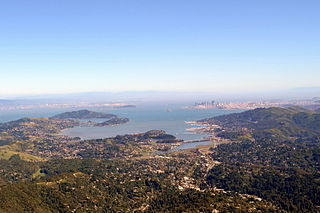
Richardson Bay is a shallow, ecologically rich arm of San Francisco Bay, managed under a Joint Powers Agency of four northern California cities. The 911-acre (369 ha) Richardson Bay Sanctuary was acquired in the early 1960s by the National Audubon Society. The bay was named for William A. Richardson, early 19th century sea captain and builder in San Francisco. It contains both Strawberry Spit and Aramburu Island.

The Berkeley Marina is the westernmost portion of the city of Berkeley, California, located west of the Eastshore Freeway at the foot of University Avenue on San Francisco Bay. Narrowly speaking, "Berkeley Marina" refers only to the city marina, but in common usage, it applies more generally to the surrounding area. The Berkeley Marina is a hub for various water activities, offering opportunities for kayaking, stand-up paddleboarding, windsurfing, open-water swimming, and kiteboarding. Outdoor enthusiasts gather to enjoy the scenic bay, catch the wind for a sail, or practice their water sports skills.

Dogpatch is a neighborhood in San Francisco, California, roughly half industrial and half residential. It was initially a working class neighborhood, but has experienced rapid gentrification since the 1990s. It now has similar demographics to its western neighbor Potrero Hill – an upper middle-class working professional neighborhood.

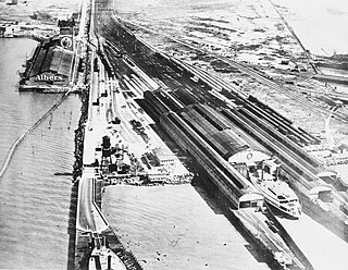
The Oakland Long Wharf was an 11,000-foot railroad wharf and ferry pier along the east shore of San Francisco Bay located at the foot of Seventh Street in West Oakland. The Oakland Long Wharf was built, beginning 1868, by the Central Pacific Railroad on what was previously Oakland Point. Beginning November 8, 1869, it served as the west coast terminus of the First transcontinental railroad. In the 1880s, Southern Pacific Railroad took over the CPRR, extending it and creating a new ferry terminal building with the official station name Oakland Pier. The entire structure became commonly and popularly called the Oakland Mole. Portions of the Wharf lasted until the 1960s. The site is now part of the facilities of the Port of Oakland, while passenger train service operates at the nearby Jack London Square/Dellums Station and another nearby station in Emeryville.

The Point Montara Light is a lighthouse in Montara, California, United States, on the southern approach to the San Francisco Bay, California approximately 25 miles south of San Francisco.

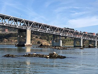
The Castro Rocks are several rocks in Richmond, California, protruding from the waters in San Francisco Bay between Castro Point and Red Rock Island. The rocks lie almost directly under the Richmond-San Rafael Bridge (I-580).

Yerba Buena was the name of an anchorage spot and later a town that grew into the city of San Francisco, California. The settlement was founded in 1834 and was located near the northeastern end of the San Francisco Peninsula, on the shores of Yerba Buena Cove. Yerba Buena was the first civilian pueblo in San Francisco, which had previously only had indigenous, missionary, and military settlements, and was originally intended as a trading post for ships visiting San Francisco Bay. The settlement was arranged in the Spanish style around a plaza that remains as the present day Portsmouth Square. The area that was the Yerba Buena settlement is now in the Financial District and Chinatown neighborhoods of San Francisco.
Rancho Potrero de San Francisco or Rancho Potrero Nuevo was approximately 1,000-acre (4.0 km2) Mexican land grant in the present day Potrero Hill neighborhood of San Francisco, California.

Yerba Buena Cove was a cove on San Francisco Bay where the Mexican town of Yerba Buena was located. It lay between Clarks Point to the north and Rincon Point to the south. The beach of the cove was set as far back as what is now Montgomery Street between Clay and Washington Streets.

Rincon Point, was a cape marking the southern extremity of Yerba Buena Cove in what is now San Francisco, California. Rincón is Spanish for "corner", and the point formed the southern corner of the cove.

Clarks Point was a cape on the north side of Yerba Buena Cove in what is now San Francisco, California.


