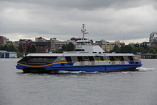
The SeaBus is a passenger-only ferry service in Metro Vancouver, British Columbia, Canada. It crosses Burrard Inlet to connect the cities of Vancouver and North Vancouver. Owned by TransLink and operated by the Coast Mountain Bus Company, the SeaBus forms an important part of the region's integrated public transportation system. In 2023, the SeaBus had a ridership of 5,127,000, or about 17,300 per weekday as of the third quarter of 2024.

The Ironworkers Memorial Second Narrows Crossing, also called the Ironworkers Memorial Bridge and Second Narrows Bridge, is the second bridge constructed at the Second (east) Narrows of Burrard Inlet in Vancouver, British Columbia, Canada. Originally named the Second Narrows Bridge, it connects Vancouver to the North Shore of Burrard Inlet, which includes the District of North Vancouver, the City of North Vancouver, and West Vancouver. It was constructed adjacent to the older Second Narrows Bridge, which is now exclusively a rail bridge. Its construction, from 1956 to 1960, was marred by a multi-death collapse on June 17, 1958. The First Narrows Bridge, better known as Lions Gate Bridge, crosses Burrard Inlet about 8 kilometres (5.0 mi) west of the Second Narrows.

The Second Narrows Rail Bridge is a vertical-lift railway bridge that crosses the Burrard Inlet and connects Vancouver with the North Shore. The bridge's south end connects directly to the Thornton Tunnel, which connects it to the main Canadian rail network. As the name suggests, it is located at the second narrowing of the Burrard Inlet.

The City of North Vancouver is a city municipality on the North Shore of the Burrard Inlet, in British Columbia, Canada. Anchored by the downtown town centre of Lonsdale, with which its urban core is largely synonymous, it consists of the smallest and most urbanized of the communities situated north of the city of Vancouver, and is part of the Metro Vancouver regional district, though it has significant industry of its own – including shipping, chemical production, and film production. The city is served by the Royal Canadian Mounted Police, British Columbia Ambulance Service, and the North Vancouver City Fire Department.

The Island Corridor, previously the Esquimalt & Nanaimo Railway, is a railway operation on Vancouver Island. It is owned by the Island Corridor Foundation, a registered charity. The railway line is 225 kilometres (140 mi) in length from Victoria to Courtenay, known as the Victoria Subdivision, with a branch line from Parksville to Port Alberni, known as the Port Alberni Subdivision, of 64 kilometres (40 mi), for a total 289 kilometres (180 mi) of mainline track. In 2006, the Island Corridor Foundation acquired the railway's ownership from RailAmerica and Canadian Pacific Railway.

Burrard Inlet is a shallow-sided fjord in the northwestern Lower Mainland, British Columbia, Canada. Formed during the last Ice Age, it separates the City of Vancouver and the rest of the lowland Burrard Peninsula to the south from the coastal slopes of the North Shore Mountains, which span West Vancouver and the City and District of North Vancouver to the north.

The Burrard Peninsula is a peninsula in the Lower Mainland region of British Columbia, Canada, bounded by the Burrard Inlet to the north, the Georgia Strait to the west, the North Arm of Fraser River to the south, and the Pitt River and Douglas Island to the east. The City of Vancouver occupies almost all of the western half of the peninsula, and the Cities of Burnaby and New Westminster occupy more than half of the eastern half. At its northeastern end, the peninsula is connected to the Eagle Mountain and Mount Burke of the Coast Mountains via a small isthmus at the center of the Tri-Cities.

The District of North Vancouver is a district municipality in British Columbia, Canada, situated north of the city of Vancouver across the Burrard Inlet. It surrounds the respective City of North Vancouver on three sides, and the remaining fellow North Shore municipality of West Vancouver on the other, and is part of the Metro Vancouver Regional District.
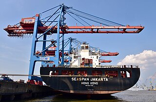
Seaspan ULC provides marine-related services to the Pacific Northwest. Within the Group are three (3) shipyards, an intermodal ferry and car float business, along with a tug and barge transportation company that serves both domestic and international markets. Seaspan, is part of the Washington Companies that are owned by Dennis Washington. Kyle Washington, is the Executive Chairman of Seaspan, who has become a Canadian citizen.

The British Columbia Coast, popularly referred to as the BC Coast or simply the Coast, is a geographic region of the Canadian province of British Columbia. As the entire western continental coastline of Canada along the Pacific Ocean is in the province, it is synonymous with being the West Coast of Canada.

Bute Inlet is one of the principal inlets of the British Columbia Coast. It is 80 km (50 mi) long from the estuaries of the Homathko and Southgate Rivers at the head of the inlet, to the mouth, where it is nearly blocked by Stuart Island, and it averages about 4 km (2.5 mi) in width. Bute Inlet is in a spectacular wilderness setting and is one of the most scenic waterways in the world. In the upper reaches of the inlet mountains rise 2,700 m (9,000 ft) feet above sea level. Bute Inlet is a spectacular wilderness that is visited by very few people. In more recent years tourists are travelling from around the world to view grizzly bears in a natural setting and explore the wilderness of Bute Inlet.

Jervis Inlet is one of the principal inlets of the British Columbia Coast, about 95 km (59 mi) northwest of Vancouver, and the third of such inlets north of the 49th parallel, the first of which is Burrard Inlet, Vancouver's harbour.

Downtown Vancouver is the central business district and the city centre neighbourhood of Vancouver, Canada, on the northwestern shore of the Burrard Peninsula in the Lower Mainland region of British Columbia. It occupies most of the north shore of the False Creek inlet, which cuts into the Burrard Peninsula creating the Downtown Peninsula, where the West End neighbourhood and Stanley Park are also located.
Transportation in Vancouver, British Columbia, has many of the features of modern cities worldwide. Unlike many large metropolises, Vancouver has no freeways into or through the downtown area. A proposed freeway through the downtown was rejected in the 1960s by a coalition of citizens, community leaders and planners. This event "signalled the emergence of a new concept of the urban landscape" and has been a consistent element of the city's planning ever since.

The history of Vancouver, British Columbia, is one that extends back thousands of years, with its first inhabitants arriving in the area following the Last Glacial Period. With its location on the western coast of Canada near the mouth of the Fraser River and on the waterways of the Strait of Georgia, Howe Sound, Burrard Inlet, and their tributaries, Vancouver has – for thousands of years – been a place of meeting, trade, and settlement.

Capitol Hill, elev. 203m, is a hill in the city of Burnaby, British Columbia, Canada, and also is the name of the neighbourhood spanning the summit of the hill. Standing on the north side of Hastings Street and bounded by Willingdon Avenue to the west and Fell Avenue in the east, this neighbourhood is known for its Italian, Portuguese, and Croatian expat communities, as well as being a student area associated with the nearby Simon Fraser University.
The Thornton Tunnel is a freight railway tunnel in Burnaby, British Columbia, running under the Willingdon Heights and Vancouver Heights neighbourhoods. The tunnel is named after Sir Henry Worth Thornton, who was an early president of Canadian National Railway (CN). CN built the tunnel in 1969 to connect the rail-only version of the Second Narrows Bridge, which was built one year earlier, to the main line in Willingdon. The tunnel is 3.4 kilometres (2.1 mi) long, and it is a single-track railway.

Prospect Point is a point at the northern tip of Stanley Park in Vancouver, British Columbia, Canada, located on the south side of the First Narrows of Burrard Inlet. The point, which as its name suggests, is a viewpoint, landmark and tourist attraction in Stanley Park and has a restaurant and other facilities, is just west of the Lions Gate Bridge.
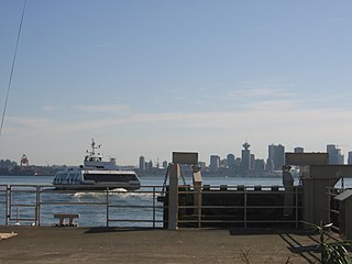
Lonsdale Quay is a SeaBus ferry terminal and major transit exchange in the City of North Vancouver, and serves Metro Vancouver's North Shore municipalities. Located at the waterfront of the Lower Lonsdale neighbourhood, the transit hub is within short distance from the BCIT Marine Campus and Lonsdale Quay Market.

First Narrows is the official name for the entrance to Burrard Inlet, the mouth of Vancouver, British Columbia's inner harbour.
