Related Research Articles

The Gulf of St. Lawrence is the outlet of the North American Great Lakes via the St. Lawrence River into the Atlantic Ocean. The gulf is a semi-enclosed sea, covering an area of about 226,000 square kilometres (87,000 sq mi) and containing about 34,500 cubic kilometres (8,300 cu mi) of water, which results in an average depth of 152 metres (499 ft).
Chaleur Bay, also Chaleurs bay, baie of Chaleur is an arm of the Gulf of Saint Lawrence located between Quebec and New Brunswick, Canada.

Miramichi is the largest city in northern New Brunswick, Canada. It is situated at the mouth of the Miramichi River where it enters Miramichi Bay. The Miramichi Valley is the second longest valley in New Brunswick, after the Saint John River Valley.

Northumberland County is located in northeastern New Brunswick, Canada.

The Miramichi River is a river located in the east-central part of New Brunswick, Canada. The river drains into Miramichi Bay in the Gulf of St. Lawrence. The name may have been derived from the Montagnais words "Maissimeu Assi", and it is today the namesake of the Miramichi Herald at the Canadian Heraldic Authority.

Chatham is an urban neighbourhood in the city of Miramichi, New Brunswick, Canada.

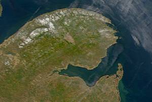
Miramichi Bay is an estuary located on the west coast of the Gulf of St. Lawrence in New Brunswick, at the mouth of the Miramichi River. Miramichi Bay is separated into the "inner bay" and the "outer bay", with the division being a line of uninhabited barrier islands which are continually reshaped by ocean storms. The largest of these islands is the uninhabited Portage Island, which was broken in two during a violent storm in the 1950s. The islands provide some protection to the inner bay from ocean storms in the Gulf of St. Lawrence.
The Miramichi Valley is a Canadian river valley and region in the east-central part of New Brunswick. It extends along both major branches of the Miramichi River and their tributaries, however it is generally agreed that the much larger Southwest Miramichi River forms the majority of this region as it is more settled than the Northwest Miramichi River.

Alnwick is a civil parish in Northumberland County, New Brunswick, Canada.

The Acadian Peninsula is situated in the northeastern corner of New Brunswick, Canada, encompassing portions of Gloucester and Northumberland Counties. It derives its name from the large Acadian population located there. Two major islands off the northeast tip of the peninsula, Lamèque Island and Miscou Island, are culturally considered part of the Acadian Peninsula.
Neguac is a Canadian village in Northumberland County, New Brunswick.

Baie-Sainte-Anne is a rural community in Northumberland County, New Brunswick, Canada.

The history of New Brunswick covers the period from the arrival of the Paleo-Indians thousands of years ago to the present day. Prior to European colonization, the lands encompassing present-day New Brunswick were inhabited for millennia by the several First Nations groups, most notably the Maliseet, Mi'kmaq, and the Passamaquoddy.

New Brunswick is one of Canada's three Maritime provinces. While New Brunswick is one of Canada's Maritime Provinces, it differs from its neighbours both ethnoculturally and physiographically. Both Nova Scotia and Prince Edward Island are either wholly or nearly surrounded by water and the ocean, therefore, tends to define their climate, economy and culture. New Brunswick, on the other hand, although having a significant seacoast, is sheltered from the Atlantic Ocean proper and has a large interior that is removed from oceanic effects. New Brunswick, therefore, tends to be defined by its rivers rather than its seacoast.

Lamèque Island, , is a Canadian island in the Gulf of St. Lawrence at the northeastern tip of Gloucester County, New Brunswick.

The Nova Scotia peninsula is a peninsula on the Atlantic coast of North America.
Bay du Vin is a small but picturesque unincorporated community located on the south shore of Miramichi Bay, 24 km east of the former town of Chatham, New Brunswick, Canada. It is suggested that its name comes from a corruption of the French "Baie de Vents" meaning "Bay of Winds" rather than the widely supposed "Bay of Wine" in the literal translation.

Hardwicke is a civil parish in Northumberland County, New Brunswick, Canada.

Shippegan is a civil parish in Gloucester County, New Brunswick, Canada. Located in the northeastern corner of the province at the end of the Acadian Peninsula, the parish consists of the three main islands of Taylor, Lamèque, and Miscou, along with several smaller islands and tidal wetlands; Taylor Island is now joined to the mainland by an isthmus, which is crossed by a causeway.
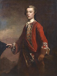
The Gulf of St. Lawrence campaign occurred during the French and Indian War when British forces raided villages along present-day New Brunswick and the Gaspé Peninsula coast of the Gulf of Saint Lawrence. Sir Charles Hardy and Brigadier-General James Wolfe were in command of the naval and military forces respectively. After the siege of Louisbourg, Wolfe and Hardy led a force of 1,500 troops in nine vessels to the Gaspé Bay arriving there on September 5. From there they dispatched troops to Miramichi Bay, Grande-Rivière, Quebec and Pabos, and Mont-Louis, Quebec. Over the following weeks, Sir Charles Hardy took 4 sloops or schooners, destroyed about 200 fishing vessels and took about two hundred prisoners.
References
Citations of Use of the Term
- Faragher, John Mack (2005). A Great and Noble Scheme: The Tragic Story of the Expulsion of the French Acadians from Their American Homeland . W.W Norton & Company. pp. 437, 453. ISBN 978-0-393-05135-3.
- p 59, The Maritime Provinces: A Handbook for Travellers, A Guide to the Chief Cities..., 3rd Ed. James R. Osgood & Co. Boston, USA, 1883.