
Avon Water, also known locally as the River Avon, is a 24-mile-long (39 km) river in Scotland, and a tributary of the River Clyde.

The River Forth is a major river in central Scotland, 47 km (29 mi) long, which drains into the North Sea on the east coast of the country. Its drainage basin covers much of Stirlingshire in Scotland's Central Belt. The Gaelic name for the upper reach of the river, above Stirling, is Abhainn Dubh, meaning "black river". The name for the river below the tidal reach is Uisge For.

Kinghorn is a town and parish in Fife, Scotland. A seaside resort with two beaches, Kinghorn Beach and Pettycur Bay, plus a fishing port, it stands on the north shore of the Firth of Forth, opposite Edinburgh.

Kyle of Lochalsh is a village in the historic county of Ross & Cromarty on the northwest coast of Scotland, located around 55 miles (90 km) west-southwest of Inverness. It is located on the Lochalsh peninsula, at the entrance to Loch Alsh, opposite the village of Kyleakin on the Isle of Skye. A ferry used to connect the two villages until it was replaced by the Skye Bridge, about a mile (2 km) to the west, in 1995.
The River Irk is a river in the historic county of Lancashire in the North West England that flows through the northern most Lancastrian towns of the ceremonial county of Greater Manchester.

The West Highland Line is a railway line linking the ports of Mallaig and Oban in the Scottish Highlands to Glasgow in Central Scotland. The line was voted the top rail journey in the world by readers of independent travel magazine Wanderlust in 2009, ahead of the notable Trans-Siberian line in Russia and the Cuzco to Machu Picchu line in Peru. The ScotRail website has since reported that the line has been voted the most scenic railway line in the world for the second year running.

The River Wansbeck runs through the county of Northumberland, England. It rises above Sweethope Lough on the edge of Fourlaws Forest in the area known locally as The Wanneys ; runs through the town of Ashington before discharging into the North Sea at Sandy Bay near Newbiggin-by-the-Sea.

Montrose railway station serves the town of Montrose in Angus, Scotland. The station overlooks the Montrose Basin and is situated on the Dundee–Aberdeen line, 90 miles (144 km) north of Edinburgh Waverley, between Arbroath and Laurencekirk. There is a crossover at the north end of the station, which can be used to facilitate trains turning back if the line south to Arbroath is blocked.

St Cyrus or Saint Cyrus, formerly Ecclesgreig is a village in the far south of Aberdeenshire, Scotland.

Laigh Milton Viaduct is a railway viaduct near Laigh Milton mill to the west of Gatehead in East Ayrshire, Scotland, about five miles west of Kilmarnock. It is probably the world's earliest surviving railway viaduct on a public railway, and the earliest known survivor of a type of multi-span railway structure subsequently adopted universally.

Marykirk is a village in the Kincardine and Mearns area of Aberdeenshire, Scotland, next to the border with Angus at the River North Esk.

The Leaderfoot Viaduct, also known as the Drygrange Viaduct, is a railway viaduct over the River Tweed near Melrose in the Scottish Borders.

The Caledonian Railway Bridge is a bridge crossing the River Clyde at Broomielaw in Scotland. It is adjacent to Glasgow Central Station.
The North British, Arbroath and Montrose Railway was a company established by Act of Parliament in 1871 to construct and operate a railway line from north of Arbroath via Montrose to Kinnaber Junction, 38 miles (61 km) south of Aberdeen. The company was originally a subsidiary of the North British Railway but was absorbed into its parent in 1880.
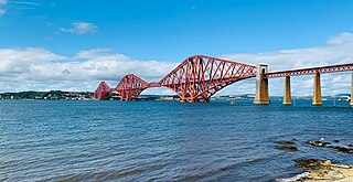
The Forth Bridge is a cantilever railway bridge across the Firth of Forth in the east of Scotland, 9 miles west of central Edinburgh. Completed in 1890, it is considered a symbol of Scotland, and is a UNESCO World Heritage Site. It was designed by English engineers Sir John Fowler and Sir Benjamin Baker. It is sometimes referred to as the Forth Rail Bridge, although this is not its official name.
Mennock is a small village or hamlet which lies 2 miles (3.2 km) south-east of Sanquhar on the A76, in Dumfriesshire, in the District Council Region of Dumfries and Galloway, southwest Scotland. Its original nucleus are the old smithy and corn mill with associated buildings. The site is dominated by the A76 that runs through the centre of Mennock. The village has expanded in recent years with housing on the River Nith side of the A76.
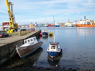
Ferryden is a village in Angus, Scotland in the community council area of Ferryden & Craig. It lies southerly adjacent to the town of Montrose on the south bank of the South Esk and is considered a fringe locality of Montrose, being connected to the latter by the former Rossie Island, now home to shipping facilities and Montrose Port Authority.

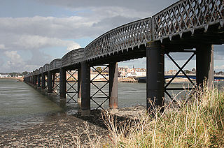
The Lower North Water Bridge is a road bridge north of Montrose, Scotland. It carries the A92 over the River North Esk. It is situated on the border between Angus and Aberdeenshire. It is adjacent to the North Water Viaduct which previously carried the Montrose and Bervie Railway and is now a footpath.

Croft Viaduct is a railway bridge carrying the East Coast Main Line between Northallerton and Darlington in Northern England. The viaduct crosses the River Tees, the border between North Yorkshire and County Durham. Although it was an early example of a stone viaduct in the railway system, it is not the first true railway viaduct, however, it was the first railway viaduct in the United Kingdom to have been built with an oblique arch. It was grade II listed in 1988, and had overhead line equipment installed in the early 1990s.

