The Northampton Medieval Synagogue is an archaeological site and medieval synagogue building in Sheep Street, Northampton, England.
The synagogue was discovered in 2010 by Marcus Roberts of National Anglo-Jewish Heritage Trail (JTrails) after many years of researching Northampton's medieval Jewish history. Records tell that the synagogue appeared to have survived the expulsion of Jews in 1290 and the great fire of Northampton in 1674. Town clerk records from 1751 describe the building as "very substantial; a fair stately hall." [1]
The remains of the medieval synagogue include stone walls and a stone staircase located 12 feet underneath a kebab shop, the Kebabish takeaway, and a neighbourhood pub. A wall in the cellar of the pub, named "The Bear," was part of the ancient synagogue. [1]
Northampton was among the largest medieval Jewish communities in England. Remnants of a Jewish cemetery have also been discovered by archaeologists.

A synagogue, also called a shul or a temple, is a place of worship for Jews and Samaritans. It has a place for prayer where Jews attend religious services or special ceremonies such as weddings, bar and bat mitzvahs, choir performances, and children's plays. They also have rooms for study, social halls, administrative and charitable offices, classrooms for religious and Hebrew studies, and many places to sit and congregate. They often display commemorative, historic, or modern artwork alongside items of Jewish historical significance or history about the synagogue itself.
Manchester Jewish Museum occupies the former Spanish and Portuguese synagogue and an adjacent building on Cheetham Hill Road in Manchester, England. It is a grade II* listed building.

Bevis Marks Synagogue, officially Qahal Kadosh Sha'ar ha-Shamayim, is an Orthodox Jewish congregation and synagogue, located off Bevis Marks, Aldgate, in the City of London, England, in the United Kingdom. The congregation is affiliated to London's historic Spanish and Portuguese Jewish community and worships in the Sephardic rite.

Jews' Court is a Grade I listed building on Steep Hill in Lincoln, England. It houses the headquarters of the Society for Lincolnshire History and Archaeology.

Heaton Park Hebrew Congregation is a large Ashkenazi Orthodox synagogue located in North Manchester, United Kingdom. It was founded in 1935, and in 2010 had between 500 and 749 members. Under the aegis of the Chief Rabbi of the United Kingdom, Reverend Leslie Olsberg MBE led the congregation for 35 years until his death in 2008. Rabbi Daniel Walker succeeded him, and currently heads the congregation. Yehuda Marx is the hazzan.
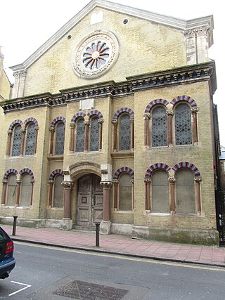
The Old Synagogue in Canterbury is considered to be the best example of an Egyptian Revival synagogue.

Guildford Synagogue refers both to a probably medieval synagogue and to a modern congregation in Guildford, Surrey, England.

Historic synagogues include synagogues that date back to ancient times and synagogues that represent the earliest Jewish presence in cities around the world. Some synagogues were destroyed and rebuilt several times on the same site. Others were converted into churches and mosques or used for other purposes.
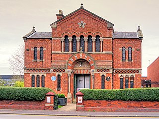
The Middle Street Synagogue is a synagogue in the centre of Brighton, part of the English city of Brighton and Hove. It was the centre for Jewish worship in Brighton and Hove for more than a century. Although it is not in full-time use, the building is still open at certain times, and cultural events frequently take place, as do weddings. It has been listed at Grade II*, reflecting its architectural and historic importance.

The Cheltenham Synagogue is a synagogue in Cheltenham and is noted for its Regency architecture. It is an independent congregation located in the town centre on Synagogue Lane, off St James's Square.

Sandy's Row Synagogue is an Orthodox Jewish congregation and synagogue, located on Sandys Row, on the corner of Middlesex Street in Bishopsgate, in the East End, Borough of Tower Hamlets, London, England, in the United Kingdom.
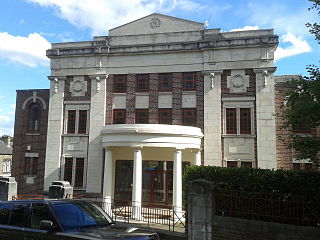
Birmingham Central Synagogue is an Orthodox synagogue situated in Edgbaston, Birmingham, England.

Exeter Synagogue is in Synagogue Place, Mary Arches Street within the old city of Exeter, Devon, and is the third oldest synagogue in the United Kingdom. Originally built as a Sephardi synagogue for Dutch Jews trading in Exeter, it is now a synagogue of the Ashkenazi rite. Exeter Hebrew Congregation itself existed shortly prior to its construction.

Beth Shalom Reform Synagogue is a synagogue in the City of Cambridge. Founded in 1981, it held services in hired premises until 2015 when the community opened a new synagogue on a site on Auckland Road, the first Reform synagogue in Cambridge. The new building includes a prayer hall for at least 200 people. The building was dedicated on 6 September 2015 at a service led by Fiona Karet Frankl and addressed by Rabbi Laura Janner-Klausner, senior rabbi to the Movement for Reform Judaism.

Bradford Synagogue is a synagogue at 7 Bowland Street in Bradford, West Yorkshire, affiliated with the Movement for Reform Judaism. It adopted its present name in 2018. The synagogue is still used for Shabbat and major festivals although the community is small and has been in decline for some years. Friday night dinners are held as well as a communal seder for Passover.

Brighton and Hove Reform Synagogue is a synagogue in Hove, Sussex, England. It has 500 adult members.
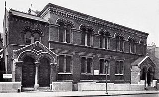
Bayswater Synagogue was an Orthodox Jewish congregation and synagogue located in Chichester Place, Paddington, in the City of Westminster, London, England, in the United Kingdom. The congregation worshiped in the Ashkenazi rite.

Manchester Reform Synagogue, a member of the Movement for Reform Judaism, is one of the oldest Reform Jewish communities in the United Kingdom. Founded in 1857 with congregation president Horatio Michollis and Rabbi Solomon Marcus Schiller-Szinessy under the name Manchester Congregation of British Jews by a group consisting mainly of German-Jewish immigrants, the synagogue is located in central Manchester at Jackson's Row. The congregation bought that site in 1949.
The Wilson Road Synagogue is a former Orthodox Jewish congregation and synagogue, located at 11 Wilson Road, Ecclesall, Sheffield, England, in the United Kingdom. The congregation was formed in 1914 and worshiped in the Ashkenazi rite until the congregation was dissolved in 1997.