
The Arctic is a polar region located at the northernmost part of Earth. The Arctic region, from the IERS Reference Meridian travelling east, consists of parts of northern Norway, northernmost Sweden, northern Finland, Russia, the United States (Alaska), Canada, Danish Realm (Greenland), and northern Iceland, along with the Arctic Ocean and adjacent seas. Land within the Arctic region has seasonally varying snow and ice cover, with predominantly treeless permafrost under the tundra. Arctic seas contain seasonal sea ice in many places.
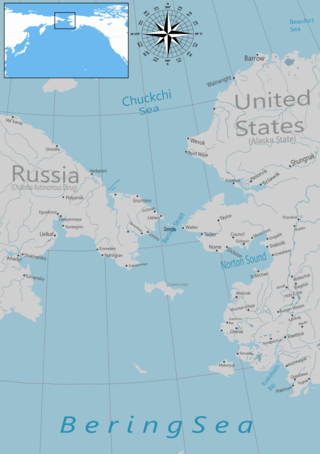
The Bering Strait is a strait between the Pacific and Arctic oceans, separating the Chukchi Peninsula of the Russian Far East from the Seward Peninsula of Alaska. The present Russia-United States maritime boundary is at 168° 58' 37" W longitude, slightly south of the Arctic Circle at about 65° 40' N latitude. The Strait is named after Vitus Bering, a Danish explorer in the service of the Russian Empire.

The Bering Sea is a marginal sea of the Northern Pacific Ocean. It forms, along with the Bering Strait, the divide between the two largest landmasses on Earth: Eurasia and the Americas. It comprises a deep water basin, which then rises through a narrow slope into the shallower water above the continental shelves. The Bering Sea is named after Vitus Bering, a Danish navigator in Russian service, who, in 1728, was the first European to systematically explore it, sailing from the Pacific Ocean northward to the Arctic Ocean.

The Arctic National Wildlife Refuge or Arctic Refuge is a national wildlife refuge in northeastern Alaska, United States, on traditional Iñupiaq and Gwich'in lands. The refuge is 19,286,722 acres (78,050.59 km2) of the Alaska North Slope region, with a northern coastline and vast inland forest, taiga, and tundra regions. ANWR is the largest national wildlife refuge in the country, slightly larger than the Yukon Delta National Wildlife Refuge. The refuge is administered from offices in Fairbanks. ANWR is home to a diverse range of endemic mammal species; notably, it is one of the few North American locations with all three endemic American ursids—the polar bear, grizzly bear, and American black bear, each of which resides predominantly in its own ecological niche. Besides the bears, other mammal species include the moose, caribou, wolves, red and Arctic fox, Canada lynx, wolverine, pine marten, American beaver, and North American river otter. Further inland, mountain goats may be seen near the slope. Hundreds of species of migratory birds visit the refuge yearly, and it is a vital, protected breeding location for them. Snow geese, eiders and snowy owls may be observed as well.

Shishmaref is a city in the Nome Census Area, Alaska, United States. It is located on Sarichef Island in the Chukchi Sea, just north of the Bering Strait and five miles from the mainland. Shishmaref lies within the Bering Land Bridge National Preserve. The population was 563 at the 2010 census, up from 562 in 2000.

The Iñupiat are a group of Alaska Natives whose traditional territory roughly spans northeast from Norton Sound on the Bering Sea to the northernmost part of the Canada–United States border. Their current communities include 34 villages across Iñupiat Nunaat, including seven Alaskan villages in the North Slope Borough, affiliated with the Arctic Slope Regional Corporation; eleven villages in Northwest Arctic Borough; and sixteen villages affiliated with the Bering Straits Regional Corporation. They often claim to be the first people of the Kauwerak.

St. Lawrence Island is located west of mainland Alaska in the Bering Sea, just south of the Bering Strait. The village of Gambell, located on the northwest cape of the island, is 50 nautical miles from the Chukchi Peninsula in the Russian Far East. The island is part of Alaska, but closer to Russia and Asia than to the Alaskan and North American mainland. St. Lawrence Island is thought to be one of the last exposed portions of the land bridge that once joined Asia with North America during the Pleistocene period. It is the sixth largest island in the United States and the 113th largest island in the world. It is considered part of the Bering Sea Volcanic Province. The Saint Lawrence Island shrew is a species of shrew endemic to St. Lawrence Island. The island is jointly owned by the predominantly Siberian Yupik villages of Gambell and Savoonga, the two main settlements on the island.

The Chukchi Sea, sometimes referred to as the Chuuk Sea, Chukotsk Sea or the Sea of Chukotsk, is a marginal sea of the Arctic Ocean. It is bounded on the west by the Long Strait, off Wrangel Island, and in the east by Point Barrow, Alaska, beyond which lies the Beaufort Sea. The Bering Strait forms its southernmost limit and connects it to the Bering Sea and the Pacific Ocean. The principal port on the Chukchi Sea is Uelen in Russia. The International Date Line crosses the Chukchi Sea from northwest to southeast. It is displaced eastwards to avoid Wrangel Island as well as the Chukotka Autonomous Okrug on the Russian mainland.

The Pacific Marine Ecozone, as defined by the Commission for Environmental Cooperation (CEC), is a Canadian and American marine ecozone extending to the international waters of the Pacific Ocean from the coasts of Alaska, British Columbia, Washington and Oregon. The islands within the Canadian portion are part of the adjacent Pacific Maritime ecozone.

The bowhead whale is a species of baleen whale belonging to the family Balaenidae and is the only living representative of the genus Balaena. It is the only baleen whale endemic to the Arctic and subarctic waters, and is named after its characteristic massive triangular skull, which it uses to break through Arctic ice. Other common names of the species included the Greenland right whale, Arctic whale, steeple-top, and polar whale.

The North American Arctic is composed of the northern polar regions of Alaska (USA), Northern Canada and Greenland. Major bodies of water include the Arctic Ocean, Hudson Bay, the Gulf of Alaska and North Atlantic Ocean. The North American Arctic lies above the Arctic Circle. It is part of the Arctic, which is the northernmost region on Earth. The western limit is the Seward Peninsula and the Bering Strait. The southern limit is the Arctic Circle latitude of 66° 33’N, which is the approximate limit of the midnight sun and the polar night.

Arctic cooperation and politics are partially coordinated via the Arctic Council, composed of the eight Arctic nations: the United States, Canada, Iceland, Norway, Sweden, Finland, Russia, and Denmark with Greenland and the Faroe Islands. The dominant governmental power in Arctic policy resides within the executive offices, legislative bodies, and implementing agencies of the eight Arctic nations, and to a lesser extent other nations, such as United Kingdom, Germany, European Union and China. NGOs and academia play a large part in Arctic policy. Also important are intergovernmental bodies such as the United Nations and NATO.

The Arctic policy of the United States is the foreign policy of the United States in regard to the Arctic region. In addition, the United States' domestic policy toward Alaska is part of its Arctic policy.

Barrow Canyon is a submarine canyon that straddles the boundary between the Beaufort and Chukchi seas. Compared to other nearby areas and the Canada Basin, the highly productive Barrow Canyon supports a diversity of marine animals and invertebrates.
Herald Shoal is a region of high benthic productivity on the Chukchi Sea shelf. It serves as rich foraging habitat for many species of marine mammals and birds.

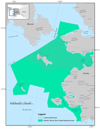
The Bering Strait has become vulnerable to climatic changes, trans Arctic shipping, and resource exploitation. The Obama administration's Executive Order 13754 of December 9, 2016 defines a Northern Bering Sea Climate Resilience Area that gives protection to the indigenous coastal communities that rely on the strait for subsistence hunting, and the surrounding marine ecosystem's vitality. It exists within the U.S exclusive economic zone and within maritime boundaries agreed upon between the Soviet Union and the U.S. The ecosystem, civilization, and international trade all rely on each other, thus encouraging the establishment of the sensitive marine areas in the Bering Strait. The executive order was upheld by international climate goals, and environmental management standards. Since the location is of international interest, it became vital to protect this area from further exploitation in the oil and shipping industry.
Early on in his campaign for election, former president Barack Obama made it clear that climate change was a priority for his administration. Soon after becoming President Elect in November 2008, he reiterated this positing stating: “Now is the time to confront this challenge once and for all. Delay is no longer an option. Denial is no longer an acceptable response.” Contradictory to his 2008 campaign promises on the Offshore drilling debate, Obama felt obliged to open coastal areas off the Alaskan coast to exploratory assessments for oil and gas as a means to continue to stimulate economic growth. This decision in March 2010 was abruptly reversed in May 2010 after the catastrophic failure of the Deep Water Horizon drilling operation, which led to the six-month moratorium on deep water drilling in the United States territorial waters.

The Marine Policy of the Barack Obama administration comprises several significant environmental policy decisions for the oceans made during his two terms in office from 2009 to 2017. By executive action, US President Barack Obama increased fourfold the amount of protected marine space in waters under United States control, setting a major precedent for global ocean conservation. Using the U.S. president's authority under the Antiquities Act of 1906, he expanded to 200 nautical miles the seaward limits of Papahānaumokuākea Marine National Monument in Hawaiʻi and the Pacific Remote Islands Marine National Monument around the U.S. island possessions in the Central Pacific. In the Atlantic, Obama created the Northeast Canyons and Seamounts Marine National Monument, the first marine monument in the U.S. exclusive economic zone (EEZ) in the Atlantic.
Phyllis Jean Stabeno is a physical oceanographer known for her research on the movement of water in polar regions. She has led award-winning research projects in the Arctic and was noted for a distinguished scientific career by the National Oceanic and Atmospheric Administration.

Sue E. Moore is a scientist at the University of Washington known for her research on marine mammals in the Arctic.
