Related Research Articles

Bexhill is a small village in New South Wales, Australia. As of 2006, the town had a population of 472 people. It is located about 35 kilometres (22 mi) from Byron Bay and about 11 kilometres (7 mi) from Lismore and is in the City of Lismore. It is on the Murwillumbah railway line and on Bangalow Road.

Lismore is a city located in the Northern Rivers region of New South Wales, Australia and the main population centre in the City of Lismore local government area, it is also a regional centre in the Northern Rivers region of the state. Lismore is 734 km (456 mi) north of Sydney and 200 km (120 mi) south of Brisbane. It is situated on a low floodplain on the banks of the Wilsons River near the latter's junction with Leycester Creek, both tributaries of the Richmond River which enters the Pacific Ocean at Ballina, 30 km (19 mi) to the east.

Byron Bay is a beachside town located in the far-northeastern corner of New South Wales, Australia. It is located 772 kilometres (480 mi) north of Sydney and 165 kilometres (103 mi) south of Brisbane. Cape Byron, a headland adjacent to the town, is the easternmost point of mainland Australia. At the 2021 census, the town had a permanent population of 6,330. It is the largest town of Byron Shire local government area, though not the shire's administrative centre.

Northern Rivers is the most northeasterly region of the Australian state of New South Wales, located between 590 and 820 kilometres north of the state capital, Sydney, and encompasses the catchments and fertile valleys of the Clarence, Richmond, and Tweed rivers. It extends from Tweed Heads in the north to the southern extent of the Clarence river catchment which lies between Grafton and Coffs Harbour, and includes the main towns of Tweed Heads, Byron Bay, Ballina, Kyogle, Lismore, Casino and Grafton. At its most northern point, the region is 102 kilometres (63 mi) south-southeast of the Queensland capital, Brisbane.

Ballina is a town in the Northern Rivers region of New South Wales, Australia, and the seat of the Ballina Shire local government area. It lies 740 km (460 mi) north of Sydney and 185 km (115 mi) south of Brisbane. Ballina's urban population at the end of 2021 was 46,190.

Murwillumbah is a town in the Northern Rivers region of New South Wales, Australia, in the Tweed Shire, on the Tweed River. Sitting on the south eastern foothills of the McPherson Range in the Tweed Volcano valley, Murwillumbah is 848 km north-east of Sydney, 13 km south of the Queensland border and 132 km south of Brisbane.

Tweed Shire is a local government area located in the Northern Rivers region of New South Wales, Australia. It is adjacent to the border with Queensland, where that meets the Coral Sea. Administered from the town of Murwillumbah, Tweed Shire covers an area of 1,321 square kilometres (510 sq mi), and has existed as a local government entity since 1947. It was named for the Tweed River.

The North Coast railway line is the primary rail route in the Mid North Coast and Northern Rivers regions of New South Wales, Australia, and forms a major part of the Sydney–Brisbane rail corridor.
The Summerland Australian Football League or SAFL was an Australian rules football competition in the Northern Rivers and New England region of New South Wales, Australia, in existence from 1984 to 2011. It now is reformed under the AFL Queensland banner under various QFA divisions, currently QFA Division 2 South/Northern Rivers.

Ocean Shores is a coastal town in the Northern Rivers region of New South Wales, Australia with Billinudgel to the north and South Golden Beach and New Brighton to the east of the town. Established in 1977, Ocean Shores was originally a land holding owned by Wendell West of Washington with backing from American singer Pat Boone, and was named after Boone's residence in Ocean Shores, Washington. It is located in the Brunswick Valley – a valley including the towns of Mullumbimby and Brunswick Heads. The town has a local shopping complex and a large golf course. At the 2021 census, Ocean Shores had a population of 4,818 people.

The Murwillumbah railway line is a mostly disused railway line in far north-eastern Northern Rivers New South Wales, Australia. The line ran from Casino to Lismore, Byron Bay, Mullumbimby and Murwillumbah, opening in 1894. It is one of only two branches off the North Coast line,. Train services to the region ceased in May 2004. The line from Casino to Bentley and Murwillumbah to Crabbes Creek was formally closed on 23 September 2020 to facilitate the construction of the Northern Rivers Rail Trail.
The Rainforest Way is a circular series of tourist drives that extends through South East Queensland, Australia across the border into the Northern Rivers region of New South Wales.

The Northern Rivers Regional Rugby League (NRRRL) is a rugby league competition run in the far north of New South Wales, Australia. It is run under the auspices of the Country Rugby League. The league formed in 2005 as an extended Group 1 Rugby League competition, featuring teams from Group 18 Rugby League. Prior to this, teams from Group 18 played in a competition with teams from the Gold Coast region of Queensland; these clubs have since gone on to form the Gold Coast Rugby League competition. Both Group 1 and Group 18 continue to run junior competitions from Under 5s to Under 16s.
Stokers Siding is a village located in the Tweed Shire in north-eastern New South Wales, Australia, near the Burringbar Range and Mount Warning. It has been described as an "idyllic village" and the Northern Rivers Rail Trail passes through it.

Byron Bay railway station is a former railway station located on the Murwillumbah line in Byron Bay, New South Wales, Australia. It opened on 15 May 1894 and closed on 16 May 2004, when the line from Casino was closed. The station complex was built from 1894 to 1913. The property was added to the New South Wales State Heritage Register on 2 April 1999.

The Murwillumbah railway station is a heritage-listed former terminus railway station located on the Murwillumbah line in South Murwillumbah, in the Tweed Shire local government area of New South Wales, Australia. The former railway station is also known as the Murwillumbah Railway Station and yard group. The station opened on 24 December 1894 and closed on 16 May 2004 when the line from Casino was closed.

Lismore railway station is a heritage-listed former station on the Murwillumbah line at Lismore, New South Wales, Australia, which opened in 1894 and was closed in 2004. It was added to the New South Wales State Heritage Register on 2 April 1999.

The Byron Bay Train is a not-for-profit passenger rail service in Byron Bay, New South Wales, Australia. Since commencing in December 2017, it operates on a three-kilometre section of the disused Casino-Murwillumbah line.
Old Casino railway station is a heritage-listed former railway station and now museum on the Murwillumbah railway line at Casino, Richmond Valley Council, New South Wales, Australia. It was built from 1903. The property was added to the New South Wales State Heritage Register on 2 April 1999.

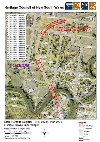
Lismore railway underbridges is a heritage-listed group of railway-associated structures in Lismore, New South Wales, Australia erected for the 1894 creation of that section of the Murwillumbah railway line. This item was added to the New South Wales State Heritage Register on 2 April 1999. It comprises the steel frame Leycester Creek railway bridge that carries the railway over Leycester Creek, plus associated timber (trestle) structures that cross Union Street in South Lismore, and Terania Street and Alexander Parade in North Lismore. As at October 2023, the Leycester Creek railway bridge was closed to the public for safety reasons while the Terania Street crossing, normally open to vehicular traffic, was temporarily closed to allow maintenance work to be carried out.
References
- ↑ "Fact sheet: Northern Rivers Rail Trail" (PDF). Northern Rivers Rail Trail. 1 January 2023.
- 1 2 "Northern Rivers Rail Trail | The must-do experience in the region". Northern Rivers Rail Trail. Retrieved 25 June 2024.
- 1 2 3 "Northern Rivers Rail Trail". www.tweed.nsw.gov.au. Retrieved 25 June 2024.
- ↑ "Closure of Casino to Murwillumbah Rail Services". www.parliament.nsw.gov.au. Retrieved 25 June 2024.
- ↑ "Bridges and tunnels". Northern Rivers Rail Trail. Retrieved 25 June 2024.
- ↑ "Top tips for exploring the new Rail Trail". www.tweed.nsw.gov.au. Retrieved 25 June 2024.
- ↑ "Burringbar Range Tunnel". www.nswrail.net. Retrieved 25 June 2024.
- ↑ "Northern Rivers Rail Trail – Rail Trails Australia". 23 April 2024. Retrieved 25 June 2024.
- 1 2 3 "Project and construction". Northern Rivers Rail Trail. Retrieved 25 June 2024.
- ↑ "Northern Rivers Rail Trail – Lismore to Bentley section". Your Say Lismore. Retrieved 25 June 2024.
- ↑ "Northern Rivers Rail Trail - Byron Shire". www.byron.nsw.gov.au. Retrieved 25 June 2024.