Northfield railway line

Last updated

Northfield railway line
Northfield Line.gif
Overview
Locale Adelaide, South Australia
Termini
History
Opened1 June 1857
Closed1987
Technical
Line length14.3 km (8.9 mi)
Number of tracksQuadruple track to Torrens Junction
Double track to Dry Creek
Closed from Dry Creek
(formerly single track)
Route map

Contents

BSicon exKHSTa.svg
14.9
Stockade
BSicon exHST.svg
Northfield (original site)
1857–1961
BSicon exBUE.svg
Briens Road
BSicon exBHF.svg
14.3
Northfield
1961–87
BSicon exBUE.svg
BSicon exdKDSTa.svg
BSicon exdBHF.svg
12.9
Pooraka
Abattoirs sidings
BSicon exBS2c1.svg
BSicon exABZg+l.svg
BSicon exSHI2g+r.svg
BSicon exdKDSTeq.svg
Metropolitan Abattoirs
BSicon exHST.svg
12.1
Cavan
BSicon exBUE.svg
BSicon exBUE.svg
Churchill Road North
BSicon dCONTgq.svg
BSicon eABZqlr.svg
BSicon BHFq.svg
BSicon dCONTfq.svg
Dry Creek

The Northfield railway line (formerly Stockade railway line) was a railway in northern Adelaide running Dry Creek and Northfield. The line branched east from the Gawler railway line just north of Dry Creek station. In earlier years, it saw mixed freight including livestock in and meat out of the Gepps Cross abattoirs and sale yards. In its later years, it was operated as part of the metropolitan passenger rail network and served three stations: Cavan, Pooraka, and Northfield.

History

The Stockade line (originally terminating at Stockade railway station) was opened on 1 June 1857 [1] at the same time as the Adelaide-Smithfield section of what is now the Gawler line, making it one of South Australia's oldest rail lines. It was built to carry stone from the quarries behind Yatala Labour Prison. [2] [3] Originally intended only for a freight role, in the 19th century the line also catered for passenger traffic. When the Metropolitan and Export Abattoirs Board was formed in 1933, it transferred more slaughter work to Gepps Cross, and a new siding named Export Siding was built in 1937 to deliver sheep and lambs direct to the abattoirs. [4]

Map of the route of the Northfield branch Route of the former South Australian Railways Northfield branch.tif
Map of the route of the Northfield branch

Closure

The terminus station, Stockade, was closed in 1961; the line was cut back to Northfield station and the surplus land was sold. The last passenger trains to Northfield ran in 1987. [2] Livestock continued to be delivered by rail to the Gepps Cross Abattoirs and Livestock Markets sale-yards until 1995. [2] The stations were subsequently demolished and the track was lifted. An 18-metre section of the historic double-headed rail and chairs, used on the far eastern end of the Northfield Line, was recovered for display in the main pavilion at the National Railway Museum, Port Adelaide. [5]

The triangle junction where the track joined to the Gawler line was used by TransAdelaide as a storage area for rails, sleepers and maintenance equipment until 2009. After an announcement that a new railcar depot would be built at Dry Creek to replace the depot on the southern side of Adelaide station yard, the triangle was removed. That project also took over the site of the former Australian Railway Historical Society depot, which had been vacated in 1995.

The dual gauge track from the triangle junction north to Dry Creek North Yard, which ran through former sheep-loading facilities, was leased by TransAdelaide to Genesee & Wyoming Australia for storage of some standard gauge rolling stock before construction of the new railcar depot. The former siding and sheep loading facilities became part of the new depot complex. After the line was closed, services which previously operated from Adelaide to Northfield were cut back to terminate at Dry Creek. They ceased operating in 2008.

In 2019, overgrown remains of Cavan railway station, Pooraka railway station and the rail corridor between Cavan and Pooraka, were all that remained of the line. Between Dry Creek and Cavan the line has been built over; some concrete Train Control telephone cabins still stood on the side of Churchill Road North.

Line guide

Map all coordinates using: OpenStreetMap
StationImageOpenedCoordinatesAdditional information
Stockade 1 June 1857 34°50′29″S138°37′43″E / 34.8415°S 138.6286°E / -34.8415; 138.6286 (Stockade) Terminus 1857–1961; closed in July 1961
Northfield 1857

34°50′22″S138°37′24″E / 34.83953°S 138.62325°E / -34.83953; 138.62325 (Northfield)

Terminus 1961–1987; moved west of Briens Road in 1961; closed 29 May 1987
Pooraka 12 July 1913 34°50′08″S138°36′29″E / 34.8356°S 138.6080°E / -34.8356; 138.6080 (Pooraka) Originally named Abattoirs station; closed 29 May 1987; sidings used until 1995
Cavan 1914 34°50′02″S138°35′59″E / 34.8339°S 138.5998°E / -34.8339; 138.5998 (Cavan) Closed 29 May 1987; sidings used until 1995
Dry Creek DryCreekRailwayStationAdelaide.jpg 1856 34°50′06″S138°35′08″E / 34.83500°S 138.58556°E / -34.83500; 138.58556 (Dry Creek) Former branch station; still in use as part of the Gawler line.

Related Research Articles

<span class="mw-page-title-main">Adelaide railway station</span> Railway station in Adelaide, South Australia

Adelaide railway station is the central terminus of the Adelaide Metro railway system. All lines approach the station from the west, and it is a terminal station with no through lines, with most of the traffic on the metropolitan network either departing or terminating here. It has nine below-ground platforms, all using broad gauge track. The station is located on the north side of North Terrace, west of Parliament House.

<span class="mw-page-title-main">Railways in Adelaide</span> Regional rail network

The rail network in Adelaide, South Australia, consists of four lines and 89 stations, totalling 132 km (82 mi). It is operated by Keolis Downer under contract from the Government of South Australia, and is part of the citywide Adelaide Metro public transport system.

<span class="mw-page-title-main">Dry Creek–Port Adelaide railway line</span> Railway line in Adelaide, South Australia

The Dry Creek–Port Adelaide railway line is an eight-kilometre east–west freight railway line running through Adelaide's north-western suburbs. The line is managed by the Australian Rail Track Corporation (ARTC) and is an important link between Port Adelaide, Pelican Point and the main interstate rail routes which link Adelaide with Melbourne, Perth, Darwin and Sydney. Prior to 1988, a limited local passenger service operated, stopping at five intermediate stations along the line. Since May 1988, the line has been freight-only.

<span class="mw-page-title-main">Gawler line</span> Commuter railway line in Adelaide, South Australia

The Gawler line, also known as the Gawler Central line, is a suburban commuter railway line in the city of Adelaide, South Australia. The Gawler Line is the most frequent and heavily patronised line in the Adelaide rail network.

<span class="mw-page-title-main">Cavan, South Australia</span> Suburb of Adelaide, South Australia

Cavan is a suburb north of Adelaide, within the City of Salisbury local government area.

<span class="mw-page-title-main">Northfield, South Australia</span> Suburb of Adelaide, South Australia

Northfield is a suburb of the greater Adelaide, South Australia area.

<span class="mw-page-title-main">Dry Creek railway station</span> Railway station in Adelaide, South Australia

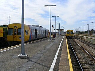
Dry Creek railway station is located on the Gawler line. Situated in the inner northern Adelaide suburb of Dry Creek, it is 10.6 kilometres (6.6 mi) from Adelaide station.

<span class="mw-page-title-main">State Transport Authority (South Australia)</span> Agency responsible for public transport in South Australia

The State Transport Authority (STA) was the government agency which controlled public transport in South Australia between 1974 and 1994.

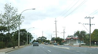
Grand Junction Road is the longest east–west thoroughfare in the Adelaide metropolitan area, traversing through Adelaide's northern suburbs approximately 8 kilometres north of the Adelaide city centre.

<span class="mw-page-title-main">2000 class railcar</span>

The 2000 class and 2100 class were diesel multiple units that operated on the Adelaide rail network between 1980 and 2015. They were built by Comeng in Granville, New South Wales in 1979–1980.

Pooraka railway station was located approximately 12.9 km by rail from Adelaide on the former 3.9 kilometres (2.4 mi) long Northfield branch line that opened in June 1857. The station opened as Abattoirs railway station on 12 July 1913, when the adjacent Gepps Cross Abattoirs also opened. The station's livestock sidings extended for most of the 970 metres of the line between Port Wakefield Road and the Gawler Road.

Northfield railway station was located 14.3 km (9 mi) from Adelaide station.

The Barossa Valley railway line is a railway line with several branches, running from Gawler into and through the Barossa Valley. The original terminus was at Angaston. A branch was built from Nuriootpa via Stockwell to Truro, and a further branch from that to Penrice. The Angaston and Truro branches are closed and removed; the line to Penrice remains but has not been used since 2014.

The Adelaide–Port Augusta railway line is the main route for northbound rail traffic out of Adelaide, South Australia. The line, 315 kilometres long, is part of the Adelaide–Darwin rail corridor and the Sydney–Perth rail corridor.

<span class="mw-page-title-main">Pooraka, South Australia</span> Suburb of Adelaide, South Australia

Pooraka is a suburb in Adelaide, South Australia. It is 12 km (7.5 mi) north of the central business district.

<span class="mw-page-title-main">Adelaide Metro 4000 class</span> Class of electric multiple unit trains

The Adelaide Metro 4000 class, also referred to as A-City trains, are electric multiple unit trains built by Bombardier Transportation in Dandenong, Victoria for the electrified Adelaide rail network. They are the only class of operational electric trains in South Australia, running services on the Gawler, Seaford and Flinders lines.

<span class="mw-page-title-main">Port Pirie railway station (Mary Elie Street)</span> One of Port Piries six railway stations, in operation from 1967 to 1989

Port Pirie railway station (Mary Elie Street) was the fifth of six railway stations for passengers that operated at various times from 1876 to serve the small maritime town (later city) of Port Pirie, 216 kilometres (134 miles) by rail north of Adelaide, South Australia. As with several of Port Pirie's other stations before it, the station was built to accommodate a change of track gauge on railway lines leading into the town.

Cavan railway station was located 12.1 kilometres (7.5 mi) by rail from Adelaide on the now closed Northfield branch line. Its elevation was 13 metres (43 ft) above sea level.

The Stockade railway station, the terminal station of the then Stockade railway line, was opened on 1 June 1857. It was built to service the colony's prisoner camp, and to transport bluestone mined by convicts to building projects in downtown Adelaide. After a century of service, it was closed in 1961, and the quarry area was later redeveloped as a park.

References

  1. "Railways Have Earned £154 M. In 90 Years". The Advertiser (Adelaide) . South Australia. 20 March 1947. p. 17 (The Advertiser (Adelaide, SA : 1889–1931)). Retrieved 2 May 2019 via National Library of Australia.
  2. 1 2 3 A Brief History of the Dry Creek to Stockade Railway Catch Point issue 179 May 2007 pages 27–29
  3. "Dry Creek River Trails | Dry Creek Linear Park | Walking SA". Walking SA. Retrieved 20 September 2017.
  4. Richard Maurovic (2007). The Meat Game: A History of the Gepps Cross Abattoirs and Livestock Markets. Wakefield Press. p. 59. ISBN   978-1-86254-726-1.
  5. "150th Anniversary of the Stockade (Northfield) Line (A Brief History of the Dry Creek to Stockade Railway)". Catchpoint. May 2007. Retrieved 18 March 2015.