
Salem is the capital of the U.S. state of Oregon, and the county seat of Marion County. It is located in the center of the Willamette Valley alongside the Willamette River, which runs north through the city. The river forms the boundary between Marion and Polk counties, and the city neighborhood of West Salem is in Polk County. Salem was founded in 1842, became the capital of the Oregon Territory in 1851, and was incorporated in 1857.

Oregon City is the county seat of Clackamas County, Oregon, United States, located on the Willamette River near the southern limits of the Portland metropolitan area. Established in 1829 by the Hudson's Bay Company, in 1844 it became the first U.S. city west of the Rocky Mountains to be incorporated.
Molalla is a city in Clackamas County, Oregon. The population was 8,108 at the time of the 2010 census.

Keizer is a city located in Marion County, Oregon, United States, along the 45th parallel. As of the 2010 United States Census, its population was 36,478. It lies in the Willamette Valley and is part of the Salem Metropolitan Statistical Area. It was named after pioneer Thomas Dove Keizur and his family who arrived in the Wagon Train of 1843, and later filed donation land claims.
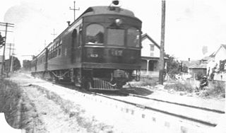
The Oregon Electric Railway (OE) was an interurban railroad line in the U.S. state of Oregon that linked Portland to Eugene. Service from Portland to Salem began in January 1908. The Spokane, Portland and Seattle Railway purchased the system in 1910, and extended service to Eugene in 1912. Regular passenger service in the Willamette Valley ended in May 1933. Freight operations continued and the railway survived into the 1990s, ultimately as a Burlington Northern feeder. Operation as an electric railroad ended July 10, 1945.

Chemawa Indian School is a Native American boarding school in Salem, Oregon, United States. Named after the Chemawa band of the Kalapuya people of the Willamette Valley, it opened on February 25, 1880 as an elementary school. Grades were added and dropped, and it became a fully accredited high school in 1927, when lower grades were dropped. In 2005, it continued to serve ninth through twelfth grades. It is sometimes referred to as Chemawa High School. It has primarily served students of tribes from the Pacific Northwest and Alaska.
Oregon Route 99E Business is a business route through Salem, Oregon for Oregon Route 99E, which bypasses downtown via Interstate 5 (I-5). A portion of this highway was originally planned to be a freeway, signed as Interstate 305; however the proposed freeway was cancelled after community opposition.

Oregon Route 213 is an Oregon state highway that serves the eastern Willamette Valley between Portland and Salem. It is a north–south route. The route is known as the Cascade Highway, though specific segments are generally better known by more localized names.

Maplewood is a suburban neighborhood in Southwest Portland, Oregon, United States.
Lake Grove is a neighborhood of Lake Oswego, Oregon, United States, located west of Oswego Lake, south of the Mountain Park neighborhood, east of Interstate 5, and north of Rivergrove.
Brentwood-Darlington is a neighborhood on the southern edge of Portland, Oregon, bordering SE 45th Avenue to the west, SE Duke Street to the north, and SE 82nd Avenue to the east. The county line separating Multnomah County from Clackamas County forms most of the neighborhood's southern boundary, though small portions of the neighborhood and the city extend into Clackamas County. Roughly, the southern boundary is SE Harney Drive on the eastern one-fourth, and SE Clatsop Street on the other three-quarters.

West Salem is a neighborhood in Salem, Oregon, United States, located in the far northwest part of the city. West Salem is the only part of the city that is located in Polk County. The neighborhood is separated from the rest of Salem by the Willamette River, which serves as West Salem's southeast border. The business districts of West Salem are located on Edgewater Street and Wallace Road. As of 2012, the portion of Salem within Polk County had a population of 24,183.
Lansing is a neighborhood in Salem, Oregon, United States, located in the northeast part of the city. The neighborhood is bordered on the north by Silverton Road, on the south by Market Street, on the east by Hawthorne Avenue, and on the west by Evergreen Avenue.
South Burlingame is a neighborhood in the Southwest section of Portland, Oregon. It is bordered by Multnomah to the west, Hillsdale and South Portland to the north, River View Cemetery to the east, and Markham, Marshall Park, and Collins View to the south.
Portsmouth is a neighborhood in the north section of Portland, Oregon, United States. It is bordered by Columbia Boulevard to the north, Lombard Street to the south, Chautauqua Boulevard to the east, and a BNSF Railway cut to the west.

Roberts High School is a high school in Salem, Oregon, United States. It provides non-traditional educational programs in the Salem-Keizer School District. Rather than a centralized campus, Roberts High School consists of departments at different sites in Salem and Keizer. These branch sites include the Downtown Learning Center, Structured Learning Center, Bridge, and Internet-based SK Online. In the 2006-2007 school year, over 1,000 students were enrolled in Roberts High School.
Salem-Keizer School District (24J) is a school district in the U.S. state of Oregon that serves the cities of Salem and Keizer. It is the second-largest school district in the state with more than 40,000 students and nearly 4,000 full-time equivalent (FTE) employees. It serves more than 172 square miles (450 km2) of Marion and Polk counties.
Interstate 5 (I-5) in the U.S. state of Oregon is a major Interstate Highway that traverses the state from north to south. It travels to the west of the Cascade Mountains, connecting Portland to Salem, Eugene, Medford, and other major cities in the Willamette Valley and across the northern Siskiyou Mountains. The highway runs 308 miles (496 km) from the California state line near Ashland to the Washington state line in northern Portland, forming the central part of Interstate 5's route between Mexico and Canada.
Rosedale is an unincorporated community in Marion County, Oregon. It is located just south of Salem in the Salem Hills. It is a part of the Salem Metropolitan Statistical Area. Rosedale post office ran from 1892 to 1901. The Rosedale area was a major prune growing region in the early 20th century but is now primarily made up of rural residential properties Vineyards and Christmas tree fields. Rosedale Elementary School located at 6974 Bates Road Salem, Oregon was in service from 1893 until its closing in 2012.
Faye Wright is a neighborhood in Salem, Oregon, United States, located in the southeast part of the city. The neighborhood is bordered on the east by Commercial Street SE, on the west by Liberty Road S, and on the south by Kuebler Boulevard SE. Faye Wright has a population of 2,672.