Related Research Articles
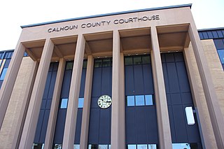
Calhoun County is a county located in the U.S. state of Florida. As of the 2020 census, the population was 13,648, making it the fifth-least populous county in Florida. Its county seat is Blountstown.

Jackson County is a county located in the U.S. state of Florida, on its northwestern border with Alabama. As of the 2020 census, the population was 47,319. Its county seat is Marianna.

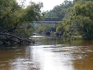
The Apalachicola River is a river, approximately 160 miles (260 km) long, in the state of Florida. The river's large watershed, known as the Apalachicola, Chattahoochee and Flint (ACF) River Basin, drains an area of approximately 19,500 square miles (50,500 km2) into the Gulf of Mexico. The distance to its farthest head waters in northeast Georgia is approximately 500 miles (800 km). Its name comes from Apalachicola Province, an association of Native American towns located on what is now the Chattahoochee River. The Spanish included what is now called the Chattahoochee River as part of one river, calling all of it from its origins in the southern Appalachian foothills down to the Gulf of Mexico the Apalachicola.

The Florida panhandle is the northwestern part of the U.S. state of Florida. It is a salient roughly 200 miles (320 km) long, bordered by Alabama on the north and the west, Georgia on the north, and the Gulf of Mexico to the south. Its eastern boundary is arbitrarily defined. It is defined by its southern culture and rural geography relative to the rest of Florida, as well as closer cultural links to French-influenced Louisiana, Mississippi, and Alabama. Its major communities include Pensacola, Navarre, Destin, Panama City Beach, and Tallahassee.
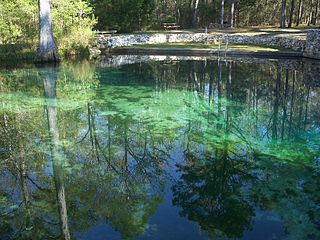
Ponce de Leon Springs State Recreation Area is a Florida State Park in Holmes County, Florida, USA. It is located in the town of Ponce de Leon. The park, which was created to provide public outdoor recreation and other park-related uses, was initially acquired on September 4, 1970, using funds from the Land Acquisition Trust Fund. Its self-proclaimed purpose is to develop, operate and maintain the property for outdoor recreation, park, historic, and related purposes, offering abundant opportunity for nature appreciation and wildlife viewing. Its primary recreational activities include swimming in the spring and hiking along the park's nature trails.

The Choctawhatchee River is a 141-mile-long (227 km) river in the southern United States, flowing through southeast Alabama and the Panhandle of Florida before emptying into Choctawhatchee Bay in Okaloosa and Walton counties. The river, the bay and their adjacent watersheds collectively drain 5,350 square miles (13,900 km2).

The Apalachicola National Forest is the largest U.S. National Forest in the state of Florida. It encompasses 632,890 acres and is the only national forest located in the Florida Panhandle. The National Forest provides water and land-based outdoors activities such as off-road biking, hiking, swimming, boating, hunting, fishing, horse-back riding, and off-road ATV usage.

Apalachicola Bay is an estuary and lagoon located on the northwest coast of the U.S. state of Florida. The Apalachicola Bay system also includes St. George Sound, St. Vincent Sound and East Bay, covering an area of about 208 square miles (540 km2). Four islands, St. Vincent Island to the west, Cape St. George Island and St. George Island to the south, and Dog Island to the east, separate the system from the Gulf of Mexico. Water exchange occurs through Indian Pass, West Pass, East Pass and the Duer Channel. The lagoon has been designated as a National Estuarine Research Reserve and the Apalachicola River is the largest source of freshwater to the estuary. Combined with the Chattahoochee River, Flint River, and Ochlockonee River they drain a watershed of over 20,000 square miles (50,000 km2) at a rate of 19,599 cubic feet per second according to the United States Geological Survey in 2002.

The Florida Trail is one of eleven National Scenic Trails in the United States, created by the National Trails System Act of 1968. It runs 1,500 miles (2,400 km), from Big Cypress National Preserve to Fort Pickens at Gulf Islands National Seashore, Pensacola Beach. Also known as the Florida National Scenic Trail, the trail provides permanent non-motorized recreation for hiking and other compatible activities within an hour's drive of most Floridians.
The Ochlockonee River is a fast running river, except where it has been dammed to form Lake Talquin in Florida, originating in Georgia and flowing for 206 miles (332 km) before terminating in Florida.

The bluenose shiner is a species of freshwater fish in the family Cyprinidae. It is found only in the United States, mostly in Florida and parts of Alabama and Georgia; its habitat is deep, slow-moving coastal creeks and small to medium rivers and prefers deep pools than shallow areas.
The following is an alphabetical list of articles related to the U.S. state of Florida.
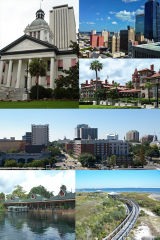
North Florida is a region of the U.S. state of Florida comprising the northernmost part of the state. Along with South Florida and Central Florida, it is one of Florida's three most common "directional" regions. It includes Jacksonville and nearby localities in Northeast Florida, an interior region known as North Central Florida, and the Florida Panhandle. North Florida is considered to be part of the Southern United States.
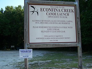
Econfina Creek is a small river in the middle Florida Panhandle. It flows through hilly country, and has sections of whitewater rapids. Much of its flow comes from springs. The river ends at Deer Point Lake, a reservoir that provides the freshwater supply for Panama City and much of Bay County.

Tropical Depression Six caused significant flooding along the Gulf Coast of the United States, especially in the Florida Panhandle. The sixth tropical cyclone of the 1975 Atlantic hurricane season, the depression developed from a trough of low pressure in the northeastern Gulf of Mexico on July 28. The system strengthened slightly, but peaked with maximum sustained winds of 35 mph (56 km/h) – below tropical storm intensity. Early on July 29, the depression made landfall in eastern Louisiana. Once inland, the depression slowly weakened and re-curved northeastward on July 30 into Mississippi, shortly before degenerating into a remnant low pressure area. The remnants moved through northern Louisiana and Arkansas until dissipating on August 3.
The five water management districts in Florida are:
The Surface Water Improvement and Management Act of 1987 was a law passed by the Florida Legislature in order to protect surface waters of, which include estuaries, rivers, lakes, and streams. The act created the Surface Water Improvement and Management Program, which seeks to control nonpoint source pollution.
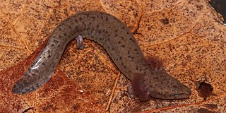
The Apalachicola waterdog is a species of aquatic salamander in the family Proteidae. It is endemic to the south-eastern United States.
References
- 1 2 Land & Recreation tab Land and Recreation, Northwest Florida Water Management District website
- ↑ Lands Northwest Water Management District website