
The Chattahoochee River forms the southern half of the Alabama and Georgia border, as well as a portion of the Florida - Georgia border. It is a tributary of the Apalachicola River, a relatively short river formed by the confluence of the Chattahoochee and Flint rivers and emptying from Florida into Apalachicola Bay in the Gulf of Mexico. The Chattahoochee River is about 430 miles (690 km) long. The Chattahoochee, Flint, and Apalachicola rivers together make up the Apalachicola–Chattahoochee–Flint River Basin. The Chattahoochee makes up the largest part of the ACF's drainage basin.

The Suwannee River is a river that runs through south Georgia southward into Florida in the southern United States. It is a wild blackwater river, about 246 miles (396 km) long. The Suwannee River is the site of the prehistoric Suwanee Straits which separated peninsular Florida from the panhandle.
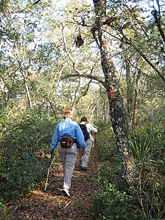
The Florida Trail is one of eleven National Scenic Trails in the United States. It currently runs 1,000 miles (1,600 km), with 300 miles (480 km) planned, from Big Cypress National Preserve to Fort Pickens at Gulf Islands National Seashore, Pensacola Beach. Also known as the Florida National Scenic Trail, the Florida Trail provides permanent non-motorized recreation opportunity for hiking and other compatible activities and is within an hour of most Floridians. The Florida National Scenic Trail is designated as a National Scenic Trail by the National Trails System Act of 1968.
The Tampa Bypass Canal and Palm River are a 14-mile-long (23 km) flood bypass operated by the Southwest Florida Water Management District. The canal includes several concrete flood control structures and was constructed during the 1960s and 1970s. Its purpose is to redirect flood waters from large amounts of rainfall from the Hillsborough River to Tampa Bay to prevent floodwaters reaching homes and businesses. Despite its original purpose it is now used as a drinking water source for the City of Tampa. During construction of the canal the Floridan aquifer was accidentally breached.
The Southwest Florida Water Management District, is one of five regional agencies directed by Florida state law to protect and preserve water resources. Established in 1961 the agency operates and maintains several large properties and flood protection projects, sometimes with other agencies. The District's responsibilities have expanded to include managing water supply and protecting water quality and the natural systems — rivers, lakes, wetlands and associated uplands.The District's stated mission is to protect water resources, minimize flood risks and ensure the public’s water needs are met.

The Santa Fe River is a 75-mile (121 km) river in northern Florida. The watershed of the river is approximately 1,380 square miles (3,574 km2) and spreads across southern Columbia, southern Suwannee, western Bradford, far southern Baker, Union, northern and eastern Gilchrist, and northern Alachua counties. The headwaters of the river are Lake Santa Fe, near Keystone Heights. The Santa Fe River is usually a slow-flowing river. This slow speed, combined with the abundant leaf-drop from nearby trees, especially Bald Cypress, leads to a very dark-brown river due to dissolved tannins.

The St. Johns River Water Management District ("SJRWMD") is one of five Florida water management districts that is responsible for managing groundwater and surface water resources in Florida. SJRWMD covers an 18-county region in northeast and east-central Florida.
The Northwest Florida Water Management District (NWFWMD) stretches from the St. Marks River Basin in Jefferson County to the Perdido River in Escambia County. The District is one of five water management districts in Florida created by the Water Resources Act of 1972. The District has worked for decades to protect and manage water resources in a sustainable manner for the continued welfare of people and natural systems across its 16-county region. It serves Bay, Calhoun, Escambia, Franklin, Gadsden, Gulf, Holmes, Jackson, Leon, Liberty, Okaloosa, Santa Rosa, Wakulla, Walton, Washington and western Jefferson County.

Fountain Creek is a stream that originates in Woodland Park in Teller County and flows through El Paso County to its confluence with the Arkansas River near Pueblo in Pueblo County, Colorado. The 74.5-mile-long (119.9 km) creek, once known as the Fontaine qui Bouille, is a tributary of the Arkansas River.
The Florida Department of Environmental Protection (FDEP) is the Florida government agency charged with environmental protection.

Colt Creek State Park is a Florida State Park in Central Florida, 16 miles (26 km) north of Lakeland off of State Road 471. This 5,067 acre park nestled within the Green Swamp Wilderness Area and named after one of the tributaries that flows through the property was opened to the public on January 20, 2007. Composed mainly of pine flatwoods, cypress domes and open pasture land, this piece of pristine wilderness is home to many animal species including the American bald eagle, Southern fox squirrel, gopher tortoise, white-tailed deer, wild turkey and bobcat.
The South Florida Water Management District (SFWMD) is a regional governmental district that oversees water resources from Orlando to the Florida Keys. The mission of the SFWMD is to manage and protect water resources by balancing and improving water quality, flood control, natural systems and water supply, covering 16 counties in Central and Southern Florida. It is the largest water management district in the state, managing water needs for 7.7 million residents. A key initiative is the restoration of America's Everglades – the largest environmental restoration project in the nation's history. The District is also working to improve the Kissimmee River and its floodplain, Lake Okeechobee and South Florida's coastal estuaries.

Bluestone Wildlife Management Area is a wildlife management area in southern West Virginia surrounding Bluestone Lake and the New River. The section of the lake from just upstream of the Bluestone River to Bluestone Dam is in Bluestone State Park; the rest of the lake in West Virginia basin comprises Bluestone WMA. All together, the WMA comprises 18,019 acres (72.92 km2) of land and water.

The Nature Coast State Trail (NCST) is a 31.7-mile long segment of Florida's Statewide System of Greenways and Trails System built along abandoned railroad tracks, and designated by the U.S. Department of the Interior as a National Recreation Trail. It has two primary sections following unused rail lines that were originally built by the Atlantic Coast Line Railroad. It includes historic sites such as an old train trestle bridge over the Suwannee River near Old Town and train stations in Trenton, Cross City, and Chiefland. At Wilcox Junction abandoned rail tracks cross and connect with several communities. The trail is available to hikers, cyclists, and horse riders.

Big Shoals State Forest is a protected area of 1,629 acres (659 ha) just east of White Springs, Florida and adjacent to Big Shoals State Park in Hamilton County. The state forest area comprises the north part of the 3,919-acre (1,586 ha) Big Shoals Public Lands and contains the largest area of whitewater in Florida. It is in the area of the Suwannee River.
Fish Hawk Creek Nature Preserve is a 3,286-acre (1,330 ha) nature preserve in Hillsborough County, Florida. The preserve is managed by Hillsborough County's Conservation and Environmental Lands Management Department and is located along the riparian corridor of FishHawk Creek, a significant tributary of the Alafia River. As a result, the acquisition and protection of the Fish Hawk Creek Nature Preserve has provided an essential link in assuring the long-term protection of a significant regional habitat corridor. Restoration projects have been initiated on the property. Habitats include pine flatwoods, sandhill, Florida scrub, and creek corridors. The preserve is bisected by FishHawk Blvd. and is identified by a north and a south section. The north section of the preserve includes a 2.2 mile hiking trail and can be accessed through Lithia Springs Regional Park in Lithia, Florida. The south portion of the preserve can be accessed through a parking area near the intersection of Boyette Rd. and Balm Rd. and includes a 2-mile hiking trail.

Steinhatchee Falls and Steinhatchee Rise are tracts of protected lands in Florida named for aquatic features. Steinhatchee Falls includes 1,766 acres (715 ha), and Steinhatchee Rise covers 3,559 acres (1,440 ha). Steinhatchee Falls is in southeastern Taylor County, Florida. Steinhatchee Rise is in southwestern Dixie County, Florida.
Suwannee Ridge Wildlife and Environmental Area (WEA) conserves 1,428 acres of longleaf pine uplands, karst topography and hardwood hammocks ten miles southwest of Jasper in Hamilton County, Florida.

Gulf Hammock is a wetlands area in the southern end of Levy County, Florida. It extends along the Gulf of Mexico coast from Cedar Key to the Withlacoochee River, and reaches several miles inland. Gulf Hammock includes the largest expanse of hydric hammock in Florida. The area is mostly uninhabited, with the area closest to the Gulf coast in a state park, and the inland areas primarily used for logging and hunting.
