Northwestern Switzerland

Last updated
Northwestern Switzerland
Nordwestschweiz
Region
Karte Nordwestschweiz 2013.2.png
Country Flag of Switzerland (Pantone).svg  Switzerland
Area
[1]
  Total
1,958.2 km2 (756.1 sq mi)
Population
 (2024) [2]
  Total
1,225,762
  Density630/km2 (1,600/sq mi)
GDP
[3]
  Total CHF 111.553 billion (2022)
NUTS codeCH03
HDI (2022)0.964 [4]
very high · 4th

Northwestern Switzerland (German : Nordwestschweiz, French : Suisse du Nord-Ouest, Italian : Svizzera nordoccidentale), is a subdivision of Switzerland as defined by the Federal Statistical Office for statistical purposes. It is classified as a NUTS-2 statistical region of Switzerland, and encompasses the cantons of Basel-Stadt, Basel-Landschaft, and Aargau. It is different from the traditional region of the same name (Nordwestschweiz in German), which also includes Basel-Stadt and Basel-Landschaft, certain northern parts of the Solothurn and only parts of the canton of Aargau.

Contents

Sub-division

The country of Switzerland is federally organized into 26 cantons, which are the primary sub-divisions of the country. [5] For statistical purposes, the Federal Statistical Office organizes the country into broader level sub-divisions based on cardinal directions. These are classified as a NUTS-2 statistical regions of Switzerland, and incorporate various cantons within it. [6] [7]

Geography

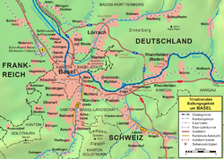
Northwestern Switzerland consists of the areas towards the north-western periphery of the country, bordering Grand Est of France to the west and Baden-Württemberg of Germany to the north. The Basel Trinational Eurodistrict extends across the three countries, in the area between the Rhine valley and the plain of Alsace. [8] The three countries meet in the middle of the Rhine River, slightly north of the Dreiländereck. [9] The region encompasses an area of 1,958.2 km2 (756.1 sq mi), [1] and had a population of over 1.22 million in 2024. [2]

Sub-divisions

It encompasses the cantons of Basel-Stadt, Basel-Landschaft, and Aargau. [7] It is different from the traditional region of the same name (Nordwestschweiz in German), which also includes Basel-Stadt and Basel-Landschaft, certain northern parts of the Solothurn and only parts of the canton of Aargau. [10] [11]

S.No. Arms
[a]
Code Name Established CapitalGDP (2020) [13]
in million CHF
GDP per
capita (2020) [14]
in CHF
Population
(2007)
Area (km2) Density
(per km2)
Municipalities (2018) [15] Official languages
1 Wappen Aargau matt.svg


AG Aargau 1803
[b]
Aarau 43,59063,177694,0721,404494212
2 Wappen Basel-Stadt matt.svg


BS Basel-Stadt 1501 (as Basel until 1999) Basel 37,168189,354201,156375,4443 German
3 Wappen Basel-Landschaft matt.svg


BL Basel-Landschaft 1501 (as Basel until 1999) Liestal 20,56770,866292,95551856686 German

Economy

Trinational Eurodistrict of Basel is one of the major industrial centers Grossraum Basel.png
Trinational Eurodistrict of Basel is one of the major industrial centers

The region is economically developed, [4] and Basel area is one of the major economic centers of the country. [8] [16] Major industries include pharmaceuticals, chemicals, and textiles. The economic development started in the early 1900s, when mineral deposits were found in the area. This led to setting up of various industries in Pratteln. The construction of the Hauenstein Railway between Basel and Olten furthered economic growth as it connected the region with the other parts of the country. Liestal serves as the center of the textile industries, and is one of the most industrialized towns in the region. [16]

Notes

  1. Cantonal coats of arms shown with cantonal heraldic colors (Standesfarben). Standesfarben were used to identify the (historical) cantons when the full banner was not available for display, although there is overlap; Unterwalden and Solothurn share the same colours, as do Basel and Appenzell, and with the accession of the modern cantons, Valais and Basel-City, and St. Gallen and Thurgau. [12]
  2. Act of Mediation; created from the cantons of Aargau (canton of the Helvetic Republic, from territory previously controlled by Bern) and Baden (previously a Swiss condominium), together with Fricktal (before 1802 not Swiss territory).

References

  1. 1 2 "Area by NUTS 3 regions - km2". Eurostat. Retrieved 1 June 2024.
  2. 1 2 "Population on 1 January by NUTS 2 region". Eurostat. Retrieved 1 June 2024.
  3. "Gross domestic product (GDP) per region and canton". www.bfs.admin.ch.
  4. 1 2 "Sub-national HDI - Area Database - Global Data Lab". hdi.globaldatalab.org.
  5. "Regional Portraits: Cantons". Federal Statistical Office . 2011. Archived from the original on 30 April 2009. Retrieved 21 December 2015.
  6. "NUTS classification". Eurostat. Retrieved 1 June 2024.
  7. 1 2 "NUTS regions". Eurostat. Retrieved 1 June 2024.
  8. 1 2 "Basel Trinational Eurodistrict". Transfrontaliers. Retrieved 1 June 2024.
  9. "Dreiländereck - Basel, Switzerland". Waymarking. Retrieved 24 June 2015.
  10. "La Suisse du Nord-Ouest compte parmi les régions les plus innovantes d'Europe" [Northwestern Switzerland is one of the most innovative regions in Europe]. Eco Jura (in French). 10 May 2021. Retrieved 1 June 2024.
  11. "North western Switzerland". SBPV. Retrieved 1 June 2024.
  12. Louis, Mühlemann, Wappen und Fahnen der Schweiz, 700 JahreConfoederatio Helvetica, Lengnau, 3rd ed. 1991. Swiss Armed Forces, Fahnenreglement, Reglement 51.340 d (2013). Archived 11 November 2020 at the Wayback Machine
  13. "Cantonal gross domestic product (GDP)". Federal Statistical Office . 12 November 2019. Retrieved 10 September 2021.
  14. "Cantonal gross domestic product (GDP) per capita". Federal Statistical Office . 12 November 2019. Retrieved 10 September 2021.
  15. "Gemeinden - Suche | Applikation der Schweizer Gemeinden". Swiss Federal Statistical Office (in German). Retrieved 22 October 2018.
  16. 1 2 "The Economoy of Northwestern Switzerland". SIH Vintes. Retrieved 1 June 2024.

47°25′41″N7°53′06″E / 47.42806°N 7.88500°E / 47.42806; 7.88500