Related Research Articles

The Pitts Special is a series of light aerobatic biplanes designed by Curtis Pitts. It has accumulated many competition wins since its first flight in 1944. The Pitts biplanes dominated world aerobatic competition in the 1960s and 1970s and, even today, remain potent competition aircraft in the lower categories.
Huron County Memorial Airport is a county-owned, public-use airport located one nautical mile (1.85 km) south of the central business district of Bad Axe, a city in Huron County, Michigan, United States. It is included in the Federal Aviation Administration (FAA) National Plan of Integrated Airport Systems for 2017–2021, in which it is categorized as a local general aviation facility.
Erie–Ottawa International Airport, is three miles east of Port Clinton, in Ottawa County, Ohio. It is owned by the Erie–Ottawa Airport Authority. The National Plan of Integrated Airport Systems for 2011–2015 categorized it as a general aviation facility. On November 9, 2013, Erie–Ottawa Airport obtained approval to handle international flights.

Ohio State University Airport is a public airport six miles (10 km) northwest of downtown Columbus, in Franklin County, Ohio, United States. It is owned and operated by Ohio State University in Columbus. It is also known as the OSU Don Scott Airport, named after Donald E. Scott, an OSU alumnus who died during his training as a pilot in the United Kingdom during World War II. The airport's main entrance is located on Case Road, and is easily accessible from OH-315 and Interstate 270.
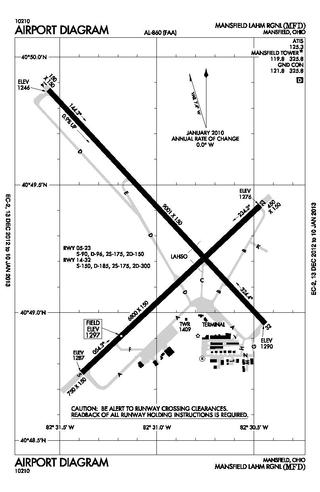
Mansfield Lahm Regional Airport is three miles (5 km) north of Mansfield, in Richland County, Ohio. By car the airport is an hour away from Cleveland and Columbus, near Interstate I-71, US Rt 30, State Route 13.

Springfield–Beckley Municipal Airport is a civil-military airport five miles (8 km) south of Springfield, in Clark County, Ohio, United States. It is owned by the city of Springfield. It is named after the Beckley family, a member of which knew the Wright Brothers, and witnessed and photographed their first flights.
Ohio University Airport or Gordon K. Bush Airport, also known as Snyder Field, is a public-use airport located on State Route 32/U.S. 50 in the village of Albany, about ten miles (16 km) southwest of the city of Athens, in Athens County, Ohio, United States.
Branch County Memorial Airport is a county-owned, public-use airport located three nautical miles (6 km) west of the central business district of Coldwater, a city in Branch County, Michigan, United States. It is included in the Federal Aviation Administration (FAA) National Plan of Integrated Airport Systems for 2017–2021, in which it is categorized as a local general aviation facility.
Portage County Airport, also known as Portage County Regional Airport, is a public use airport in Portage County, Ohio, United States. It is owned by the Portage County Airport Authority and located three nautical miles (6 km) north of Ravenna, in Shalersville Township. This airport is included in the National Plan of Integrated Airport Systems for 2011–2015, which categorized it as a general aviation facility.

Nancy A. Lynn was an aerobatic pilot, flight instructor, and air show performer. She owned and operated Lynn Aviation, an aerobatic flight school located at Bay Bridge Airport in Stevensville, Maryland, with her husband Scott Muntean and son Pete.
Newark–Heath Airport is a public airport located in Heath, Ohio. It is three miles (4.8 km) southwest of the central business district of Newark, a city in Licking County, Ohio, United States. The airport was opened in 1930 by the city of Newark, and was transferred to the Licking County Regional Airport Authority in 1967. The airport currently has a McDonnell Douglas F-4C Phantom II S.N. 64–0683 on static display.

Union County Airport is a public use airport in Union County, Ohio, United States. It is owned by the Union County Airport Authority and located one nautical mile (2 km) southeast of the central business district of Marysville, Ohio. This airport is included in the National Plan of Integrated Airport Systems for 2011–2015, which categorized it as a general aviation facility.
Lake County Executive Airport, formerly Lost Nation Airport, is a public use airport in Lake County, Ohio, United States. Located approximately 3 miles (5 km) north-northeast of the central business district of the City of Willoughby, it was owned and operated by that city until October 8, 2014, when it was transferred to Lake County and the Lake County Port and Economic Development Authority. The airport's name was changed from Lost Nation Airport to Lake County Executive Airport, alternately "Lake County Executive Airport at Lost Nation Field," in March 2020.
Medina Municipal Airport is a public use airport in Medina County, Ohio, United States. It is owned by the City of Medina and is located four nautical miles (7.41 km) east of the city's central business district. According to the FAA's National Plan of Integrated Airport Systems for 2007-2011, it is categorized as a reliever airport.
Highland County Airport is a public-owned, public-use airport located at 9500 North Shore Drive three nautical mile (4.8 km) southeast of the central business district of the city of Hillsboro, in Highland County, Ohio, United States.
Carroll County–Tolson Airport is a county–owned, public-use airport located one nautical mile (1.85 km) southeast of the central business district of Carrollton, a village in Carroll County, Ohio, United States. It is owned by the Carroll County Airport Authority. According to the FAA's National Plan of Integrated Airport Systems for 2009–2013, it is categorized as a general aviation airport.

Geauga County Airport, is a public use airport in southern Geauga County, Ohio, United States. Owned and operated by Geauga County since 1968, it serves all of Geauga County. The airport is located 40 nautical miles east of downtown Cleveland.
Richard Downing Airport is a public use airport located three nautical miles north of Coshocton, Ohio.
Holmes County Airport is a public airport located two miles southwest of Millersburg, Ohio, United States. It is owned and operated by the Holmes County Airport Authority.
Pickaway County Memorial Airport is a publicly-owned, public-use airport located 5 miles south of Circleville, Ohio. The airport sits on 61 acres at an elevation of 684 feet.
References
- 1 2 3 "AirNav: 5A1 - Norwalk-Huron County Airport". www.airnav.com. Retrieved 2024-02-02.
- 1 2 3 "5A1 - Norwalk-Huron County Airport | SkyVector". skyvector.com. Retrieved 2024-02-02.
- ↑ "Firelands Aero Club". Firelands Aero Club. Retrieved 2024-02-02.
- ↑ "Food Truck Fly-In postponed". norwalkreflector.com. Retrieved 2024-02-07.
- ↑ "Huron County Airport (5A1), Norwalk, Ohio". Kathryn's Report. Retrieved 2024-02-02.
- ↑ Gott, Brian. "Airport plan hoping to take off". Norwalk Reflector. Retrieved 2024-02-02.
- ↑ "Huron County Airport FBO Info & Fuel Prices at Norwalk-Huron County (5A1)". FlightAware. Retrieved 2024-02-02.
- ↑ "'We're trying to make this airport work': Norwalk-Huron County Airport (5A1), Ohio". Kathryn's Report. Retrieved 2024-02-02.
- ↑ Gott, Brian. "Airport to get runway renovations". Norwalk Reflector. Retrieved 2024-02-02.
- ↑ "Brown Announces Nearly $3 Million for Airport Improvements Across Northeast Ohio | U.S. Senator Sherrod Brown of Ohio". www.brown.senate.gov. Retrieved 2024-02-02.
- ↑ "Guy PITTS S-1S crash in Ohio (N2118) | PlaneCrashMap.com". planecrashmap.com. Retrieved 2024-02-02.