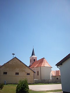
Novi Senkovac | |
|---|---|
Village | |
| Country | |
| County | |
| Town | Slatina |
| Population (2011) [1] | |
| • Total | 301 |
| Time zone | UTC+1 (CET) |
| • Summer (DST) | UTC+2 (CEST) |
Novi Senkovac is a village in Croatia. It is connected by the D34 highway.
Novi Senkovac | |
|---|---|
Village | |
| Country | |
| County | |
| Town | Slatina |
| Population (2011) [1] | |
| • Total | 301 |
| Time zone | UTC+1 (CET) |
| • Summer (DST) | UTC+2 (CEST) |
Novi Senkovac is a village in Croatia. It is connected by the D34 highway.

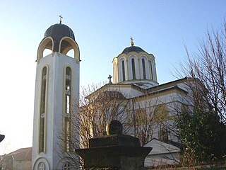
Slatina is a town in the Slavonia region of Croatia. It is located in the Virovitica-Podravina County, at the contact of the Drava valley and the foothills of Papuk mountain, in the central part of the region of Podravina, 29 km (18 mi) southeast of Virovitica; elevation 127 metres. It was ruled by Ottoman Empire between 1542 and 1687, when it was captured by Austrian troops. During Ottoman rule it was initially part of Sanjak of Pojega between 1542 and 1601, latterly part of Sanjak of Rahoviçe between 1601 and 1687. It was district centre at Virovitica County in Kingdom of Croatia-Slavonia between 1868 and 1918.

Primorje-Gorski Kotar County is a county in western Croatia that includes the Bay of Kvarner, the surrounding Northern Croatian Littoral, and the mountainous region of Gorski kotar. Its center is Rijeka. The county's population was 296,195 at the 2011 census.

Novi Marof is a town in north-western Croatia, located south of Varaždin and east of Ivanec, in the Varaždin County. It lies on intersection of state roads D3 and D24 and is also connected with highway A4, state road D22 and R201 railway.

Crikvenica is a city in Croatia, located on the Adriatic in the Primorje-Gorski Kotar County.

Novi Zagreb – istok is a district in Zagreb, Croatia. Within this district in the neighborhood of Travno lies Mamutica, which was built to be the largest communal housing block in southeast Europe. Mamutica towers above other blocks of flats so that the impression is given that it must be on a hill even though the entire area is a flat plain.

Stara Gradiška is a village and a municipality in Slavonia, in the Brod-Posavina County of Croatia. It is located on the left bank of the river Sava, across from Gradiška in Bosnia and Herzegovina.

Trnje is a district in the City of Zagreb, Croatia. According to the 2011 census, the district had 42,282 residents. It is located in the central part of the city, south of Donji grad across the railway, east of Trešnjevka, west of Peščenica, and north of the river Sava. The Slavonska Avenue intersects Trnje.

Novi Zagreb – zapad has the status of a city district in Zagreb, Croatia and as such has an elected council.

Donja Dubrava is one of the districts of Zagreb, Croatia. It is located in the northeastern part of the city and in 2011 had 36,363 inhabitants.
Novi Slankamen is a village in Serbia. It is located in the municipality of Inđija, Syrmia District, Autonomous Province of Vojvodina. Novi Slankamen is situated about 15 kilometers east of Inđija, on the bank of Danube (Dunav) and has a total population of 3,421.

Novi Vinodolski is a town on the Adriatic Sea coast in Croatia, located south of Crikvenica, Selce and Bribir and north of Senj. The population of Novi is 3,988, with a total of 5,131 people in the city administered area. The city area became a Frankopan property in the 13th century, marking the period to which the most valuable heritage is dated, including the Law codex of Vinodol. City hinterland is dominated by the Vinodol Valley, used for agriculture and winemaking. The city's economy is dominated by tourism, as Novi Vinodolski is well known tourist centre situated in an area largely unaffected by other types of industry and it offers a wide variety of tourist amenities. The Vinodol Valley is also the site of a hydroelectric power plant utilizing water collected in Gorski Kotar reservoirs. Transport links of the city are substantially dependent on the nearby city of Rijeka.
Barilović is a village and a municipality in central Croatia, in the Karlovac County.
Sveti Ivan Žabno is a municipality in the Koprivnica-Križevci County in Croatia. According to the 2011 census, there are 5,222 inhabitants in the area.

Srpski Miletić is a village located in the Odžaci municipality, West Bačka District, Vojvodina, Serbia. As of 2011, the village has 3,038 people inhabitants.

Ležimir is a village in Serbia. It is located in the Sremska Mitrovica municipality, in the Srem District, Vojvodina province. The village has a Serb ethnic majority and its population numbers 947 people.
Lučko is a settlement and a division of the Novi Zagreb - zapad district of the City of Zagreb, located south of the Sava and southwest of the city center. Lučko is located near the Lučko interchange that connects the A1 motorway, the Zagreb bypass and the D1 and D3 state roads towards Karlovac, colloquially called "the old road to Karlovac". The two main economic activities in Lučko are trade in goods, mainly in the retail sector, and the rendering of commercial services.
Novi Čeminac is a settlement in the region of Baranja, Croatia. Administratively, it is located in the Čeminac municipality within the Osijek-Baranja County. Population is 319 people.
Novi Bolman is a settlement in the region of Baranja, Croatia. Administratively, it is located in the Jagodnjak municipality within the Osijek-Baranja County. Population is 122 people.
Novi Varoš is a village in Croatia. It is connected by the D5 highway.
Novi Jankovci is a village in the Stari Jankovci Municipality in eastern Croatia.
Coordinates: 45°44′34″N17°46′10″E / 45.7426864900°N 17.7693281700°E
| | This Virovitica-Podravina County geography article is a stub. You can help Wikipedia by expanding it. |