Zgierz(listen) is a town in central Poland, located just to the north of Łódź and part of the metropolitan area centered on that city. As of 2016 it had a population of 56,929.

Góra Kalwaria is a town on the Vistula River in the Mazovian Voivodship, Poland, about 25 kilometres southeast of Warsaw. It has a population of about 11,000 (1992). The town has significance for both Catholic Christians and Hasidic Jews. Originally, its name was simply Góra, changed in 1670 to Nowa Jerozolima, and in the 18th century to Góra Kalwaria.

Jerusalem Avenue is one of the principal streets of the city of Warsaw in Poland. It runs through the City Centre along the East-West axis, linking the western borough of Wola with the bridge on the Vistula River and the borough of Praga on the other side of the river.

Elmia Exhibition and Convention Centre is a trade fair in Jönköping, Sweden. The building was built in 1961 for agriculture trade fairs. Later it was expanded to also hold other trade fairs like boat and auto shows. The building has 34,000 square metres floor and is divided into 4 major halls and a few smaller ones.
Awash Fentale is one of the woredas in the Afar Region of Ethiopia. Part of the Administrative Zone 3, Awash Fentale is bordered on the south by the Oromia Region, on the west by the Amhara Region, on the north by Dulecha, and on the east by Amibara. Towns in Awash Fentale include Awash Sebat Kilo and Sabure.
Mycobacterium avium complex is a group of mycobacteria comprising Mycobacterium intracellulare and Mycobacterium avium that are commonly grouped together because they infect humans together; this group, in turn, is part of the group of nontuberculous mycobacteria. These bacteria cause disease in humans called Mycobacterium avium-intracellulare infection or Mycobacterium avium complex infection.

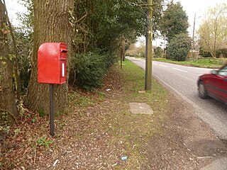
Horton Heath is a small village in Dorset, England situated one mile from Three Legged Cross and two miles from Horton. It consists of a main road, with Slough Lane and an unnamed road as the only two paved roads coming off it. There are several farms.

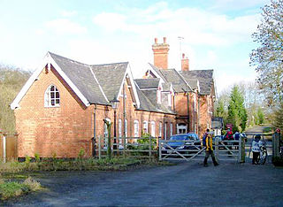
Mickleover railway station is a disused railway station serving the village of Mickleover, Derbyshire, England,. It was opened by the Great Northern Railway on its Derbyshire Extension in 1878.
Kałęczyn is a village in the administrative district of Gmina Piątnica, within Łomża County, Podlaskie Voivodeship, in north-eastern Poland.

Hendon War Memorial in Hendon, North London is located on the central reservation at the junction between Watford Way and The Burroughs. It was unveiled on St George's Day, 23 April 1922, but was moved to its present location in 1962.

Turza Wielka is a village in the administrative district of Gmina Lipowiec Kościelny, within Mława County, Masovian Voivodeship, in east-central Poland. It lies approximately 4 kilometres (2 mi) north-east of Lipowiec Kościelny, 9 km (6 mi) west of Mława, and 113 km (70 mi) north-west of Warsaw.
Przylądek is a settlement in the administrative district of Gmina Ostróda, within Ostróda County, Warmian-Masurian Voivodeship, in northern Poland.
Łowno is a settlement in the administrative district of Gmina Kalisz Pomorski, within Drawsko County, West Pomeranian Voivodeship, in north-western Poland.

The Tokyo Bunka Kaikan (東京文化会館) is a Japanese concert hall located in Ueno Park, Taitō, Tokyo. Designed by Japanese architect Kunio Maekawa, it was built in 1961 and renovated in 1998–99. Its larger hall seats 2303 people, and its small hall seats 649. It is operated by the Tokyo Metropolitan Foundation for History and Culture.
Bożydar-Kałęczyn was the name of a former jurydyka founded in 1702 near Warsaw. It was founded partly on the land of an existing village called Kałęczyn. The city hall was located at today's address, Nowy Swiat 8/10, by J. Szwarcenberg-Czerny.

Wolska is the main artery of Warsaw's borough of Wola. Initially Wola district was but a western suburb of Warsaw and a road leading to it was dubbed "droga wolska" - Wola road. In 1725 parts of that road closest to the Warsaw Old Town, located along the Saxon Axis, were officially renamed to "Aleja Wolska" - Wola Avenue. In modern times it starts at a crossing of Chłodna and Towarowa Streets, and runs as a continuation of Solidarity Avenue through the neighbourhoods of Młynów, Czyste and Ulrychów, all the way to Połczyńska Street.
Rijpdalen is a valley in the central part of Nordaustlandet, Svalbard, separating Gustav V Land from Prins Oscars Land. The valley extends between the head of Wahlenbergfjorden and the head of Rijpfjorden. The valley is named after Dutch explorer Jan Rijp. At the watershed in Rijpdalen is the plain of Helvetesflya. The ice caps of Vestfonna and Austfonna are separated by Rijpdalen and Helvetesflya.
Dranytsia is a commune (silrada) in Novoselytsia Raion, Chernivtsi Oblast, Ukraine. It is composed of two villages, Dranytsia and Negryntsi.

The Monplaisir Palace is part of the Peterhof Palace Complex, Russia.
Christiania Burgher School was a private middle school in Christiania, Norway. It was founded in 1812 and prepared pupils for enrollment at Oslo Cathedral School.


