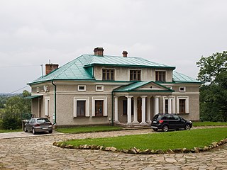
Blizne Ukrainian: Близне, Blyzne is a village in the administrative district of Gmina Jasienica Rosielna, within Brzozów County, Subcarpathian Voivodeship, in south-eastern Poland. It lies approximately 3 kilometres (2 mi) east of Jasienica Rosielna, 7 km (4 mi) north-west of Brzozów, and 32 km (20 mi) south of the regional capital Rzeszów. The village has a population of 2,800.
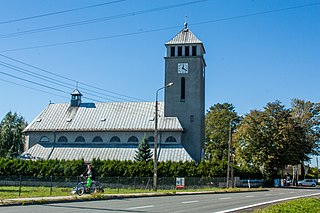
Zabełków is a village in the administrative district of Gmina Krzyżanowice, within Racibórz County, Silesian Voivodeship, in southern Poland, close to the Czech border. It lies approximately 9 kilometres (6 mi) south-east of Krzyżanowice, 19 km (12 mi) south-east of Racibórz, and 60 km (37 mi) south-west of the regional capital Katowice. It has a population of about 750.

Gmina Krzanowice, German Gemeinde Kranowitz is an urban-rural gmina in Racibórz County, Silesian Voivodeship, in southern Poland, on the Czech border. Its seat is the town of Krzanowice (Kranowitz), which lies approximately 11 kilometres (7 mi) south-west of Racibórz and 68 km (42 mi) west of the regional capital Katowice.
Gmina Lubomia is a rural gmina in Wodzisław County, Silesian Voivodeship, in southern Poland. Its seat is the village of Lubomia, which lies approximately 12 kilometres (7 mi) west of Wodzisław Śląski and 56 km (35 mi) south-west of the regional capital Katowice.

Białowieża is a village in the administrative district of Gmina Sędziszów, within Jędrzejów County, Świętokrzyskie Voivodeship, in south-central Poland. It lies approximately 8 kilometres (5 mi) south-west of Sędziszów, 25 km (16 mi) south-west of Jędrzejów, and 59 km (37 mi) south-west of the regional capital Kielce.
Bębnów is a village in the administrative district of Gmina Gowarczów, within Końskie County, Świętokrzyskie Voivodeship, in south-central Poland. It lies approximately 5 kilometres (3 mi) south-west of Gowarczów, 6 km (4 mi) north of Końskie, and 44 km (27 mi) north of the regional capital Kielce.
Popówek is a village in the administrative district of Gmina Gołuchów, within Pleszew County, Greater Poland Voivodeship, in west-central Poland. It lies approximately 5 kilometres (3 mi) south-east of Gołuchów, 15 km (9 mi) south-east of Pleszew, and 97 km (60 mi) south-east of the regional capital Poznań.
Lipczyno is a settlement in Gmina Miastko, Bytów County, Pomeranian Voivodeship, in northern Poland. It lies approximately 36 kilometres (22 mi) south-west of Bytów and 113 km (70 mi) south-west of Gdańsk.

Bieńkowice is a village in the administrative district of Gmina Krzyżanowice, within Racibórz County, Silesian Voivodeship, in southern Poland, close to the Czech border. It lies approximately 6 kilometres (4 mi) north-west of Krzyżanowice, 6 km (4 mi) south of Racibórz, and 61 km (38 mi) south-west of the regional capital Katowice.

Bolesław is a village in the administrative district of Gmina Krzyżanowice, within Racibórz County, Silesian Voivodeship, in southern Poland, close to the Czech border. It lies approximately 6 kilometres (4 mi) west of Krzyżanowice, 8 km (5 mi) south of Racibórz, and 63 km (39 mi) south-west of the regional capital Katowice.

Krzyżanowice is a village in Racibórz County, Silesian Voivodeship, in southern Poland, close to the Czech border. It is the seat of the gmina called Gmina Krzyżanowice. It lies approximately 10 kilometres (6 mi) south of Racibórz and 60 km (37 mi) south-west of the regional capital Katowice.

Owsiszcze is a village in the administrative district of Gmina Krzyżanowice, within Racibórz County, Silesian Voivodeship, in southern Poland, close to the Czech border. It lies approximately 4 kilometres (2 mi) south-west of Krzyżanowice, 12 km (7 mi) south of Racibórz, and 63 km (39 mi) south-west of the regional capital Katowice.
Roszków is a village in the administrative district of Gmina Krzyżanowice, within Racibórz County, Silesian Voivodeship, in southern Poland, close to the Czech border. It lies approximately 4 kilometres (2 mi) south-east of Krzyżanowice, 13 km (8 mi) south-east of Racibórz, and 59 km (37 mi) south-west of the regional capital Katowice.

Rudyszwałd is a village in the administrative district of Gmina Krzyżanowice, within Racibórz County, Silesian Voivodeship, in southern Poland, close to the Czech border. It lies approximately 6 kilometres (4 mi) south of Krzyżanowice, 16 km (10 mi) south of Racibórz, and 62 km (39 mi) south-west of the regional capital Katowice.

Tworków is a village in the administrative district of Gmina Krzyżanowice, within Racibórz County, Silesian Voivodeship, in southern Poland, close to the Czech border. It lies approximately 3 kilometres (2 mi) west of Krzyżanowice, 10 km (6 mi) south of Racibórz, and 62 km (39 mi) south-west of the regional capital Katowice.
Gródczanki is a village in the administrative district of Gmina Pietrowice Wielkie, within Racibórz County, Silesian Voivodeship, in southern Poland, close to the Czech border. It lies approximately 4 kilometres (2 mi) south-west of Pietrowice Wielkie, 14 km (9 mi) west of Racibórz, and 71 km (44 mi) west of the regional capital Katowice.
Pogorzała Wieś is a village in the administrative district of Gmina Miłoradz, within Malbork County, Pomeranian Voivodeship, in northern Poland. It lies approximately 5 kilometres (3 mi) south of Miłoradz, 10 km (6 mi) south-west of Malbork, and 48 km (30 mi) south-east of the regional capital Gdańsk.
Kuliki is a settlement in the administrative district of Gmina Sztum, within Sztum County, Pomeranian Voivodeship, in northern Poland. It lies approximately 5 kilometres (3 mi) south-west of Sztum and 57 km (35 mi) south-east of the regional capital Gdańsk.
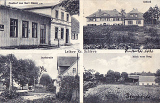
Lejkowo is a village in the administrative district of Gmina Malechowo, within Sławno County, West Pomeranian Voivodeship, in north-western Poland. It lies approximately 9 kilometres (6 mi) south-east of Malechowo, 15 km (9 mi) south-west of Sławno, and 161 km (100 mi) north-east of the regional capital Szczecin.


