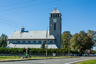
Zabełków is a village in the administrative district of Gmina Krzyżanowice, within Racibórz County, Silesian Voivodeship, in southern Poland, close to the Czech border. It lies approximately 9 kilometres (6 mi) south-east of Krzyżanowice, 19 km (12 mi) south-east of Racibórz, and 60 km (37 mi) south-west of the regional capital Katowice. It has a population of about 750.

Gmina Krzanowice, German Gemeinde Kranowitz is an urban-rural gmina in Racibórz County, Silesian Voivodeship, in southern Poland, on the Czech border. Its seat is the town of Krzanowice (Kranowitz), which lies approximately 11 kilometres (7 mi) south-west of Racibórz and 68 km (42 mi) west of the regional capital Katowice.

Wołowice is a village in the administrative district of Gmina Czernichów, within Kraków County, Lesser Poland Voivodeship, in southern Poland. It lies approximately 5 kilometres (3 mi) east of Czernichów and 18 km (11 mi) south-west of the regional capital Kraków.
Rudze is a village in the administrative district of Gmina Zator, within Oświęcim County, Lesser Poland Voivodeship, in southern Poland. It lies approximately 2 kilometres (1 mi) south-east of Zator, 18 km (11 mi) south-east of Oświęcim, and 36 km (22 mi) west of the regional capital Kraków.
Bodzanów is a village in the administrative district of Gmina Biskupice, within Wieliczka County, Lesser Poland Voivodeship, in southern Poland. It lies approximately 7 kilometres (4 mi) east of Wieliczka and 18 km (11 mi) south-east of the regional capital Kraków.
Łazy is a village in the administrative district of Gmina Radymno, within Jarosław County, Subcarpathian Voivodeship, in south-eastern Poland, close to the border with Ukraine. It lies approximately 6 kilometres (4 mi) north-east of Radymno, 14 km (9 mi) east of Jarosław, and 62 km (39 mi) east of the regional capital Rzeszów.
Lipnik is a village in the administrative district of Gmina Kańczuga, within Przeworsk County, Subcarpathian Voivodeship, in south-eastern Poland. It lies approximately 8 kilometres (5 mi) west of Kańczuga, 18 km (11 mi) south-west of Przeworsk, and 22 km (14 mi) east of the regional capital Rzeszów.
Redzyńskie is a village in the administrative district of Gmina Latowicz, within Mińsk County, Masovian Voivodeship, in east-central Poland. It lies approximately 5 kilometres (3 mi) south of Latowicz, 29 km (18 mi) south-east of Mińsk Mazowiecki, and 62 km (39 mi) south-east of Warsaw.
Janówek is a village in the administrative district of Gmina Tarczyn, within Piaseczno County, Masovian Voivodeship, in east-central Poland. It lies approximately 2 kilometres (1 mi) north-west of Tarczyn, 17 km (11 mi) south-west of Piaseczno, and 29 km (18 mi) south-west of Warsaw.
Dobrut is a village in the administrative district of Gmina Orońsko, within Szydłowiec County, Masovian Voivodeship, in east-central Poland. It lies approximately 2 kilometres (1 mi) south of Orońsko, 12 km (7 mi) north-east of Szydłowiec, and 102 km (63 mi) south of Warsaw.
Wydra is a village in the administrative district of Gmina Wręczyca Wielka, within Kłobuck County, Silesian Voivodeship, in southern Poland. It lies approximately 6 kilometres (4 mi) south-east of Wręczyca Wielka, 12 km (7 mi) south of Kłobuck, and 63 km (39 mi) north of the regional capital Katowice.

Borucin is a village in the administrative district of Gmina Krzanowice, within Racibórz County, Silesian Voivodeship, in southern Poland, close to the Czech border. It lies approximately 3 kilometres (2 mi) south-east of Krzanowice, 11 km (7 mi) south-west of Racibórz, and 67 km (42 mi) south-west of the regional capital Katowice.

Bieńkowice is a village in the administrative district of Gmina Krzyżanowice, within Racibórz County, Silesian Voivodeship, in southern Poland, close to the Czech border. It lies approximately 6 kilometres (4 mi) north-west of Krzyżanowice, 6 km (4 mi) south of Racibórz, and 61 km (38 mi) south-west of the regional capital Katowice.

Bolesław is a village in the administrative district of Gmina Krzyżanowice, within Racibórz County, Silesian Voivodeship, in southern Poland, close to the Czech border. It lies approximately 6 kilometres (4 mi) west of Krzyżanowice, 8 km (5 mi) south of Racibórz, and 63 km (39 mi) south-west of the regional capital Katowice.

Krzyżanowice is a village in Racibórz County, Silesian Voivodeship, in southern Poland, close to the Czech border. It is the seat of the gmina called Gmina Krzyżanowice. It lies approximately 10 kilometres (6 mi) south of Racibórz and 60 km (37 mi) south-west of the regional capital Katowice.
Nowa Wioska is a village in the administrative district of Gmina Krzyżanowice, within Racibórz County, Silesian Voivodeship, in southern Poland, close to the Czech border. It lies approximately 4 kilometres (2 mi) south-west of Krzyżanowice, 13 km (8 mi) south of Racibórz, and 62 km (39 mi) south-west of the regional capital Katowice.

Owsiszcze is a village in the administrative district of Gmina Krzyżanowice, within Racibórz County, Silesian Voivodeship, in southern Poland, close to the Czech border. It lies approximately 4 kilometres (2 mi) south-west of Krzyżanowice, 12 km (7 mi) south of Racibórz, and 63 km (39 mi) south-west of the regional capital Katowice.

Rudyszwałd is a village in the administrative district of Gmina Krzyżanowice, within Racibórz County, Silesian Voivodeship, in southern Poland, close to the Czech border. It lies approximately 6 kilometres (4 mi) south of Krzyżanowice, 16 km (10 mi) south of Racibórz, and 62 km (39 mi) south-west of the regional capital Katowice.

Tworków is a village in the administrative district of Gmina Krzyżanowice, within Racibórz County, Silesian Voivodeship, in southern Poland, close to the Czech border. It lies approximately 3 kilometres (2 mi) west of Krzyżanowice, 10 km (6 mi) south of Racibórz, and 62 km (39 mi) south-west of the regional capital Katowice.


