Turzyn is a village in the administrative district of Gmina Kcynia, within Nakło County, Kuyavian-Pomeranian Voivodeship, in north-central Poland. It lies approximately 6 kilometres (4 mi) east of Kcynia, 18 km (11 mi) south of Nakło nad Notecią, and 33 km (21 mi) south-west of Bydgoszcz.
Kowalewo is a village in the administrative district of Gmina Szubin, within Nakło County, Kuyavian-Pomeranian Voivodeship, in north-central Poland. It lies approximately 6 kilometres (4 mi) south of Szubin, 22 km (14 mi) south-east of Nakło nad Notecią, and 25 km (16 mi) south-west of Bydgoszcz.

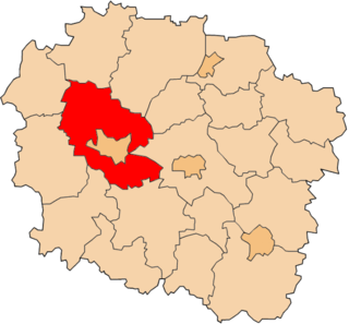
Królikowo is a village in the administrative district of Gmina Szubin, within Nakło County, Kuyavian-Pomeranian Voivodeship, in north-central Poland. It lies approximately 11 kilometres (7 mi) south-west of Szubin, 20 km (12 mi) south of Nakło nad Notecią, and 31 km (19 mi) south-west of Bydgoszcz.
Smolniki is a village in the administrative district of Gmina Szubin, within Nakło County, Kuyavian-Pomeranian Voivodeship, in north-central Poland. It lies approximately 4 kilometres (2 mi) south of Szubin, 21 km (13 mi) south-east of Nakło nad Notecią, and 22 km (14 mi) south-west of Bydgoszcz.
Zalesie is a village in the administrative district of Gmina Szubin, within Nakło County, Kuyavian-Pomeranian Voivodeship, in north-central Poland. It lies approximately 11 kilometres (7 mi) west of Szubin, 18 km (11 mi) south of Nakło nad Notecią, and 31 km (19 mi) south-west of Bydgoszcz.
Mielinek is a village in the administrative district of Gmina Chodecz, within Włocławek County, Kuyavian-Pomeranian Voivodeship, in north-central Poland. It lies approximately 4 kilometres (2 mi) north-west of Chodecz, 27 km (17 mi) south of Włocławek, and 73 km (45 mi) south of Toruń.
Bystrzyca is a village in the administrative district of Gmina Mogilno, within Mogilno County, Kuyavian-Pomeranian Voivodeship, in north-central Poland. It lies approximately 3 kilometres (2 mi) south-east of Mogilno and 54 km (34 mi) south of Bydgoszcz.
Danówka is a village in the administrative district of Gmina Drelów, within Biała Podlaska County, Lublin Voivodeship, in eastern Poland. It lies approximately 9 kilometres (6 mi) north-east of Drelów, 12 km (7 mi) south-west of Biała Podlaska, and 85 km (53 mi) north of the regional capital Lublin.
Nowodworze is a village in the administrative district of Gmina Tarnów, within Tarnów County, Lesser Poland Voivodeship, in southern Poland. It lies approximately 8 kilometres (5 mi) south of Tarnów and 76 km (47 mi) east of the regional capital Kraków.
Budy Sułkowskie is a village in the administrative district of Gmina Strzegowo, within Mława County, Masovian Voivodeship, in east-central Poland. It lies approximately 11 kilometres (7 mi) north-east of Strzegowo, 17 km (11 mi) south of Mława, and 93 km (58 mi) north-west of Warsaw.
Dąbrowa is a village in the administrative district of Gmina Strzegowo, within Mława County, Masovian Voivodeship, in east-central Poland. It lies approximately 8 kilometres (5 mi) north of Strzegowo, 18 km (11 mi) south of Mława, and 97 km (60 mi) north-west of Warsaw.
Ignacewo is a village in the administrative district of Gmina Strzegowo, within Mława County, Masovian Voivodeship, in east-central Poland. It lies approximately 9 kilometres (6 mi) north-east of Strzegowo, 17 km (11 mi) south of Mława, and 95 km (59 mi) north-west of Warsaw.
Parówki is a village in the administrative district of Gmina Strzegowo, within Mława County, Masovian Voivodeship, in east-central Poland. It lies approximately 10 kilometres (6 mi) north of Strzegowo, 17 km (11 mi) south-west of Mława, and 99 km (62 mi) north-west of Warsaw.
Bobrowiec is a village in the administrative district of Gmina Piaseczno, within Piaseczno County, Masovian Voivodeship, in east-central Poland. It lies approximately 4 kilometres (2 mi) west of Piaseczno and 17 km (11 mi) south of Warsaw.
Świerczynek is a village in the administrative district of Gmina Drobin, within Płock County, Masovian Voivodeship, in east-central Poland. It lies approximately 2 kilometres (1 mi) south-west of Drobin, 28 km (17 mi) north-east of Płock, and 91 km (57 mi) north-west of Warsaw.
Białocin is a village in the administrative district of Gmina Iłów, within Sochaczew County, Masovian Voivodeship, in east-central Poland. It lies approximately 8 kilometres (5 mi) south-west of Iłów, 20 km (12 mi) west of Sochaczew, and 71 km (44 mi) west of Warsaw.
Lipnica is a village in the administrative district of Gmina Ostrowite, within Słupca County, Greater Poland Voivodeship, in west-central Poland. It lies approximately 7 kilometres (4 mi) north-west of Ostrowite, 15 km (9 mi) north-east of Słupca, and 72 km (45 mi) east of the regional capital Poznań.
Grabowo is a village in the administrative district of Gmina Gołańcz, within Wągrowiec County, Greater Poland Voivodeship, in west-central Poland. It lies approximately 5 kilometres (3 mi) north-west of Gołańcz, 19 km (12 mi) north of Wągrowiec, and 67 km (42 mi) north of the regional capital Poznań.
Konary is a village in the administrative district of Gmina Gołańcz, within Wągrowiec County, Greater Poland Voivodeship, in west-central Poland. It lies approximately 5 kilometres (3 mi) north-west of Gołańcz, 19 km (12 mi) north of Wągrowiec, and 67 km (42 mi) north of the regional capital Poznań.
Zawiść is a village in the administrative district of Gmina Pokój, within Namysłów County, Opole Voivodeship, in south-western Poland. It lies approximately 12 kilometres (7 mi) north-east of Pokój, 21 km (13 mi) south-east of Namysłów, and 36 km (22 mi) north of the regional capital Opole.