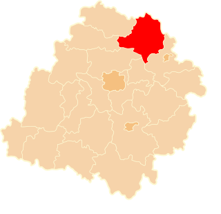
Krzywa is a village in the administrative district of Gmina Chojnów, within Legnica County, Lower Silesian Voivodeship, in south-western Poland. Prior to 1945 it was in Germany. It lies approximately 9 kilometres (6 mi) west of Chojnów, 26 km (16 mi) west of Legnica, and 88 km (55 mi) west of the regional capital Wrocław.
Szczedrzykowice-Stacja is a village in the administrative district of Gmina Prochowice, within Legnica County, Lower Silesian Voivodeship, in south-western Poland. Prior to 1945 it was in Germany.

Lniano is a village in Świecie County, Kuyavian-Pomeranian Voivodeship, in north-central Poland. It is the seat of the gmina called Gmina Lniano. It lies approximately 20 kilometres (12 mi) north-west of Świecie and 48 km (30 mi) north of Bydgoszcz.

Rokitów is a village in the administrative district of Gmina Turobin, within Biłgoraj County, Lublin Voivodeship, in eastern Poland. It lies approximately 2 kilometres (1 mi) south-east of Turobin, 30 km (19 mi) north of Biłgoraj, and 51 km (32 mi) south of the regional capital Lublin.
Rubcowo is a village in the administrative district of Gmina Płaska, within Augustów County, Podlaskie Voivodeship, in north-eastern Poland, close to the border with Belarus. It lies approximately 17 kilometres (11 mi) south-east of Płaska, 32 km (20 mi) east of Augustów, and 80 km (50 mi) north of the regional capital Białystok.
Łazy Małe is a village in the administrative district of Gmina Tykocin, within Białystok County, Podlaskie Voivodeship, in north-eastern Poland.
Eligiów is a village in the administrative district of Gmina Sulmierzyce, within Pajęczno County, Łódź Voivodeship, in central Poland.
Kaliszany-Kolonia is a village in the administrative district of Gmina Józefów nad Wisłą, within Opole Lubelskie County, Lublin Voivodeship, in eastern Poland.
Bedlno is a village in the administrative district of Gmina Radzyń Podlaski, within Radzyń Podlaski County, Lublin Voivodeship, in eastern Poland. The village is the seat of the administrative district (gmina) known as Gmina Bedlno. It has a population of approximately 640.
Raszówek is a village in the administrative district of Gmina Słaboszów, within Miechów County, Lesser Poland Voivodeship, in southern Poland. It lies approximately 6 kilometres (4 mi) south-west of Słaboszów, 13 km (8 mi) east of Miechów, and 39 km (24 mi) north-east of the regional capital Kraków.
Podłukawka is a village in the administrative district of Gmina Wojciechowice, within Opatów County, Świętokrzyskie Voivodeship, in south-central Poland. It lies approximately 4 kilometres (2 mi) south of Wojciechowice, 11 km (7 mi) east of Opatów, and 68 km (42 mi) east of the regional capital Kielce.
Sielce is a village in the administrative district of Gmina Stromiec, within Białobrzegi County, Masovian Voivodeship, in east-central Poland.
Aleksandrów is a village in the administrative district of Gmina Jakubów, within Mińsk County, Masovian Voivodeship, in east-central Poland. It lies approximately 5 kilometres (3 mi) east of Jakubów, 13 km (8 mi) east of Mińsk Mazowiecki, and 51 km (32 mi) east of Warsaw.
Kokanin is a village in the administrative district of Gmina Żelazków, within Kalisz County, Greater Poland Voivodeship, in west-central Poland. It lies approximately 7 kilometres (4 mi) north of Kalisz and 104 km (65 mi) south-east of the regional capital Poznań.
Mszaniec is a village in the administrative district of Gmina Kłodawa, within Gorzów County, Lubusz Voivodeship, in western Poland.
Wilczy Dół is a settlement in the administrative district of Gmina Dobiegniew, within Strzelce-Drezdenko County, Lubusz Voivodeship, in western Poland. It lies approximately 7 kilometres (4 mi) south-east of Dobiegniew, 20 km (12 mi) east of Strzelce Krajeńskie, and 44 km (27 mi) north-east of Gorzów Wielkopolski.
Dębczyn is a settlement in the administrative district of Gmina Sława, within Wschowa County, Lubusz Voivodeship, in western Poland.
Giełdon is a village in the administrative district of Gmina Brusy, within Chojnice County, Pomeranian Voivodeship, in northern Poland. It lies approximately 9 kilometres (6 mi) south of Brusy, 17 km (11 mi) north-east of Chojnice, and 86 km (53 mi) south-west of the regional capital Gdańsk.
Powalina is a village in the administrative district of Gmina Nowy Dwór Gdański, within Nowy Dwór Gdański County, Pomeranian Voivodeship, in northern Poland. It lies approximately 6 kilometres (4 mi) east of Nowy Dwór Gdański and 41 km (25 mi) south-east of the regional capital Gdańsk.
Niemierzyno is a settlement in the administrative district of Gmina Połczyn-Zdrój, within Świdwin County, West Pomeranian Voivodeship, in north-western Poland.