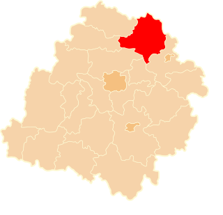
Zawada is a village in the administrative district of Gmina Pruszcz, within Świecie County, Kuyavian-Pomeranian Voivodeship, in north-central Poland. It lies approximately 5 kilometres (3 mi) south of Pruszcz, 22 km (14 mi) south-west of Świecie, and 23 km (14 mi) north-east of Bydgoszcz.
Chmielnik is a village in the administrative district of Gmina Czarna Białostocka, within Białystok County, Podlaskie Voivodeship, in north-eastern Poland. It lies approximately 8 kilometres (5 mi) north-west of Czarna Białostocka and 24 km (15 mi) north of the regional capital Białystok.
Żylicze is a village in the administrative district of Gmina Krynki, within Sokółka County, Podlaskie Voivodeship, in north-eastern Poland, close to the border with Belarus. It lies approximately 9 kilometres (6 mi) south of Krynki, 30 km (19 mi) south-east of Sokółka, and 41 km (25 mi) east of the regional capital Białystok.
Niedzieliska is a village in the administrative district of Gmina Kiernozia, within Łowicz County, Łódź Voivodeship, in central Poland.
Nowy Złaków is a village in the administrative district of Gmina Zduny, within Łowicz County, Łódź Voivodeship, in central Poland.
Turzystwo is a village in the administrative district of Gmina Adamów, within Łuków County, Lublin Voivodeship, in eastern Poland. It lies approximately 7 kilometres (4 mi) south-west of Adamów, 28 km (17 mi) south-west of Łuków, and 58 km (36 mi) north-west of the regional capital Lublin.
Ludwinów is a village in the administrative district of Gmina Małogoszcz, within Jędrzejów County, Świętokrzyskie Voivodeship, in south-central Poland. It lies approximately 6 kilometres (4 mi) west of Małogoszcz, 23 km (14 mi) north of Jędrzejów, and 31 km (19 mi) west of the regional capital Kielce.

Przysłup is a village in the administrative district of Gmina Cisna, within Lesko County, Subcarpathian Voivodeship, in south-eastern Poland, close to the border with Slovakia. It lies approximately 5 kilometres (3 mi) south-east of Cisna, 33 km (21 mi) south of Lesko, and 98 km (61 mi) south of the regional capital Rzeszów.

Mnin is a village in the administrative district of Gmina Słupia Konecka, within Końskie County, Świętokrzyskie Voivodeship, in south-central Poland. It lies approximately 5 kilometres (3 mi) south-east of Słupia, 29 km (18 mi) south-west of Końskie, and 33 km (21 mi) west of the regional capital Kielce.
Wodziczna is a village in the administrative district of Gmina Mogielnica, within Grójec County, Masovian Voivodeship, in east-central Poland. It lies approximately 4 kilometres (2 mi) north of Mogielnica, 19 km (12 mi) south-west of Grójec, and 58 km (36 mi) south of Warsaw.
Ignaców is a village in the administrative district of Gmina Mińsk Mazowiecki, within Mińsk County, Masovian Voivodeship, in east-central Poland.
Marianka is a village in the administrative district of Gmina Brody, within Żary County, Lubusz Voivodeship, in western Poland, close to the German border. It lies approximately 5 kilometres (3 mi) south-west of Brody, 32 km (20 mi) north-west of Żary, and 57 km (35 mi) west of Zielona Góra.
Suchodół is a village in the administrative district of Gmina Brody, within Żary County, Lubusz Voivodeship, in western Poland, close to the German border. It lies approximately 3 kilometres (2 mi) west of Brody, 34 km (21 mi) north-west of Żary, and 56 km (35 mi) west of Zielona Góra.
Piekło Dolne is a village in the administrative district of Gmina Przywidz, within Gdańsk County, Pomeranian Voivodeship, in northern Poland. It lies approximately 2 kilometres (1 mi) south-west of Przywidz, 23 km (14 mi) south-west of Pruszcz Gdański, and 29 km (18 mi) south-west of the regional capital Gdańsk.
Stary Młyn is a settlement in the administrative district of Gmina Prabuty, within Kwidzyn County, Pomeranian Voivodeship, in northern Poland. It lies approximately 3 kilometres (2 mi) south of Prabuty, 17 km (11 mi) east of Kwidzyn, and 79 km (49 mi) south-east of the regional capital Gdańsk.
Łętowo is a settlement in the administrative district of Gmina Piecki, within Mrągowo County, Warmian-Masurian Voivodeship, in northern Poland.
Jaroty is a settlement in the administrative district of Gmina Stawiguda, within Olsztyn County, Warmian-Masurian Voivodeship, in northern Poland. It lies approximately 10 kilometres (6 mi) north-east of Stawiguda and 6 km (4 mi) south of the regional capital Olsztyn.
Kęty is a village in the administrative district of Gmina Małdyty, within Ostróda County, Warmian-Masurian Voivodeship, in northern Poland. It lies approximately 9 kilometres (6 mi) south of Małdyty, 23 km (14 mi) north-west of Ostróda, and 51 km (32 mi) west of the regional capital Olsztyn.
Zakłodzie is a village in the administrative district of Gmina Nowogard, within Goleniów County, West Pomeranian Voivodeship, in north-western Poland. It lies approximately 10 kilometres (6 mi) north-west of Nowogard, 25 km (16 mi) north-east of Goleniów, and 46 km (29 mi) north-east of the regional capital Szczecin.
Nowe Borne is a settlement in the administrative district of Gmina Połczyn-Zdrój, within Świdwin County, West Pomeranian Voivodeship, in north-western Poland.