Nu'ulopa

Last updated

Nu'ulopa is a small uninhabited island in the Apolima Strait between the islands of Upolu and Savai'i in Samoa. The island is part of Aiga-i-le-Tai district.

Apolima Strait strait

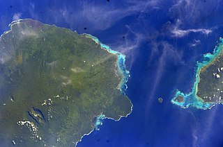
The Apolima Strait is about 13 km wide and separates the two largest islands of Samoa, the island of Savai'i to the northwest, and Upolu to the southeast.

Upolu island in Samoa

Upolu is an island in Samoa, formed by a massive basaltic shield volcano which rises from the seafloor of the western Pacific Ocean. The island is 75 kilometres long and 1,125 square kilometres in area, making it the second largest of the Samoan Islands geographically. With approximately 145,000 people, it is by far the most populated of the Samoan Islands. Upolu is situated to the southeast of Savai'i, the "big island". Apia, the capital, is in the middle of the north coast, with Faleolo International Airport at the western end of the island. The island has not had any historically recorded eruptions, although three lava flows date back only a few hundred to a few thousand years.

Savaii Island in the Samoan Islands chain

Savaiʻi is the largest and highest island in Samoa and the Samoan Islands chain. The island is the fifth largest in Polynesia, behind the two main islands of New Zealand and the Hawaiian Islands of Hawaii and Maui.

Contents

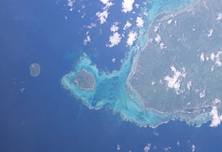
Nu'ulopa is about 50m high. It is also a small forested rocky outcrop with coconut palms (Cocos nucifera) and a conservation area for flying foxes. The surrounding sea is a conservation area for turtles. [1]

<i>Pteropus</i> Genus of large bats

Pteropus is a genus of bats which are among the largest in the world. They are commonly known as fruit bats or flying foxes, among other colloquial names. They live in the tropics and subtropics of Asia, Australia, East Africa, and some oceanic islands in the Indian and Pacific Oceans. There are at least 60 extant species in the genus.

Nu'ulopa sits between another two islands Apolima and Manono. The islands lie on an underwater ridge connecting the two main islands of Upolu and Savai'i.

Manono Island island

Manono is an island of Samoa, situated in the Apolima Strait between the main islands of Savai'i and Upolu, 3.4 km WNW off Lefatu Cape, the westernmost point of Upolu.

Nu'ulopa is generally used as a cemetery for the high chiefs (matai) of Manono.

Faamatai Chiefly system of Samoa

Fa'amatai is the chiefly system of Samoa, central to the organization of Samoan society. It is the traditional indigenous form of governance in the Samoa Islands, comprising American Samoa and the Independent State of Samoa. The term comprises the prefix fa'a and the word matai.

Heading towards Nu'ulopa island in a boat. Apolima Tai village on Apolima island is to the right and Savai'i island in the distance. Nu'ulopa island - Samoa.jpg
Heading towards Nu'ulopa island in a boat. Apolima Tai village on Apolima island is to the right and Savai'i island in the distance.
Nearing the island by boat. Nu'ulopa island picnic site - Samoa.jpg
Nearing the island by boat.
Visitor on a beach on the island. Nu'ulopa island beach - Samoa.jpg
Visitor on a beach on the island.

See also

Related Research Articles

Geography of Samoa geography of the Independent State of Samoa (and not American Samoa)

The country of Samoa consists of the two large islands of Upolu and Savai'i and eight smaller islands located about halfway between Hawaii and New Zealand in the Polynesian region of the South Pacific Ocean. The island of Upolu is home to nearly three-quarters of Samoa's population and its capital city of Apia. Samoa occupies an almost central position within Polynesia. The climate is tropical, with a rainy season from November to April. To the east is the smaller American Samoa.

Samoan Islands archipelago covering 3,030 km² (1,170 sq mi) in the central South Pacific, forming part of Polynesia and the wider region of Oceania

The Samoan Islands are an archipelago covering 3,030 km2 (1,170 sq mi) in the central South Pacific, forming part of Polynesia and the wider region of Oceania. Administratively, the archipelago comprises all of Samoa and most of American Samoa. The two Samoan jurisdictions are separated by 64 km (40 mi) of ocean.

Mulifanua Village District in Aiga-i-le-Tai, Samoa

Mulifanua is a village on the north-western tip of the island of Upolu, in Samoa. In the modern era, it is the capital of Aiga-i-le-Tai district. Mulifanua wharf is the main ferry terminal for inter-island vehicle and passenger travel across the Apolima Strait between Upolu and the island of Savai'i.

Salelologa Township & Ferry Terminal in Faasaleleaga, Samoa

Salelologa is a village district at the east end of Savai'i island in Samoa. It is the main entry point into the island with the only ferry terminal on Savai'i. It also serves as the main township for shopping and public amenities with a market selling fresh produce and arts and crafts.

Districts of Samoa

Samoa is made up of eleven itūmālō. These are the traditional eleven districts that were established well before European arrival. Each district has its own constitutional foundation (faavae) based on the traditional order of title precedence found in each district's faalupega.

Aiga-i-le-Tai District in Samoa

Aiga-i-le-Tai is a district of Samoa which includes the small islands of Manono, Apolima and tiny uninhabited Nu'ulopa lying in the Apolima Strait between the country's two main islands of Upolu and Savai'i.

Gagaemauga District in Samoa

Gaga'emauga is a district on the island of Savai'i in Samoa. The district is situated on the central north side of Savai'i. The name Gaga'emauga literally means "near side of the mountain", meaning the eastern side of the mountain chain running through the centre of Savai'i Island.

Tuamasaga District in Samoa

Tuamasaga is a district of Samoa, with a population of 83,191. The geographic area of Tuamasaga covers the central part of Upolu island.

Faasaleleaga District in Samoa

Fa'asaleleaga is a district of Samoa situated on the eastern side of Savai'i island. It has a population of 12,949.

Apai is one of four small villages on Manono Island in Samoa. The village population is 111.

Faleu is one of four small historic villages on Manono Island in Samoa. The village population is 354.

Salua is one of four small villages on Manono Island in Samoa. The village population is 201.

Apolima Tai

Apolima Tai is a small village settlement on the tiny volcanic island of Apolima in Samoa. The village is situated on the north side of the islet which is in the political district of Aiga-i-le-Tai.

Lepuia'i is one of four small villages on Manono Island in Samoa. The village population is 223.

References

Coordinates: 13°50′33″S172°07′45″W / 13.8424°S 172.1293°W / -13.8424; -172.1293

Geographic coordinate system Coordinate system

A geographic coordinate system is a coordinate system that enables every location on Earth to be specified by a set of numbers, letters or symbols. The coordinates are often chosen such that one of the numbers represents a vertical position and two or three of the numbers represent a horizontal position; alternatively, a geographic position may be expressed in a combined three-dimensional Cartesian vector. A common choice of coordinates is latitude, longitude and elevation. To specify a location on a plane requires a map projection.