Nunatak Glacier

Last updated
Nunatak Glacier
Nunatakgletscher
Aerial photographs of Greenland ENBLA04.jpg
View of the Nunatak Glacier terminus at the head of Geologfjord
Greenland edcp relief location map.jpg
Blue pog.svg
Location within Greenland
Type Piedmont glacier
Location Greenland
Coordinates 73°57′N26°0′W / 73.950°N 26.000°W / 73.950; -26.000 Coordinates: 73°57′N26°0′W / 73.950°N 26.000°W / 73.950; -26.000
Length20 km (12 mi)
Width2.5 km (1.6 mi)
Terminus Geologfjord
Kaiser Franz Joseph Fjord
Greenland Sea

Nunatak Glacier (Danish : Nunatakgletscher), also known as Nunatak Glacier, [1] is a glacier in King Christian X Land, Northeast Greenland. Administratively it lies in the Northeast Greenland National Park zone.

Danish language

Danish is a North Germanic language spoken by around six million people, principally in Denmark and in the region of Southern Schleswig in northern Germany, where it has minority language status. Also, minor Danish-speaking communities are found in Norway, Sweden, Spain, the United States, Canada, Brazil, and Argentina. Due to immigration and language shift in urban areas, around 15–20% of the population of Greenland speak Danish as their first language.

Glacier Persistent body of ice that is moving under its own weight

A glacier is a persistent body of dense ice that is constantly moving under its own weight; it forms where the accumulation of snow exceeds its ablation over many years, often centuries. Glaciers slowly deform and flow due to stresses induced by their weight, creating crevasses, seracs, and other distinguishing features. They also abrade rock and debris from their substrate to create landforms such as cirques and moraines. Glaciers form only on land and are distinct from the much thinner sea ice and lake ice that form on the surface of bodies of water.

King Christian X Land Region in Greenland

King Christian X Land is an area of northeastern Greenland.

Contents

The area where the glacier flows is remote and uninhabited.

History

This glacier was named Nunatak glacieren in 1899 by Swedish Arctic explorer and geologist A.G. Nathorst during the expedition he led to Greenland in search of survivors of S. A. Andrée's Arctic balloon expedition of 1897. The name was chosen owing to the tops of nunataks appearing to overhang it. [1]

Geologist Scientist who studies geology

A geologist is a scientist who studies the solid, liquid, and gaseous matter that constitutes the Earth and other terrestrial planets, as well as the processes that shape them. Geologists usually study geology, although backgrounds in physics, chemistry, biology, and other sciences are also useful. Field work is an important component of geology, although many subdisciplines incorporate laboratory work.

Alfred Gabriel Nathorst Swedish explorer and geologist

Dr Alfred Gabriel Nathorst HFRSE FLS FGS was a Swedish Arctic explorer, geologist and palaeobotanist.

Nunatak Exposed, often rocky element of a ridge, mountain, or peak not covered with ice or snow within an ice field or glacier

A nunatak is an exposed, often rocky element of a ridge, mountain, or peak not covered with ice or snow within an ice field or glacier. They are also called glacial islands. Examples are natural pyramidal peaks. When rounded by glacial action, smaller rock promontories may be referred to as rognons.

Geography

The Nunatak Glacier originates at the eastern end of the Adolf Hoel Glacier, south of the area of the Jakob Kjøde Bjerg nunatak. Strindberg Land lies to the east and the northeastern end of Andrée Land on its western side. It flows in a roughly northwest to southeast direction for about 20 km (12 mi) until its terminus at the head of the Geologfjord. [2] The Eyvind Fjeld Glacier flows beyond the northwestern end of the Nunatak Glacier, to the west of Jakob Kjøde Bjerg. [3]

Adolf Hoel Glacier glacier in Greenland

Adolf Hoel Glacier, also known as Hoel Glacier(Hoels Gletscher), is one of the major glaciers in King Christian X Land, Northeast Greenland. Administratively it lies in the Northeast Greenland National Park zone.

Andrée Land (Greenland) peninsula in Greenland

Andrée Land is a peninsula in King Christian X Land, East Greenland that is bounded by Kejser Franz Joseph Fjord, Isfjord and Geologfjord.

Geologfjord fjord in Greenland

Geologfjord is a fjord in King Christian X Land, East Greenland. Administratively it belongs to the Northeast Greenland National Park.

Map of Northeastern Greenland Operational Navigation Chart B-9, 1st edition.jpg
Map of Northeastern Greenland

Bibliography

See also

Related Research Articles

Lyell Land peninsula in Greenland

Lyell Land is a peninsula in King Christian X Land, East Greenland. It is located in the King Oscar Fjord area. Administratively it is part of the Northeast Greenland National Park zone.

Kaiser Franz Joseph Fjord fjord in Greenland

Kaiser Franz Joseph Fjord is a major fjord system in the NE Greenland National Park area, East Greenland.

Frænkel Land peninsula in Greenland

Frænkel Land is a peninsula in King Christian X Land, East Greenland. Administratively it is part of the Northeast Greenland National Park.

Jokel Bay bay in Greenland

Jokel Bay is a large bay in North Eastern Greenland. The area of the bay is uninhabited. Administratively Jokel Bay and its surroundings belong to the Northeast Greenland National Park.

Waltershausen Glacier

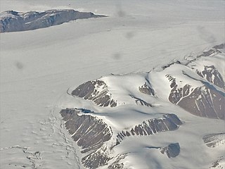
Waltershausen Glacier is one of the major glaciers in Greenland. It has its terminus on the east coast of the Greenland ice sheet.

Petermann Peak mountain in Northeast Greenland National Park Greenland

Petermann Peak,, also known as Petermann Fjeld, Petermanns Topp and Petermann Point is a mountain in King Christian X Land, Northeast Greenland. Administratively it is part of the Northeast Greenland National Park zone.

Schweizerland

Schweizerland, also known as Schweizerland Alps, is a mountain range in King Christian IX Land, eastern Greenland. Administratively this range is part of the Sermersooq Municipality. Its highest point is one of the highest peaks in Greenland.

Queen Louise Land

Queen Louise Land is a vast mountainous region located west of Dove Bay, King Frederick VIII Land, northeastern Greenland. Administratively it is part of the Northeast Greenland National Park zone.

Lindbergh Range

The Lindbergh Range or Lindbergh Nunataks is a mountain range in King Christian IX Land, eastern Greenland. Administratively the range is part of the Sermersooq Municipality.

Farquhar Glacier

Farquhar Glacier, is a glacier in northwestern Greenland. Administratively it belongs to the Avannaata municipality.

Roosevelt Range mountain range in Greenland

The Roosevelt Range or Roosevelt Mountains is a mountain range in Northern Greenland. Administratively this range is part of the Northeast Greenland National Park. Its highest peak is the highest point in Peary Land.

Th. Sørensen Land Region in Northeast Greenland National Park, Greenland

Th. Sørensen Land is an area in King Christian X Land, Eastern Greenland, part of the inner Scoresby Sound system. Administratively it lies in the Northeast Greenland National Park zone. The area is remote and uninhabited.

Nathorst Land (Greenland) Region in Northeast Greenland National Park, Greenland

Nathorst Land is an area in King Christian X Land, Eastern Greenland. It lies in the Northeast Greenland National Park zone. The area is remote and uninhabited.

Suess Land peninsula in Greenland

Suess Land is a peninsula in King Christian X Land, East Greenland. Administratively it is part of the Northeast Greenland National Park.

Louise Boyd Land Region in Northeast Greenland National Park, Greenland

Louise Boyd Land is an area in King Christian X Land, Eastern Greenland. Administratively it lies in the Northeast Greenland National Park zone. The area is remote and uninhabited.

Hamberg Glacier (Greenland)

Hamberg Glacier is one of the major glaciers in King Christian X Land, Northeast Greenland. Administratively it lies in the Northeast Greenland National Park zone.

References

  1. 1 2 "Catalogue of place names in northern East Greenland". Geological Survey of Denmark. Retrieved 2 August 2019.
  2. "Nunatakgletscher". Mapcarta. Retrieved 2 August 2019.
  3. journey across the nunataks of central east greenland, 1951