
Masaka District is a district in Buganda Kingdom in Uganda. Its main town is Masaka City, whose estimated population in 2011 was 74,100.

Rakai District is a district in the Central Region of Uganda. The town of Rakai is the site of the district's headquarters.

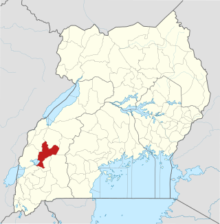
Sembabule District is a district in the Central Region of Uganda. The town of Sembabule is the site of the district headquarters. Other urban centers in the district include Lwemiyaga and Ntuusi.
Kamwenge District is a district in Western Uganda. It is named after its 'chief town', Kamwenge, where the district headquarters are located. Kamwenge District is part of the Kingdom of Toro, one of the ancient traditional monarchies in Uganda. The kingdom is coterminous with Toro sub-region. The districts that constitute the sub-region are: (a) Bunyangabu District (b) Kabarole District (c) Kamwenge District (d) Kyegegwa District (e) Kitagwenda District and (f) Kyenjojo District.

Uganda Martyrs University (UMU) is a private University affiliated with the Roman Catholic Church in Uganda. The University is owned by the Episcopal Conference of the Catholic Bishops of Uganda. It is licensed by the Uganda National Council for Higher Education. UMU consists of seven Faculties, two Institute, six Campuses, nine Departments, and three schools. As of March 2022, total student enrollment is 4,632. Of these, about 1,500 students were residential, while nearly 3,000 students were enrolled in UMU's distance learning programs. The number of staff members was over 400.

Kiruhura District is a district in the Western Region of Uganda. The town of Rushere is the site of the district headquarters.
Kiruhura is a town in the Western Region of Uganda. It is the largest town in Kiruhura District and the site of the district headquarters.

Lyantonde District is a district in southern Central Uganda. It is named after the 'chief town' of the district, Lyantonde, where the district headquarters are located.
Lyantonde is a town in the southern part of the Central Region of Uganda. It is the main municipal, administrative, and commercial center of Lyantonde District.
Rushere is a town in Kiruhura District in the Western Region of Uganda.

Buhweju District is a district in Western Uganda. It is one of the districts that constitute the Ankole sub-region. Its 'chief town', is Nsiika.
Sanga, is an urban center in the Kiruhura District, Ankole sub-region, in the Western Region of Uganda.
The Nyakahita–Kazo–Kamwenge–Fort Portal Road is a road in the Western Region of Uganda, connecting the towns of Nyakahita and Kazo in Kiruhura District, Ibanda in Ibanda District, Kamwenge in Kamwenge District, and Fort Portal in Kabarole District.
Kazo is a town in the Western Region of Uganda. It is the capital of Kazo District.
The Masaka–Mbarara Road is a road in the Central and Western Regions of Uganda, connecting the cities of Masaka in Masaka District, Central Region and Mbarara in Mbarara District, Western Region.
Amos Dairies Uganda Limited, also Amos Dairies, is a dairy processing company in Uganda. It is a subsidiary of Amos Dairies Limited, an Indian company with headquarters in New Delhi, India.
Mbarara–Ishaka Road is a road in the Western Region of Uganda, connecting the towns of Mbarara in Mbarara District with Ishaka in Bushenyi District.
Lyantonde General Hospital, also Lyantonde District Hospital or Lyantonde Government Hospital, is a hospital in the Central Region of Uganda.
Bihanga is a settlement in Ibanda District in the Western Region of Uganda. It is the location of the headquarters of Bihanga Parish, Nyamarebe sub-county.
Kazo is a district in Uganda's Western Region. It is located approximately 200 square kilometres (77 sq mi) west of Uganda's capital Kampala. It covers an area of 1,556 square kilometres (601 sq mi) and recorded a population of 177,054 in the 2014 Ugandan census. The capital of the district is the town of Kazo.
