
Sadasivpet is a town in sangareddy district of the Indian state of Telangana.

Seethanagaram is a mandal in Vizianagaram district of the Indian state of Andhra Pradesh.

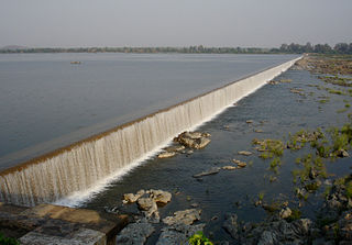
Hiramandalam is a census town in Srikakulam district of the Indian state of Andhra Pradesh. It is also the mandal headquarters of Hiramandalam mandal in Palakonda revenue division. BRR Project Located at Hiramandalam town. It is located 49 km towards North from District headquarters Srikakulam.
Bathalapalle is a village in Anantapur district of the Indian state of Andhra Pradesh. It is the mandal headquarters of Bathalapalle mandal in Dharmavaram revenue division. It is about 25 kilometres south east of Anantapur on National Highway 205.
Putlur is a village in Anantapur district of the Indian state of Andhra Pradesh. It is the mandal headquarters of Putlur mandal in Anantapur revenue division.
Tadimarri is a village in Anantapur district of the Indian state of Andhra Pradesh. It is the mandal headquarters of Tadimarri mandal in Dharmavaram revenue division.
Ramagiri is a village in Anantapur district of the Indian state of Andhra Pradesh. It is the mandal headquarters of Ramagiri mandal in Dharmavaram revenue division.
Alladurg or Allahdurg is a village in Medak district, Telangana, India.

Ramayampet is a town and mandal and Municipality and Ramayampet Assembly Constancy 1952 to 2009 in Medak district in Indian state of Telangana. It is the 4th biggest town in Medak district and is 80 km (50 mi) from Hyderabad.
Dummugudem is a village in Bhadradri Kothagudem district of the Indian state of Telangana. It is located in Dummugudem mandal of Bhadrachalam revenue division.

Srikakulam is a village located in Ghantasala Mandal in Diviseema region of Krishna District, Andhra Pradesh.
Devarkadra is an Assembly constituency in Telangana Assembly and also a Mandal in Mahbubnagar district, Telangana.
Kohir Deccan is a town and Mandal headquarters in the Sangareddy district of Telangana, India. Kohir is on the Deccan Plateau in Telangana, neighbouring Karnatake state (Bidar). Kohir, Zaheerabad, Bidar, and neighbouring places brings to mind the Red Planet, and the land is usually red roads, red stones on streets with red houses made of red soil and black soil in agriculture land. Kohir was named after the distinctive red soil of the region. Kohir in local slang means "red diamond". The "Pati Matti" once mixed with water turns into very strong material fit for construction of multistoried buildings. These mud houses are unbreakable and can withstand even the harsh climate of this region. Kohir is bounded by Zahirabad, Jharasangam and Munpalle mandals of Sangareddy district and Rangareddy district. In Kohir, 50% of people are living Muslims, 30% are Hindu and 20% are Christians.

Kangti is a Town and Mandal headquarters of Kangti Mandal in the Sangareddy district in Indian state of Telangana.
Regod is a village and Mandal in Medak district of Telangana, India.

Papannapet is a village in Medak district of Telangana, India. It is bounded by Sankarampet, Tekmal, Kulcharam and Medak mandals of Medak district and Nizamabad district. Papannapet has an average elevation of 445 metres (1463 ft).
Kulcharam is a village and mandal in Medak district of Telangana, India.
Khanapur is a town in Nirmal district of the indian state of Telangana.it is Muncipolity and revenue division in nirmal district.it is a good Agriculture land located near Godavari river flowing south to north. Surrounding area's:
Rolla is a village in Anantapur district of Andhra Pradesh, India.
Haripuram is a village in Mandasa mandal of Srikakulam district, Andhra Pradesh, India.

