Related Research Articles

Simon Fraser was a Canadian explorer and fur trader who charted much of what is now the Canadian province of British Columbia. He also built the first European settlement in British Columbia.

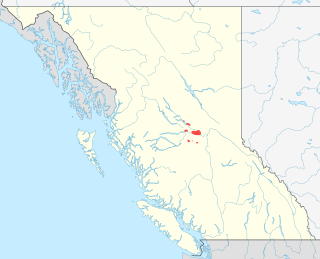
The Okanagan, also called the Okanagan Valley and sometimes the Okanagan Country, is a region in the Canadian province of British Columbia defined by the basin of Okanagan Lake and the Canadian portion of the Okanagan River. It is part of the Okanagan Country, extending into the United States as Okanogan County in north-central Washington. According to the 2016 Canadian census, the region's population is 362,258. The largest populated cities are Kelowna, Penticton, Vernon, and West Kelowna.

The Dakelh or Carrier are the indigenous people of a large portion of the Central Interior of British Columbia, Canada. Another name the Dakelh/Carrier call themselves is Yinka Dene, the Babine-Witsuwitʼen-speaking bands prefer the equivalent Yinka Whut'en.
The Dakelh (ᑕᗸᒡ) or Carrier language is a Northern Athabaskan language. It is named after the Dakelh people, a First Nations people of the Central Interior of British Columbia, Canada, for whom Carrier has been a common English name derived from French explorers naming of the people. Dakelh people speak two related languages. One, Babine-Witsuwit'en, is sometimes referred to as Northern Carrier. The other includes what are sometimes referred to as Central Carrier and Southern Carrier.

Stuart Lake, or Nak'albun in the Carrier (Dakelh) language is a lake situated in the Northern Interior of British Columbia, Canada. The town of Fort St. James is situated by the lake near the outlet. Stuart Lake is 66 kilometres (41 mi) long, 10 kilometres (6.2 mi) wide and relatively shallow, with an average depth of 26 metres (85 ft). There are several privately owned islands on Stuart lake.
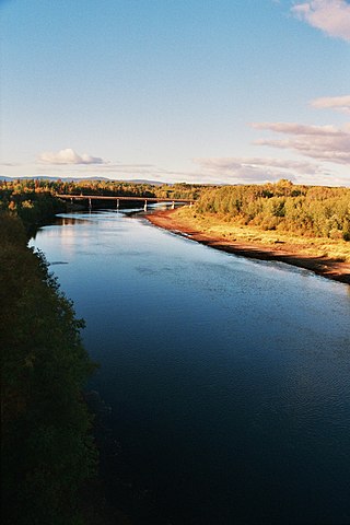
The Nechako River arises on the Nechako Plateau east of the Kitimat Ranges of the Coast Mountains of British Columbia, Canada, and flows north toward Fort Fraser, then east to Prince George where it enters the Fraser River. "Nechako" is an anglicization of netʃa koh, its name in the indigenous Carrier language which means "big river".
The Stuart River or Nak'alkoh is one of the largest tributaries of the Nechako River in northeastern British Columbia, Canada. The Nechako is in turn one the more important tributaries of the Fraser River. The Stuart River flows 187 kilometres (116 mi) from Stuart Lake to its junction with the Nechako River. The river drains a portion of the Nechako Plateau—a gently-rolling region characterized by small lakes and tributaries. Low but impressive ridges interact with the river, creating high bluffs and hoodoos.
Tl'azt'en Nation is a First Nations band located along the north shore of Stuart Lake near the outlet of the Tache River, in the northern interior of British Columbia. The main village belonging to Tl'azt'en Nation is Tache, 60 km north-west of Fort St. James.The small settlements of Middle River (Dzit'lain'li).on Trembleur Lake and Grand Rapids, along the Tache River between Stuart Lake and Trembleur Lake also belong to Tl'azt'en Nation. The main administrative offices are in Tache, as a school - Eugene Joseph Elementary School, Daycare, Head Start, Health Unit, Education Centre/ Learning Centre for Adults, RCMP/ Justice Office, Public Works building that supplies diesel and gasoline, water treatment plant, a newly built youth recreation center (2012), a Catholic and Christian church, one in Old Tache and one in "sunny side", a volunteer fire department with a fire hall; rec sites include a paintball park, a basketball court and a hockey rink. The village of Portage once belonged to Tla'zt'en Nation but separated in 1994 as Yekooche First Nation. The village of Pinchie once belonged to Tl'azt'en Nation separated on March 12, 2019 and is now the Binche Whut'en First Nation Prior to 1988 Tl'azt'en Nation was known as the Stuart-Trembleur band. Tl'azt'en Nation belongs to the Carrier Sekani Tribal Council.
François Lake Provincial Park is a provincial park in British Columbia, Canada, located at the east end of Francois Lake. The total park area is 7,214 hectares. It is about 12 kilometres (7.5 mi) off BC Highway 16, southwest of the town of Fraser Lake. There is no potable water at the site so campers should bring their own.
James McDougall was a nineteenth-century fur trader and explorer, who is remembered for his participation in opening up present-day British Columbia, Canada to European settlement as part of a North West Company expedition to the region, led by Simon Fraser.
Cunningham Lake is in the Omineca region of central British Columbia. By road and trail, the eastern end is about 80 kilometres (50 mi) northwest of Fort St. James. Nancut Creek flows northeast from the lake into Stuart Lake.

The Nadleh Whut'en First Nation is a First Nations government of the Dakelh people, whose territory is located in the Central Interior of British Columbia, Canada, around the east end of Fraser Lake. The nation has seven reserves which Crown-Indigenous Relations and Northern Development Canada refer to as IR#1-9.. Until 1990, it was referred to as the Fraser Lake Indian Band.
The Cheslatta Trail is an ancient land route in British Columbia, Canada, that stretched from the Dakelh villages of Belhk'achek and Sdughachola on Cheslatta Lake to Nadleh Village on Fraser Lake. It was used by the Dakelh people for as a major trade, travel and communication line, until the construction of the Alcan Kenney Dam in 1952 caused flooding of the Cheslatta River and Cheslatta Lake, forcing the Cheslatta people from their lakeside villages.
A grease trail is an overland trade route, part of a network of trails connecting the Pacific coast with the Interior in the Pacific Northwest.
Kwah is the usual English form of the name of the famous Carrier leader Kw'eh. He was born around 1755 and died in 1840. Chief Kw'eh was chief of his Keyoh called Nak'azdli in the late eighteenth and early nineteenth centuries, In his time, few people lived at Nak'azdli. Carrier people from other keyohs were attracted to Kwah's village due to the North West Company fort there, which was established after 1806.
The Cheslatta Carrier Nation or Cheslatta T'En, of the Dakelh or Carrier people (Ta-cullies, meaning "people who go upon water" is a First Nation of the Nechako River at the headwaters of the Fraser River.
The Stellat'en First Nation is the band government of the Stellat'en subgroup of the Dakelh people in the Omineca Country of the Central Interior of British Columbia, Canada, 160 km west of Prince George, B.C.
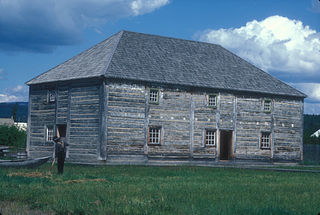
Fort St. James is a district municipality and former fur trading post in northern central British Columbia, Canada. It is located on the south-eastern shore of Stuart Lake in the Omineca Country, at the northern terminus of Highway 27, which connects to Highway 16 at Vanderhoof.
Lejac is a locality on the Canadian National Railway line in the Nechako Country region of British Columbia, located on the south shore of Fraser Lake between the communities of Fraser Lake (W) and Fort Fraser (E).
Southern Carrier, Lower Carrier or locally known as Dakelh is an endangered dialect group of the Athabaskan Carrier language of British Columbia, Canada. The dialects belonging to Southern Carrier roughly correspond to those to the south of Fort St. James. The group is divided into two subgroups, Fraser/Nechakoh and Blackwater which are further subdivided into individual dialects.
References
- ↑ "Nadleh Whut'en words". First Peoples' Heritage, Language and Culture Council . Retrieved February 25, 2011.
- ↑ Fraser Lake & Fort Fraser, Getawaybc.com
- ↑ "On the trail of the fur trade". The Vancouver Sun . November 9, 2007. Retrieved February 25, 2011.