The canton of Bern, or Berne, is one of the 26 cantons forming the Swiss Confederation. Its capital city, Bern, is also the de facto capital of Switzerland. The bear is the heraldic symbol of the canton, displayed on a red-yellow background.

Büren an der Aare is a historic town and a municipality in the Seeland administrative district in the canton of Bern in Switzerland.

Wangen an der Aare is a municipality in the Oberaargau administrative district in the canton of Bern in Switzerland.

Aarberg is a historic town and a municipality in the Seeland administrative district in the canton of Bern in Switzerland.

The Bernese Oberland, sometimes also known as the Bernese Highlands, is the highest and southernmost part of the canton of Bern. It is one of the canton's five administrative regions. It constitutes the Alpine region of the canton and the northern side of the Bernese Alps, including many of its highest peaks, among which the Finsteraarhorn, the highest in both range and canton.

The city of Bern is one of the Zähringer foundations of the late 12th century. By the end of the 13th century, it had acquired de facto imperial immediacy. It became a full member of the Old Swiss Confederacy in 1353, and during the 15th century managed to significantly expand its sphere of influence, notably with the conquest of Aargau in 1415. With the acquisition of Vaud in 1536, Bern became the most powerful city-republic north of the Alps, and one of the leading Protestant cities in early modern Switzerland. The canton of Bern in the Restored Confederacy of 1815 even after the loss of Aargau and Vaud remained the largest Swiss canton, relegated to second rank only with the secession of Jura in 1979. Since 1848 Bern has served as the federal city (capital) of Switzerland.

Muri bei Bern is a municipality in the Bern-Mittelland administrative district in the canton of Bern in Switzerland.

Nidau is a municipality in the Biel/Bienne administrative district in the canton of Bern in Switzerland.

The Nydeggbrücke is a bridge in Bern, Switzerland which connects the eastern part of the old city to the new part. It crosses over the Aare and is located very close to the Bärengraben. It was built in parallel to the Untertorbrücke in 1840, which until then had been the only bridge crossing the Aare. The Nydeggbrücke is in total 190 meters long and took three years to build. It is a Swiss heritage site of national significance.

The Old City is the medieval city center of Bern, Switzerland. Built on a narrow hill bordered on three sides by the river Aare, its compact layout has remained essentially unchanged since its construction during the twelfth to the fifteenth century. Despite a major fire in 1405, after which much of the city was rebuilt in sandstone, and substantial construction efforts in the eighteenth century, Bern's old city has retained its medieval character.

Schadau Castle is a castle on the south side of the Aare near Lake Thun in the city of Thun, Canton Bern, Switzerland. It is a Swiss heritage site of national significance.

The Gerechtigkeitsgasse is one of the principal streets in the Old City of Bern, the medieval city center of Bern, Switzerland. Together with its extension, the Kramgasse, it is the heart of the inner city. Hans Gieng's most famous fountain figure, the statue of Lady Justice on the Gerechtigkeitsbrunnen, commands the view of the street's gentle slopes and curves.

The Junkerngasse is a street in the Old City of Bern, the medieval city center of Bern, Switzerland. It connects the tip of the Aar peninsula to the Münster.

The Herrengasse is one of the streets in the Old City of Bern, the medieval city center of Bern, Switzerland. It was the southernmost street of the old Zähringerstadt of Bern and ended at the first city wall. Three buildings on the Herrengasse are listed on the Swiss inventory of heritage site of national significance and it is part of the UNESCO Cultural World Heritage Site that encompasses the Old City.

The Nydeggstalden is one of the streets in the Old City of Bern, the medieval city center of Bern, Switzerland. It is part of the Nydegg which was part of the medieval industrial section of Bern. It is a semi-circular road running from Gerechtigkeitsgasse toward the Aare river and the Untertorbrücke. It is part of the UNESCO Cultural World Heritage Site that encompasses the Old City.
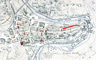
The Postgasse is one of the streets in the Old City of Bern, the medieval city center of Bern, Switzerland. It is part of the Zähringerstadt which was built during the foundation of the city in 1191. It runs from Nydeggstalden near the Aare river in the east to the transverse Kreuzgasse, where the name changes to Rathausgasse. It is part of the UNESCO Cultural World Heritage Site that encompasses the Old City.

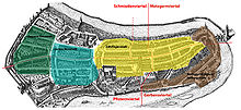
The Zähringerstadt is a historic section in the Old City of Bern in Bern, Switzerland.
The Mattequartier is a historic section in the Old City of Bern in Bern, Switzerland.

The Bundesplatz is the Government Plaza in Bern, the de facto capital city of Switzerland. It is situated in the Old City of Bern, the medieval city center of Bern. It is part of the Innere Neustadt which was built during the second expansion in 1255 to 1260, though the plaza was not built until much later. It is located in front of the Bundeshaus, the Swiss Parliament Building, and it is part of the UNESCO Cultural World Heritage Site that encompasses the Old City.