Nzulezo is a village located near the village of Beyin, 90 kilometers west of Takoradi, in the Jomoro District in the Western Region of Ghana.[1] Nzuleso can also be spelt as "Nzulezu". Over 500 people live in the community.[2]
Nzulezu overlooks Lake Tadane, and is entirely made up of stilts and platforms. In 2000, it was nominated as a UNESCOWorld Heritage Site, and is a major tourist attraction area.[1] The site is increasingly a source of tourism, with tourist coming to experience the village as well as a local alcohol produced in the village.[2]
Etymology
The name "Nzulezo" in the Nzema language means "water surface", and is a village on stilts of "Ewuture" origin situated close to the northwest shore.[3][4] The "Ewuture" maintained the waterways and transportation of goods and people.[3] According to local legend, the village was built by a group of people from Oualata, a city in the ancient Ghana Empire and in present-day Mauritania, which came about from following a snail.[5]
Construction
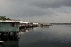
A house built over Lake Tadane.
Nzulezu was built over Lake Tadane. The settlement of Nzulezo consists of stilt-supported structures.[1]
The reason Nzulezo was built over water was for protection and safety during attacks in times of war since it lies five miles inland of the Southwest shores.[3]
The main activities of its inhabitants is agriculture, while fishery plays a secondary role. The lake is perceived by the local population to protect against certain risks (e.g. a fire).[1] The village did have some of the houses partially submerged from a flood in 2009.[6]
Services
The village has a limited number of nurses and health care capacity.[2]
There is a primary school and after primary school learners have to leave the village to go for secondary schools and universities.[7] However, as of 2019 there were a shortage of teachers for the community.[2]
World Heritage Status
This site was added to the UNESCOWorld Heritage Tentative List on January 17, 2000, in the Cultural category.[1]
The village was nominated to become a World Heritage Site for its importance in anthropology: in addition to being one of the few ancient settlements on stilts and platforms left in the world, there is a preserved wealth of local traditions connected with the cult of the lake.[1] Lake Tadane occurs on the banks of all religious rites, and Thursday, is a day sacred to the lake, and it is forbidden to use and work on the lake for any activity throughout the day of Thursday.[1]
Nzulezo Canoe Transport
In recent times the village has been opened to tourism,[8] but with certain constraints (visitations are allowed only once a week).[1] The village can be reached only by canoe; the 5km journey, which crosses the rain forest, takes about an hour. In the village there is a church and a school. As the village is extremely isolated, Nzulezo suffers from numerous health problems, including the vast spread of malaria.[1]
1 2 3 Valsecchi, Pierluigi (2011). Power and state formation in West Africa: Appolonia from the Sixteenth to the Eighteenth Century. Allan Cameron. New York: Palgrave Macmillan. ISBN978-0-230-37069-2. OCLC892799728.
This page is based on this Wikipedia article Text is available under the CC BY-SA 4.0 license; additional terms may apply. Images, videos and audio are available under their respective licenses.