
Tierra del Fuego is an archipelago off the southernmost tip of the South American mainland, across the Strait of Magellan.

Tierra del Fuego, officially the Province of Tierra del Fuego, Antarctica and South Atlantic Islands, is the southernmost, smallest, and least populous Argentine province. The provincial capital city is Ushuaia, from a native word meaning "bay towards the end".

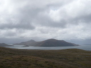
Isla Grande de Tierra del Fuego also formerly Isla de Xátiva is an island near the southern tip of South America from which it is separated by the Strait of Magellan. The western portion (61.4%) of the island is in Chile, while the eastern portion is in Argentina. It forms the major landmass in an extended group of islands or archipelago also known as Tierra del Fuego.

Beagle Channel is a strait in the Tierra del Fuego Archipelago, on the extreme southern tip of South America between Chile and Argentina. The channel separates the larger main island of Isla Grande de Tierra del Fuego from various smaller islands including the islands of Picton, Lennox and Nueva; Navarino; Hoste; Londonderry; and Stewart. The channel's eastern area forms part of the border between Chile and Argentina and the western area is entirely within Chile.

Hoste Island is one of the southernmost islands in Chile, lying south, across the Beagle Channel, from Isla Grande de Tierra del Fuego and west of Navarino Island, from which it is separated by the Murray Channel. It is named after William Hoste, one of Lord Nelson's protégés.

Picton, Lennox and Nueva form a group of three islands at the extreme southern tip of South America, in the Chilean commune of Cabo de Hornos in Antártica Chilena Province, Magallanes and Antártica Chilena Region. Located in the Tierra del Fuego archipelago, they lie east of Navarino Island and are separated from the Argentine part of Isla Grande in the north by the Beagle Channel. They have an area of 170.4 km2 (Lennox), 105.4 km2 (Picton), 120.0 km2 (Nueva).

The Beagle conflict was a border dispute between Chile and Argentina over the possession of Picton, Lennox and Nueva islands and the scope of the maritime jurisdiction associated with those islands that brought the countries to the brink of war in 1978.

The Hermite Islands are the islands Hermite, Herschel, Deceit and Hornos as well as the islets Maxwell, Jerdán, Arrecife, Chanticleer, Hall, Deceit (islet), and Hasse at almost the southernmost end of South America. The smallest and southernmost of the major islands is Hornos Island, the location of Cape Horn. The islands are located south of the Wollaston Islands and separated from them by the Franklin Channel. The islets Terhalten, Sesambre, Evout and Barnevelt are located easterly and are not considered part of the Hermite islands.

Navarino Island is a large Chilean island, with an area of 2,514 km2 (971 sq mi) and a coastline of 510 km (320 mi). It is located between Isla Grande de Tierra del Fuego, to the north, and Cape Horn, to the south. The island forms part of the Commune of Cabo de Hornos, the southernmost commune in Chile and in the world, belonging to Antártica Chilena Province in the XII Region of Magallanes and Chilean Antarctica. Its population is concentrated primarily in the communal capital, Puerto Williams, and in small settlements like Puerto Navarino, Río Guanaco and Puerto Toro. The highest point of the island is Pico Navarino at 1,195 m (3,921 ft). The island is a popular destination for fly-fishers.
Londonderry Island is an island in the Magallanes Region at the western end of the Beagle Channel and Darwin Sound. The island was named by the captain of HMS Beagle, Robert FitzRoy, whose maternal grandfather was The 1st Marquess of Londonderry, an Ulster-Scots peer.
The Wollaston Islands are a group of islands in Chile south of Navarino Island and north of Cape Horn and east of the Hoste Island. The islands are Grevy, Bayly, Wollaston and Freycinet, as well as the islets Dédalo, Surgidero, Diana, Otarie, Middle and Adriana. The islands are part of Cabo de Hornos National Park.

Gordon Island is an island in the Tierra del Fuego archipelago located between the Tierra del Fuego and the Hoste Island. It divides the Beagle Channel in two arms, the Northwest arm or Pomar Channel and the Southwest arm.
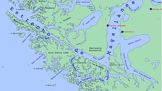
Magdalena Channel is a Chilean channel joining the Strait of Magellan with the Cockburn Channel and is part of a major navigation route which ultimately connects with the Beagle Channel. It separates Capitán Aracena Island from the westernmost portion of Isla Grande de Tierra del Fuego, and crosses Alberto de Agostini National Park. It is flanked by mountains, the chief of which is Monte Sarmiento. Like the Abra Channel and the Bárbara Channel farther west, it joins the western part of the Strait of Magellan directly to the Pacific Ocean.
The region of the Beagle Channel, explored by Robert FitzRoy in the 1830s, was one of the last to be colonized by Chile and Argentina. The cold weather, the long distances from other inhabited regions, and the shortage of transport and subsistence, kept it far from the governmental task.

The Treaty of Peace and Friendship of 1984 between Chile and Argentina was signed into agreement at the Vatican on 29 November 1984.
The southern coast of Chile presents a large number of fjords and fjord-like channels from the latitudes of Cape Horn to Reloncaví Estuary. Some fjords and channels are important navigable channels providing access to ports like Punta Arenas, Puerto Chacabuco and Puerto Natales.

Tierra del Fuego National Park is a national park on the Argentine part of the island of Tierra del Fuego, within Tierra del Fuego Province in the ecoregion of Patagonic Forest and Altos Andes, a part of the subantarctic forest. Established on 15 October 1960 under the Law 15.554 and expanded in 1966, it was the first shoreline national park to be established in Argentina.

The Cockburn Channel is a channel that separates the Brecknock Peninsula, which is the westernmost projection of the Isla Grande de Tierra del Fuego, from Clarence Island, Capitán Aracena Island and other minor islands in Chile. It is located at 54°20′S71°30′W and extends 40 miles (64 km) east from the open Pacific Ocean to Magdalena Channel. The channel is part of a major waterway connecting the Strait of Magellan to the Beagle Channel: Magdalena Channel, Cockburn Channel, Brednock Pass, Ballenero Channel, Beagle Channel.

Between 1883 and 1906 Tierra del Fuego experienced a gold rush attracting many Chileans, Argentines and Europeans to the archipelago, including many Dalmatians. The gold rush led to the formation of the first towns in the archipelago and fueled economic growth in Punta Arenas. After the gold rush was over, most gold miners left the archipelago, while the remaining settlers engaged in sheep farming and fishing. The rush made a major contribution to the genocide of the indigenous Selk'nam people.
The Ballenero Channel runs between the Tierra del Fuego and Cook, Londonderry and the Stewart Islands and joints the Pomar Channel and O'Brien Channel to the Desolada Bay and to the Pacific Ocean.
