
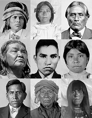
The Tohono Oʼodham are a Native American people of the Sonoran Desert, residing primarily in the U.S. state of Arizona and the northern Mexican state of Sonora. The United States federally recognized tribe is the Tohono Oʼodham Nation.

The San Xavier Indian Reservation is an Indian reservation of the Tohono O’odham Nation located near Tucson, Arizona, in the Sonoran Desert. The San Xavier Reservation lies in the southwestern part of the Tucson metropolitan area and consists of 111.543 sq mi (288.90 km2) of land area, about 2.5 percent of the Tohono O’odham Nation. It had a 2000 census resident population of 2,053 persons, or 19 percent of the Tohono O’odham population.
Oʼodham or Papago-Pima is a Uto-Aztecan language of southern Arizona and northern Sonora, Mexico, where the Tohono Oʼodham and Akimel Oʼodham reside. In 2000 there were estimated to be approximately 9,750 speakers in the United States and Mexico combined, although there may be more due to underreporting.
The Akimel O'odham, also called the Pima, are a group of Native Americans living in an area consisting of what is now central and southern Arizona, as well as northwestern Mexico in the states of Sonora and Chihuahua. The majority population of the two current bands of the Akimel O'odham in the United States are based in two reservations: the Keli Akimel Oʼodham on the Gila River Indian Community (GRIC) and the On'k Akimel O'odham on the Salt River Pima-Maricopa Indian Community (SRPMIC).
Indigenous peoples of Arizona are the Native American people who currently live or have historically lived in what is now the state of Arizona. There are 22 federally recognized tribes in Arizona, including 17 with reservations that lie entirely within its borders. Reservations make up over a quarter of the state's land area. Arizona has the third largest Native American population of any U.S. state.
Chicken scratch is a kind of dance music developed by the Tohono O'odham people. The genre evolved out of acoustic fiddle bands in southern Arizona, in the Sonoran desert. These bands began playing European and Mexican tunes, in styles that include the polka, schottisch and mazurka.

The Salt River Pima–Maricopa Indian Community (SRPMIC) comprises two distinct Native American tribes—the Pima and the Maricopa —many of whom were originally part of the Halchidhoma (Xalchidom) tribe. The community was permanently created by an Executive Order of US President Rutherford Birchard Hayes on June 14th, 1879. The community area includes 53,600 acres (217 km2), of which 19,000 remain a natural preserve. As of 2022, the total population is 7,386. The community is a federally recognized tribe located in Arizona.
Ofelia Zepeda is a Tohono O'odham poet and intellectual. She is Regents' Professor of Tohono O'odham language and linguistics and Director of the American Indian Language Development Institute (AILDI) at The University of Arizona. Zepeda is the editor for Sun Tracks, a series of books that focuses on the work of Native American artists and writers, published by the University of Arizona Press.

The Tohono Oʼodham Nation is the collective government body of the Tohono Oʼodham tribe in the United States. The Tohono Oʼodham Nation governs four separate pieces of land with a combined area of 2.8 million acres (11,330 km2), approximately the size of Connecticut and the second largest Indigenous land holding in the United States. These lands are located within the Sonoran Desert of south central Arizona and border the Mexico–United States border for 74 miles (119 km) along its southern border. The Nation is organized into 11 local districts and employs a tripartite system of government. Sells is the Nation's largest community and functions as its capital. The Nation has approximately 34,000 enrolled members, the majority of whom live off of the reservations.

The Tohono Oʼodham Indian Reservation, is an Indian reservation of the Tohono Oʼodham Nation located in Arizona, United States. The reservation had a total 2000 census population of 10,787. The reservation has a land area of 4,340.984 square miles (11,243.098 km2), 97.48 percent of the Tohono Oʼodham Nation total area. The reservation encompasses portions of central Pima, southwestern Pinal, and southeastern Maricopa Counties.

Topawa is a census-designated place and unincorporated community in Pima County, Arizona, United States. The population was 315 as of the 2020 census. Topawa is located on the Tohono O'odham Nation reservation, 7.5 miles (12.1 km) south-southeast of Sells. Topawa has a post office with ZIP code 85639.
The Tohono Oʼodham High School is a high school in unincorporated Pima County, Arizona, in the Tohono Oʼodham Indian Reservation. Located along Arizona State Route 86, near Sells, it is operated directly by the Bureau of Indian Education. Feeder schools include the San Simon day school and the Santa Rosa Boarding School, also operated by the BIA. It was established in the mid-1980s as the remaining reservations in Arizona finally received their own high schools.

Tohono Oʼodham Community College (TOCC) is a public tribal land-grant community college in Sells, Arizona. TOCC's student body is 88 percent American Indian/Alaskan Native. Tohono Oʼodham Community College serves approximately 216 students. The college's faculty and staff is 57 percent American Indian, half of whom are Oʼodham.
Etoi Ki is a summit in the Pima County, Arizona, United States. It is west of Kitt Peak National Observatory and northwest of the unincorporated community of Sells. It is rises adjacent to Arizona State Route 86 across the highway from Bird Nest Hill on the Tohono O'odham Indian Reservation, about 62 miles (100 km) west of Tucson and 24 miles (39 km) north of the Mexican border.
Kui Tatk is a populated place located on the Tohono O'odham Indian Reservation in Pima County, Arizona, United States. It has an estimated elevation of 2,044 feet (623 m) above sea level. Its name means "mesquite root" in the Tohono O'odham language. Historically it has also been known by the variant, Kvitatk. It has also incorrectly been identified as Iron Pipe, which is the name of a village which sprang up around a steam pump built by miners about a mile away. The name, and its current spelling, was reached as a decision by the Board on Geographic Names in 1941. The original Indian settlement was abandoned in the 1850s, when its inhabitants migrated to different locations such as Gu Oidak, Pan Tak, and Gu Chuapo.
Kupk is a populated place located on the Tohono O'odham Indian Reservation in Pima County, Arizona, United States. It has an estimated elevation of 1,844 feet (562 m) above sea level. Its name is derived from the Tohono O'odham ku:pik, meaning dam or dike.
Pitoikam is a populated place situated on the Tohono O'odham Indian Reservation in Pima County, Arizona, United States. Pitoikam means "sycamore place" in the O'odham language. It has also been known as Fresnal, Fresnal Well, Pitoi Kam, and Pitoikam Ranch. It officially became known as Pitoikam as a result of a Board on Geographic Names decision on April 10, 1941, which was the traditional name of the village and the name which the residents preferred to use. It has an estimated elevation of 3,068 feet (935 m) above sea level.

Queens Well is a populated place in Pima County, Arizona. It has an estimated elevation of 2,041 feet (622 m) above sea level. Queens Well is located in the Schuk Toak District on the east side of the Tohono O’odham Nation. The area has had multiple solar powered wells installed in the 1970's and 1980's.

Wahak Hotrontk also known as San Simon (O'odham) name translates as "Road Dips", is a census-designated place in Pima County, in the U.S. state of Arizona. The population was 120 as of the 2020 census. It is located along Arizona State Route 86 on the Tohono O'odham Nation reservation.
Stotonyak is a populated place situated on the San Xavier Indian Reservation in Pima County, Arizona, United States. It has an estimated elevation of 1,919 feet (585 m) above sea level. To differentiate from the village of a similar name on the Gila River Indian Community, the Office of Indian Affairs recommended that this village use the Papago, or Tohono O'odham spelling, while the Gila River reservation village use the Pima, or Akimel O'otham spelling, Stotonic. The recommendation was followed by the Board on Geographic Names in their 1941 decision. In the O'odham language, stotonyak means "many ants.