
Stroud is a market town and civil parish in Gloucestershire, England. It is the main town in Stroud District. The town's population was 13,500 in 2021.

Painswick is a town and civil parish in the Stroud District in Gloucestershire, England. Originally the town grew from the wool trade, but it is now best known for its parish church's yew trees and the local Rococo Garden. The village is mainly constructed of locally quarried Cotswold stone. Many of the buildings feature south-facing attic rooms once used as weavers' workshops.

Winterbourne is a large village in South Gloucestershire, England, situated just beyond the north fringe of Bristol. The village had a population of 8,965 according to the 2011 census. This has risen to 10,250 at the 2021 Census. The civil parish of Winterbourne is centred on the village and includes the neighbouring communities of Winterbourne Down, Hambrook and Frenchay. To the north-east is the village of Frampton Cotterell and to the west lies the town of Bradley Stoke.

Nailsworth is a town and civil parish in the Stroud District in Gloucestershire, England, lying in one of the Stroud Valleys in the Cotswolds, on the A46 road, 4 miles (6.4 km) south of Stroud and about 25 miles (40 km) north-east of Bristol and Bath. The parish had a population of 5,794 at the 2011 census.

Much Marcle is a village and civil parish in Herefordshire, England, located 7 miles (11 km) north-east of Ross-on-Wye. The 2011 Census recorded the parish's population as 660. The name Marcle comes from the Anglo-Saxon word for a boundary field, mearc-leah. Much, in this case, means large or great, from the Middle English usage of the word.

Coalpit Heath is a small village in the civil parish of Westerleigh and Coalpit Heath, in the South Gloucestershire district, in the ceremonial county of Gloucestershire, England, south of Yate and east of Frampton Cotterell.
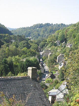
Chalford is a large village in the Frome Valley of the Cotswolds in Gloucestershire, England. It is to the southeast of Stroud about four miles upstream. It gives its name to Chalford parish, which covers the villages of Chalford, Chalford Hill, France Lynch, Bussage and Brownshill, spread over two square miles of the Cotswold countryside. At this point the valley is also called the Golden Valley.
Great Witley is a village and civil parish in the Malvern Hills District in the northwest of the county of Worcestershire, England. It is situated around ten miles to the north west of the city of Worcester. The parish had a population of 743 in 2021.

Arlingham is a village and civil parish in the Stroud District of Gloucestershire, England. The 2021 Census recorded a parish population of 533. The parish contains the hamlets of Milton End, Overton and Priding. The next parish to the east is Fretherne with Saul.

Sheepscombe is a small village in the civil parish of Painswick, in the Stroud district, in the county of Gloucestershire, England. Sheepscombe is located some 6.5 miles (10 km) south-east of the city of Gloucester, 6 miles (10 km) north-east of the town of Stroud, and 1.5 miles (2 km) east of the village of Painswick. It lies in a narrow valley, hidden behind the Cotswold scarp, and just off the A46 and B4070 roads.

Eastington is a village and civil parish in Gloucestershire, England. It lies 4 miles west of Stroud and 9 miles south of Gloucester at the entrance to the Stroud Valley. It is west of the town of Stonehouse and south of Junction 13 of the M5 motorway and the A38 and A419 roads. Since the M5 and its access roads were opened, the main road no longer runs through the village.

Norman Jewson was an English architect-craftsman of the Arts and Crafts movement, who practised in the Cotswolds. He was a distinguished, younger member of the group which had settled in Sapperton, Gloucestershire, a village in rural southwest England, under the influence of Ernest Gimson. Surviving into old age, he brought their ideas and working methods into the second half of the twentieth century. His book of reminiscences has become established as a minor classic of the English Arts and Crafts movement. His repair of the Tudor Owlpen Manor in 1925–26 is often regarded as his most representative and successful work.

Tarrington is a small village in Herefordshire, England located halfway between Ledbury and Hereford on the A438 road.

Nympsfield is a village and civil parish in the English county of Gloucestershire. It is located around four miles south-west of the town of Stroud. As well as Nympsfield village, the parish contains the hamlet of Cockadilly. The population taken at the 2011 census was 382.
Alfred Hoare Powell (1865–1960) was an English Arts and Crafts architect, and designer and painter of pottery.

Leonard Stanley, or Stanley St.Leonard, is a village and parish in Gloucestershire, England, 95 miles (150 km) west of London and 3.5 miles (5.5 km) southwest of the town of Stroud. Situated beneath the Cotswold escarpment overlooking the Severn Vale, the surrounding land is mainly given over to agricultural use. The village is made up of some 600 houses and has an estimated population of 1,545 as of 2019. The hamlet of Stanley Downton lies less than a mile to the north and lies within the parish. In 1970, the village was twinned with the commune of Dozulé in the Calvados region of Normandy, northern France.

South Leigh is a village in the civil parish of South Leigh and High Cogges, in the West Oxfordshire district, in Oxfordshire, England, on Limb Brook, a small tributary of the River Thames, about 2+1⁄2 miles (4 km) east of Witney. The 2011 Census recorded the parish's population as 336. On 1 January 2024 the parish was renamed from "South Leigh" to "South Leigh and High Cogges".

Eastcombe is a village in Stroud District in Gloucestershire, England.

Covenham St Bartholomew is a village in the East Lindsey district of Lincolnshire, England. It is situated approximately 5 miles (8 km) north from Louth. The southern part of the village adjoins Covenham St Mary; both villages are ecclesiastical parishes and part of the civil parish of Covenham.

