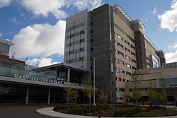
Oakville Trafalgar Memorial Hospital | |
---|---|
Halton Healthcare | |
Geography | |
Location | Oakville, Halton Region, Ontario, Canada |
Coordinates | 43°27′03.5″N079°45′49.5″W / 43.450972°N 79.763750°W |
Organization | |
Care system | Public Medicare (Canada) (OHIP) |
Type | Community |
Affiliated university | Michael G. DeGroote School of Medicine |
Services | |
Emergency department | Yes |
Beds | 457 [1] |
Helipad | TC LID: CTM9 |
History | |
Opened | 1937, 1950 on Reynolds St., 2015 on present site |
Links | |
Website | www |
Lists | Hospitals in Canada |
The Oakville Trafalgar Memorial Hospital is a full-service acute care community hospital located at 3001 Hospital Gate in Oakville, Ontario. It offers a comprehensive range of primary and secondary care services in addition to some tertiary services. It is operated by Halton Healthcare, an organization which also operates Georgetown Hospital and Milton District Hospital.
The hospital was designed by Parkin Architects and Adamson Associates and built by a joint venture of EllisDon and Carillion. [3] On December 13, 2015 the hospital moved from 327 Reynolds Street (now Oakville Trafalgar Community Centre) to 3001 Hospital Gate near Dundas Street and Third Line. [4]
OTMH has more than 15,000 inpatients each year, while over 240,000 patients visit its outpatient areas. There are 2,300 births a year. [5] The hospital's busy 24-hour emergency department experiences more than 70,000 visits annually. [5]
The hospital is supported by the Oakville Hospital Foundation and the Oakville Hospital Volunteer Association which raises funds to purchase equipment for the hospital. [6] The hospital is affiliated with the Michael G. DeGroote School of Medicine at McMaster University. [7]
Oakville Trafalgar Memorial Hospital is a terminal for three Oakville Transit bus routes. Oakville Transit runs Route 3 and 3A, Third Line, with 20 minute service during peak weekday hours and 30 minutes outside of them during the day, 40 minutes in early morning, later hourly at night, on weekdays. Half hourly during the day, hourly at night on Saturdays, and hourly during the day on Sundays and holidays, to and from the northern terminus, Oakville Trafalgar Memorial Hospital. [8] Oakville Transit also runs Route 5, Dundas Street, via Oakville Trafalgar Memorial Hospital, with 15 minute service during peak weekday hours, 30 minutes outside of them during the day, and hourly at night on weekdays. On Saturdays, half hourly during the day, hourly at night, though the night frequency starts earlier compared to 3 Third Line. On Sundays, half hourly throughout the day, though busses usually start late in the morning; a bit before 8 am. [9] [10] Oakville Trafalgar Memorial Hospital's 3 hospital entrances' bus stops are accessible. [11]
Oakville Trafalgar Memorial Hospital's three hospital entrances' bus stops are accessible. Oakville Transit runs Care-a-van services to and from any point requested, which are run by fully accessible transit vehicles. [11] [12]
The future planned Dundas BRT will run directly south of the Oakville Trafalgar Memorial Hospital on Dundas Street, a planned bus rapid transit line from Kipling Terminal in Etobicoke, Toronto, connecting to other services; TTC Line 2 (subway), GO Transit Milton Line (regional rail), and GO Transit, MiWay, and TTC busses. [13] [14] running on Dundas Street with major connections such as Cooksville with the Hurontario LRT/Hazel McCallion and the Milton lines, University of Toronto Mississauga, Uptown Core, Hwy 407-Dundas Carpool, along the way all the way to Waterdown Gateway Highway 6 (Waterdown Road) in Waterdown, Hamilton. It will significantly increase the transit accessibility of the hospital. Some other information hasn't been confirmed yet as of September 2024. [15] [16]
Oakville Trafalgar Memorial Hospital is located north of Dundas Street, west of Third Line, east of Hospital Gate, and south of William Halton Parkway. It is south of Highway 407, with the nearby interchanges with the Highway 407 being at Bronte Road and Highway 407, as well as Neyagawa Boulevard and Highway 407. [17] Neyagawa Boulevard is planned to be extended to Milton adding extra access to the hospital. William Halton Parkway is also being extended from Neyagawa Boulevard to Third Line, therefore adding even more access to the hospital. [18]
Oakville is a town and lower-tier municipality in Halton Region, Ontario, Canada. It is located on Lake Ontario between Toronto and Hamilton. At its 2021 census the town had a population of 213,759, with an estimated 233,700 people as of 2024, making it Ontario's largest town. Oakville is part of the Greater Toronto Area and one of the most densely populated areas of Canada. According to the town, about 36% do not have English as their mother tongue, and land available for culture and recreation is over 300,000 m (1,000,000 ft).
Milton is a town in Southern Ontario, Canada, and part of the Halton Region in the Greater Toronto Area. Between 2001 and 2011, Milton was the fastest growing municipality in Canada, with a 71.4% increase in population from 2001 to 2006 and another 56.5% increase from 2006 to 2011. In 2016, Milton's census population was 110,128 with an estimated growth to 228,000 by 2031. It remained the fastest growing community in Ontario but was deemed to be the sixth fastest growing in Canada at that time.
King's Highway 403, or simply Highway 403, is a 400-series highway in the Canadian province of Ontario that travels between Woodstock and Mississauga, branching off from and reuniting with Highway 401 at both ends and travelling south of it through Hamilton and Mississauga. It is concurrent with the Queen Elizabeth Way (QEW) for 22 km (14 mi) from Burlington to Oakville. The Highway 403 designation was first applied in 1963 to a short stub of freeway branching off the QEW at Burlington, and the entire route was completed on August 15, 1997, when the section from Brantford to the then-still independent Town of Ancaster was opened to traffic. The section of Highway 403 between Woodstock and Burlington was formally dedicated as the Alexander Graham Bell Parkway on April 27, 2016, in honour of Alexander Graham Bell.
Milton is one of the seven train lines of the GO Transit system in the Greater Toronto Area, Ontario, Canada. It extends from Union Station in Toronto to Milton, by way of Mississauga. It opened on October 25, 1981.
MiWay, also known as Mississauga Transit and originally as Mississauga Transit Systems, is the municipal public transport agency serving Mississauga, Ontario, Canada, and is responsible to the city's Transportation and Works Department. MiWay services consist of two types of bus routes: MiLocal, local buses that make frequent stops, and MiExpress, express buses between major destinations. MiWay is the primary operator along the Mississauga Transitway, a dedicated east–west bus-only roadway.
Oakville Transit is the public transportation provider in Oakville, Ontario, Canada since 1972. It is a department of the town and a member of the Canadian Urban Transit Association. It offers the typical conventional bus service, a para-transit service called care-A-van, and two on-demand shared ride services in North and Southeast Oakville; Home to Hub and the Ride On-Demand Pilot program. The care-A-van and Ride On-Demand services take riders directly to a specific address while the Home to Hub service takes riders to designated transit hubs near their location.
Burlington Transit is the public transport provider in the city of Burlington, Ontario, Canada. Services began in September 1975, after the city had been served by neighbouring systems including Hamilton Street Railway (HSR) and former subsidiary Canada Coach Lines, as well as "local" services to and from Toronto once provided by Gray Coach Lines and GO Transit along Lakeshore Road.
Milton Transit is the public transit system in the town of Milton, Ontario, Canada. Milton is in Halton Regional Municipality, part of the Greater Toronto Area.
Oakville GO Station is a GO Transit railway station and bus station in Oakville, Ontario, Canada. It is colocated and shares platforms with Via Rail's Oakville railway station.
James Wilfred Snow was a politician in Ontario, Canada. He was a Progressive Conservative Party member of the Legislative Assembly of Ontario from 1967 to 1985 who represented the GTA ridings of Halton East and Oakville. He served as a cabinet minister in the governments of Bill Davis and Frank Miller.
The CN Halton Subdivision is a major railway line in Southern Ontario, Canada. It is owned and operated by the Canadian National Railway (CN).
Halton was a provincial electoral district in Central Ontario, Canada. It elected one member to the Legislative Assembly of Ontario.
Square One Bus Terminal is a GO Transit intercity bus terminal located in central Mississauga, Ontario, Canada. It is situated directly across Rathburn Road West from the City Centre Transit Terminal and the Square One Shopping Centre.
Winston Churchill Boulevard is a long north-south roadway that predominantly forms the western boundary of Peel Region with the eastern boundaries of Halton Region and Wellington County, in Ontario, Canada. The road begins at Lakeshore Road in the south at the boundaries of the City of Mississauga the Town of Oakville, and ends in Caledon at East Garafraxa-Caledon Townline. The road is named in honour of British Prime Minister Sir Winston Churchill.
GO Transit bus services are provided throughout the Greater Toronto and Hamilton Area and the Greater Golden Horseshoe. In 2023, the system had a ridership of 15,229,800.
The Dundas Street bus rapid transit is a proposed bus rapid transit (BRT) corridor proposed by Metrolinx for the western part of the Greater Toronto and Hamilton Area in Southern Ontario, Canada. It is part of the regional transportation plan The Big Move. Metrolinx currently refers to the project as Dundas BRT without the word "Street". The City of Mississauga used the brand Dundas Connects during the development phase.
Burnhamthorpe Road is a major arterial road in the cities of Toronto and Mississauga, Ontario; beginning at Dundas Street, near Islington Avenue, running west and becoming a rural road in the Town of Oakville, where it terminates at Tremaine Road, where it changes name.
Dundas Street is a major historic arterial road in Ontario, Canada. The road connects the city of Toronto with its western suburbs and several cities in southwestern Ontario. Three provincial highways—2, 5, and 99—followed long sections of its course, although these highway segments have since been downloaded to the municipalities they passed through. Originally intended as a military route to connect the shipping port of York to the envisioned future capital of London, Ontario, the street today connects Toronto landmarks such as Yonge–Dundas Square and the city's principal Chinatown to rural villages and the regional centres of Hamilton and London.
Lisgar is a residential neighbourhood in the city of Mississauga, Ontario, Canada. It is located in the extreme northwestern corner of the city, bordering the larger Meadowvale district to the east and the Churchill Meadows neighbourhood to the south. It is named after the former hamlet located at the corner of Winston Churchill Boulevard and Derry Road, which is actually outside the present neighbourhood in Meadowvale.