Related Research Articles

Gila Bend, founded in 1872, is a town in Maricopa County, Arizona, United States. The town is named for an approximately 90-degree bend in the Gila River, which is near the community's current location. As of the 2020 census, the population of the town was 1,892.

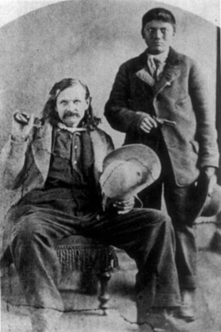
Olive Ann Oatman was a white American woman celebrated in her time for her captivity and later release by Native Americans in the Mojave Desert region when she was a teenager. She later lectured about her experiences.
John W. "Jack" Swilling was an early pioneer in the Arizona Territory. He is commonly credited as one of the original founders of the city of Phoenix, Arizona. Swilling also played an important role in the opening of the central Arizona highlands to white settlement. His discoveries resulted in a gold rush to the region, and this in turn led to the establishment of Arizona's first territorial capital at the mining town of Prescott.

Stanwix Station, in western Arizona, was a stop on the Butterfield Overland Mail Stagecoach line built in the later 1850s near the Gila River about 80 miles (130 km) east of Yuma, Arizona. Originally the station was called Flap Jack Ranch later Grinnell's Ranch or Grinnell's Station. In 1862, Grinnell's was listed on the itinerary of the California Column in the same place as Stanwix Ranch which became the site of the westernmost skirmish of the American Civil War. A traveler in 1864, John Ross Browne, wrote Grinnell's was six miles southwest of the hot springs of Agua Caliente, Arizona.
Rancho Valle de San Felipe was a 9,972-acre (40.36 km2) Mexican land grant in present-day San Diego County, California given in 1846 by Governor Pío Pico to Felipe Castillo. The grant was located in the San Felipe Valley in the Laguna Mountains east of present-day Julian.
The San Antonio–San Diego Mail Line, also known as the Jackass Mail, was the earliest overland stagecoach and mail operation from the Eastern United States to California in operation between 1857 and 1861. It was created, organized and financed by James E. Birch the head of the California Stage Company. Birch was awarded the first contract for overland service on the "Southern Route", designated Route 8076. This contract required a semi-monthly service in four-horse coaches, scheduled to leave San Antonio and San Diego on the ninth and the 24th of each month, with 30 days allowed for each trip.
The Butterfield Overland Mail was a transport and mail delivery system that employed stagecoaches that travelled on a specific route between St. Louis, Missouri and San Francisco, California and which passed through the New Mexico Territory. It was created by the United States Congress on March 3, 1857, and operated until March 30, 1861. The route that was operated extended from where the ferry across the Colorado River to Fort Yuma Station, California was located, through New Mexico Territory via, Tucson to the Rio Grande and Mesilla, New Mexico then south to Franklin, Texas, midpoint on the route. The New Mexico Territory mail route was divided into two divisions each under a superintendent. Tucson was the headquarters of the 3rd Division of the Butterfield Overland Mail Company. Franklin Station in the town of Franklin,, was the headquarters of the 4th Division.

Maricopa Wells is a former place (locale) situated in Pinal County, Arizona. It has an estimated elevation of 1,093 feet (333 m) above sea level. Historically, it was an oasis around a series of watering holes in the Sierra Estrella, eight miles north of present-day Maricopa, Arizona, and about a mile west of Pima Butte. It developed as a trading center and stopping place for travelers in the mid to late 19th century.

Agua Caliente in Maricopa County, Arizona on the border with Yuma County, is a place north of the Gila River near Hyder, Arizona. Named 'Santa Maria del Agua Caliente' in 1744 by Father Jacob Sedelmayer. In 1775, Father Francisco Garces used the current short form. The location was the site of a resort established at the site of nearby hot springs. Agua Caliente, a name derived from Spanish meaning "hot water", received its name from nearby hot springs which were originally used by the local Indigenous population.
Griswell's or Griswell's Station was a stagecoach station of the Butterfield Overland Mail located along the Gila River in Arizona. It was located 12 miles east of Peterman's Station and 15 miles west of Flap Jack Ranch Station.
Burke's Station was a stagecoach station on the Butterfield Overland Mail route in Arizona. It was named in 1858 after Patrick Burke, the first proprietor of the station. It was temporarily closed when the Butterfield line shut down during 1861 due to the American Civil War. Burke's was located 9.43 miles from Grinnels Ranch approximately halfway over the difficult route to Oatman Flat. It was afterward purchased by King Woolsey. Later revived as a stagecoach station in 1866, it was purchased by William Fourr who also sold flour and groceries there and acquired a dairy herd. Then in 1869, Fourr sold Burkes Station and it continued as a stage station until the Southern Pacific Railroad arrived in Arizona, making it obsolete. After closure as a stage station, the name was changed to 'Burkes Ranch' and by 1900 to 'Alpha' (AZ-T101).

Vallecito, in San Diego County, California, is an oasis of cienegas and salt grass along Vallecito Creek and a former Kumeyaay settlement on the edge of the Colorado Desert in the Vallecito Valley. Its Spanish name is translated as "little valley". Vallecito was located at the apex of the gap in the Carrizo Badlands created by Carrizo Creek and its wash in its lower reach, to which Vallecito Creek is a tributary. The springs of Vallecito, like many in the vicinity, are a product of the faults that run along the base of the Peninsular Ranges to the west.
Murderer's Grave Station is a historic locale, later called Kinyon Station and Kenyon Station was a stagecoach station of the Butterfield Overland Mail located along the Gila River in Arizona. The site was located 20 miles east of Oatmans Flat Station and 15 miles west of Gila Ranch Station. It was located along the Gila River near the present site of the Painted Rock Reservoir
Oatman Flat Station, later Fourr's Stage Station, was a stagecoach station of the Butterfield Overland Mail located along the Gila River in Maricopa County, Arizona. The site was located 20 miles (32 km) east of Flap-Jack Ranch and 20 miles (32 km) west of Murderer's Grave Station, near the Gila River at Oatman Flat. It is to the east of the Oatman Grave, where the family of Olive Oatman was buried following their massacre on the Southern Emigrant Trail by Yavapai in 1851.

Gillett, Arizona, is a ghost town in Yavapai County, Arizona, United States. It has an estimated elevation of 1,362 feet (415 m) above sea level. Historically, it was a stagecoach station, and then a settlement formed around an ore mill serving the Tip Top Mine, on the Agua Fria River in Yavapai County in what was then Arizona Territory. It was named for the mining developer of the Tip Top Mine, Dan B. Gillett and is spelled incorrectly as Gillette on U. S. Topographic Maps and elsewhere.
References
- ↑ U.S. Geological Survey Geographic Names Information System: Oatman Flat
- ↑ U.S. Geological Survey Geographic Names Information System: Oatman Grave
- ↑ Neal Du Shane, Oatman Massacre Graves and Fourr Ranch Cemetery, Arizona Pioneer & Cemetery Research Project, Internet Presentation Version 120612-1, December 6, 2012 accessed October 13, 2014.
- ↑ Hall, E. Hepple (1866). The great West: railroad, steamboat, and stage guide and hand-book, for travellers, miners, and emigrants to the western, northwestern, and Pacific states and territories. New York: D. Appleton and Company. p. 93 – via HathiTrust.
- ↑ The Fourr Ranch Summary in 2006 by M. Lesko. Updated in 2011 by T. Johnson from gvrhc.org accessed October 13, 2014