
Occupacia Creek is a tributary of the Rappahannock River in Essex County, Virginia. [1] [2] [3] The drainage area of the creek is 29.3 square miles. [4]
Occupacia Creek is a tributary of the Rappahannock River in Essex County, Virginia. [1] [2] [3] The drainage area of the creek is 29.3 square miles. [4]

Monongalia County, known locally as Mon County, is a county located in the U.S. state of West Virginia. As of the 2020 census, the population was 105,822, making it West Virginia's third-most populous county. Its county seat is Morgantown. The county was founded in 1776. Monongalia County is included in the Morgantown, WV Metropolitan Statistical Area, and is the largest county in North-Central West Virginia. It is part of the Pittsburgh media market.
Middlesex County is a county located on the Middle Peninsula in the U.S. state of Virginia. As of the 2020 census, the population was 10,625. Its county seat is Saluda.

Isle of Wight County is a county located in the Hampton Roads region of the U.S. state of Virginia. It was named after the Isle of Wight, England, south of the Solent, from where many of its early colonists had come. As of the 2020 census, the population was 38,606. Its county seat is Isle of Wight, an unincorporated community.

Essex County is a county located in the Middle Peninsula in the U.S. state of Virginia; the peninsula is bordered by the Rappahannock River on the north and King and Queen County on the south. As of the 2020 census, the population was 10,599. Its county seat is Tappahannock.
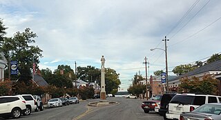
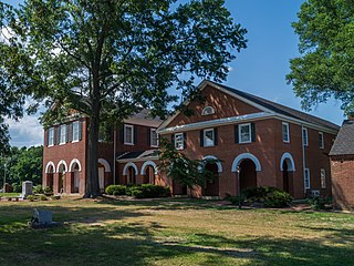
Tappahannock is the oldest town in Essex County, Virginia, United States. The population was 2,375 at the 2010 census, up from 2,068 at the 2000 census. Located on the Rappahannock River, Tappahannock is the county seat of Essex County. Its name comes from an Algonquian language word lappihanne, meaning "Town on the rise and fall of water" or "where the tide ebbs and flows." The Rappahannock is a tidal estuary from above this point and downriver to its mouth on Chesapeake Bay.
Fort Hunt is a census-designated place (CDP) in Fairfax County, Virginia, United States. The area is named after Fort Hunt, which was built on the bank of the Potomac River in 1897 to defend Washington, D.C. from naval attack and is now a public park. The area is also notable for its high population of senior citizens and for being one of the first suburbs in wealthy Fairfax County. The population was 17,231 at the 2020 census.

Mount Vernon is a census-designated place (CDP) and unincorporated community in Fairfax County, Virginia, United States. The population was 12,914 at the 2020 census. Primarily due to its historical significance and natural recreation and beauty, the Mount Vernon area receives over one million tourists each year.

West Springfield is a census-designated place (CDP) in Fairfax County, Virginia, United States. The population was 23,369 at the 2020 census.

Irvington is a town on the Rappahannock River in Lancaster County, Virginia, United States. The population was 474 at the 2020 census. Located on a peninsula known as the Northern Neck, it has been designated a historic district.

The James River is a river in Virginia that begins in the Appalachian Mountains and flows from the confluence of the Cowpasture and Jackson Rivers in Botetourt County 348 miles (560 km) to the Chesapeake Bay. The river length extends to 444 miles (715 km) if the Jackson River is included, the longer of its two headwaters. It is the longest river in Virginia. Jamestown and Williamsburg, Virginia's first colonial capitals, and Richmond, Virginia's current capital, lie on the James River.

Tornado, also called Upper Falls, is a census-designated place (CDP) in Kanawha County, West Virginia, United States.

The Guyandotte River is a tributary of the Ohio River, approximately 166 mi (267 km) long, in southwestern West Virginia in the United States. It was named after the French term for the Wendat Native Americans. It drains an area of the unglaciated Allegheny Plateau south of the Ohio between the watersheds of the Kanawha River to the northeast and Twelvepole Creek and the Big Sandy River to the southwest. Via the Ohio River, it is part of the Mississippi River watershed.

The Tygart Valley River — also known as the Tygart River — is a principal tributary of the Monongahela River, approximately 135 miles (217 km) long, in east-central West Virginia in the United States. Via the Monongahela and Ohio rivers, it is part of the watershed of the Mississippi River, draining an area of 1,329 square miles (3,440 km2) in the Allegheny Mountains and the unglaciated portion of the Allegheny Plateau.
The Yeocomico River is a 1.1-mile-long (1.8 km) tidal tributary of the southern portion of the Potomac River in Virginia's Northern Neck. The Yeocomico forms the boundary between Westmoreland and Northumberland counties. Yeocomico is a Native American name roughly translated as "tossed to and fro by the waters." Others suggest it is an Algonquian word that means "four dwelling places" since the river has a branch on either side with each dividing into two large forks.
Pope's Creek is a 5.3-mile-long (8.5 km) tidal tributary of the Potomac River in Westmoreland County, Virginia. The George Washington Birthplace National Monument lies along the north side of Popes Creek. Popes Creek landing is located at 38°11′29″N76°54′16″W.
Eltham is a small unincorporated community in New Kent County, Virginia, United States. Located along state routes 30, 33, and 249 in modern times, it is slightly west of the town of West Point. It was named for the Eltham slave plantation, across from West Point on the nearby Pamunkey River.

Branciforte Creek is a 5.8-mile (9.3 km) long watercourse in Santa Cruz County, California, United States. Branciforte Creek rises on the western slopes of the Santa Cruz Mountains and discharges to the San Lorenzo River, which in turn empties into the Pacific Ocean. Within the State of California Branciforte Creek is classified within the Central Coast Basin. As of the year 2002, the State of California has designated Branciforte Creek as impaired with respect to turbidity and pathogens. The Branciforte watershed consists of 6,231 acres (25.22 km2), approximately 70 percent of which is covered with mixed evergreen forest, conifer forest and other undisturbed habitats.

Little Hunting Creek is a 3.6-mile-long (5.8 km) primarily tidal tributary of the Potomac River located in Fairfax County, Virginia, not to be confused with Hunting Creek farther north. A stone-arch bridge, completed in 1931, carries traffic on the George Washington Memorial Parkway across the narrow mouth of the creek, located 96.6 miles (155.5 km) upriver from the mouth of the Potomac. The Washington family built its Mount Vernon plantation on the Potomac River along both banks of Little Hunting Creek during colonial times. The creek is bordered by residential communities in addition to the Mount Vernon property. It is a popular location for recreational fishing, and much of the wildlife characteristic of the tidal Potomac wetlands can be spotted there.
Mattox Creek is a tributary of the Potomac River in the Washington District of Westmoreland County, Virginia, near the colonial stagecoach stop of Oak Grove. The creek is 13.9 miles (22.4 km) long, and the lower 3 miles (5 km) of the creek is navigable. It lies between, and only minutes from, the birthplaces of George Washington and James Monroe.

Big Run is a river of 13 miles in length, located one-and-a-half miles west of Spruce Knob in Monongahela National Forest, in Pendleton County, West Virginia. It is a tributary of the North Fork South Branch Potomac River.
38°01′20″N76°55′30″W / 38.0222°N 76.9250°W