
Ocean City, officially the Town of Ocean City, is an Atlantic resort town in Worcester County, Maryland, along the East Coast of the United States. The population was 6,844 at the 2020 U.S. census, although during summer weekends the city hosts between 320,000 and 345,000 vacationers and up to eight million visitors annually. During the summer, Ocean City becomes the second most populated municipality in Maryland, after Baltimore. It is part of the Salisbury metropolitan area, as defined by the United States Census Bureau.

Ocean City is a city in Cape May County, in the U.S. state of New Jersey. It is the principal city of the Ocean City metropolitan statistical area, which encompasses all of Cape May County, and is part of the Philadelphia-Wilmington-Camden, PA-NJ-DE-MD combined statistical area, also known as the Delaware Valley or Philadelphia metropolitan area. It is part of the South Jersey region of the state.

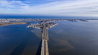
Long Beach is an oceanfront city in Nassau County in New York, United States. It takes up a central section of the Long Beach Barrier Island, which is the westernmost of the outer barrier islands off Long Island's South Shore. As of the 2020 Census, the city's population was 35,029, up from the 2019 estimate of 33,454. It was incorporated in 1922, and is nicknamed "The City by the Sea". The Long Beach Barrier Island is surrounded by Reynolds Channel to the north, east and west, and the Atlantic Ocean to the south.

Cherry Grove is a hamlet in the Town of Brookhaven, Suffolk County, New York, United States. It is located on Fire Island, a barrier island separated from the southern side of Long Island by the Great South Bay. The hamlet has approximately 300 houses on 41 acres (170,000 m2), a summer seasonal population of 2,000 and a year-round population of 15.

The Jersey Shore is the coastal region of the U.S. state of New Jersey. Geographically, the term encompasses about 141 miles (227 km) of oceanfront bordering the Atlantic Ocean, from Perth Amboy in the north to Cape May Point in the south. The region includes Middlesex, Monmouth, Ocean, Atlantic, and Cape May counties, which are in the central and southern parts of the state. Located in the center of the Northeast Megalopolis, the northern half of the shore region is part of the New York metropolitan area, while the southern half of the shore region is part of the Philadelphia metropolitan area, also known as the Delaware Valley. The Jersey Shore hosts the highest concentration of oceanside boardwalks in the United States.

Jones Beach State Park is a state park in the U.S. state of New York. It is located in southern Nassau County on Jones Beach Island, a barrier island linked to Long Island by the Meadowbrook State Parkway, Wantagh State Parkway, and Ocean Parkway. The park was created during Robert Moses' administration as President of the Long Island State Park Commission as part of the development of parkways on Long Island.

The Virgin Islands National Park is an American national park preserving about 60% of the land area of Saint John in the United States Virgin Islands, as well as more than 5,500 acres of adjacent ocean, and nearly all of Hassel Island, just off the Charlotte Amalie, Saint Thomas harbor.

Long Beach Island is a barrier island and summer colony along the Atlantic Ocean coast of Ocean County, New Jersey, United States, on the Jersey Shore. Aligned north to south, the northern portion generally has more expensive low-density housing, whereas the southern portion possesses higher-density housing and considerable commercial development. Long Beach Island is 1-2 miles away from Mainland New Jersey. The primary industries include tourism, fishing, and real estate. The only access point to the island by land is a single causeway.

The Santa Cruz Beach Boardwalk is an oceanfront amusement park in Santa Cruz, California. Founded in 1907, it is California's oldest surviving amusement park and one of the few seaside parks on the West Coast of the United States.

South Beach is a neighborhood on the East Shore of Staten Island, New York City, situated directly south of the Verrazzano-Narrows Bridge. South Beach is bounded by New York Bay on the southeast, Seaview Avenue on the southwest, Laconia Avenue on the northwest, Reid and McClean Avenues on the north, and Lily Pond Avenue on the northeast. It is adjacent to Midland Beach to the southwest, Dongan Hills and Old Town/Concord to the northwest, and Fort Wadsworth and Rosebank to the northeast.

The 1856 Last Island hurricane was a deadly and destructive tropical cyclone that is tied with 2020's Hurricane Laura and 2021's Hurricane Ida as the strongest hurricane on record to make landfall in the U.S. state of Louisiana, as measured by maximum sustained winds. The first known tropical cyclone of 1856 Atlantic hurricane season, it was observed first as a minimal hurricane in the Gulf of Mexico near Dry Tortugas on August 9. Moving northwestward, the cyclone quickly intensified into a strong Category 4 hurricane on the modern-day Saffir–Simpson scale by the following day. Late on August 10, the hurricane made landfall on Last Island, Louisiana, with winds at 150 mph (240 km/h), hours before striking near New Iberia. The system rapidly weakened after moving inland, falling to tropical storm intensity on August 11. The storm would be last noted over Mississippi on the next day.

Hog Island was the name of two islands near Long Island, New York until the 1890s. One is the present day Barnum Island, which includes the villages of Island Park and Harbor Isle in Nassau County. The other was a mile-long (1600 m) barrier island that existed to the south of Rockaway Beach in Queens before being mostly destroyed by the 1893 New York hurricane and completely lost to erosion and storm damage by 1902.
The Barnegat Peninsula, also known as the Island Beach Peninsula or Barnegat Bay Island and colloquially as "the barrier island", is a 20-mile (32 km) long, narrow barrier peninsula located on the Jersey Shore in Ocean County, New Jersey, United States, that divides the Barnegat Bay from the Atlantic Ocean. It is a vacation destination and summer colony area and is heavily dependent on tourism, real estate and fishing.

Pleasure Island is a coastal barrier island in Southeastern North Carolina, United States, just south of the City of Wilmington. Pleasure Island is located within Federal Point Township, in New Hanover County. The coastal resort towns of Carolina Beach and Kure Beach, as well as the annexed communities of Wilmington Beach and Hanby Beach are located on the island. The southern end of Pleasure Island was separated from Bald Head Island by Corncake Inlet until the inlet was shoaled and closed in 1998 by Hurricane Bonnie; thus Pleasure Island and Bald Head Island are no longer separate islands.

The Riegelmann Boardwalk is a 2.7-mile-long (4.3 km) boardwalk along the southern shore of the Coney Island peninsula in the New York City borough of Brooklyn, facing the Atlantic Ocean. Opened in 1923, the boardwalk runs between West 37th Street at the edge of the Sea Gate neighborhood to the west and Brighton 15th Street in Brighton Beach to the east. It is operated by the New York City Department of Parks and Recreation.

The South Beach–Franklin Delano Roosevelt Boardwalk, alternately referred to as the FDR Boardwalk or the South Beach Boardwalk, is a boardwalk facing the Lower New York Bay on the East Shore of Staten Island, one of the five boroughs of New York City. The boardwalk is the main feature of a public park that stretches from Fort Wadsworth and the Verrazzano-Narrows Bridge to Miller Field, both part of the Gateway National Recreation Area. The park also contains numerous recreational facilities, including a skate park.

Father Capodanno Boulevard, formerly Seaside Boulevard, is the primary north-south artery that runs through the Arrochar, South Beach, Ocean Breeze, Midland Beach, and New Dorp Beach neighborhoods of the New York City borough of Staten Island. The boulevard runs parallel to the South Beach Boardwalk and its public park.

The Rockaway Beach and Boardwalk is a public park in Rockaway, Queens, New York, composed of the 170-acre (69 ha) Rockaway Beach and the adjacent 5.5-mile (8.9 km) Rockaway Boardwalk. The beach runs from Beach 9th Street in Far Rockaway to Beach 149th Street in Neponsit, a distance of 7 miles (11 km). The boardwalk, a concrete deck, runs from Beach 9th Street to Beach 126th Street in Rockaway Park, at the edge of Belle Harbor. There are also numerous recreational facilities within the park, parallel to the beach and boardwalk.
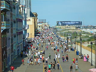
A boardwalk is a promenade along a beach or waterfront. In North America, and particularly in the United States, many waterfront commercial boardwalks in the United States have become so successful as tourist attractions that the simple wooden pathways have been replaced by esplanades made of concrete, brick or other construction, sometimes with a wooden façade on the surface. An entertainment boardwalk often contains an amusement park, casinos, or hotels on a pier-like structure. One of the earliest such boardwalks was designed in New Jersey and opened June 26, 1870, in Atlantic City.


