
The Peak District is an upland area in England at the southern end of the Pennines. Mostly in Derbyshire, it extends into Cheshire, Greater Manchester, Staffordshire, West Yorkshire and South Yorkshire. It includes the Dark Peak, where moorland is found and the geology is dominated by gritstone, and the White Peak, a limestone area with valleys and gorges. The Dark Peak forms an arc on the north, east and west sides; the White Peak covers central and southern tracts. The historic Peak District extends beyond the National Park, which excludes major towns, quarries and industrial areas. It became the first of the national parks of England and Wales in 1951. Nearby Manchester, Stoke-on-Trent, Derby and Sheffield send millions of visitors – some 20 million live within an hour's ride. Inhabited from the Mesolithic era, it shows evidence of the Neolithic, Bronze and Iron Ages. Settled by the Romans and Anglo-Saxons, it remained largely agricultural; mining arose in the Middle Ages. Richard Arkwright built cotton mills in the Industrial Revolution. As mining declined, quarrying grew. Tourism came with the railways, spurred by the landscape, spa towns and Castleton's show caves.

Castleton is a village in the High Peak district of Derbyshire, England, at the western end of the Hope Valley on the Peakshole Water, a tributary of the River Noe, between the Dark Peak to the north and the White Peak to the south. The population was 642 at the 2011 Census.

High Peak is a local government district with borough status in Derbyshire, England. The borough compromises high moorland plateau in the Dark Peak area of the Peak District National Park. The district stretches from Holme Moss in the north to Sterndale Moor in the south, and from Hague Bar in the west to Bamford in the east. The population of the borough taken at the 2011 Census was 90,892. The borough is unusual in having two administrative centres for its council, High Peak Borough Council; the offices are based in both Buxton and Glossop. The borough also contains other towns including Chapel-en-le-Frith, Hadfield, New Mills and Whaley Bridge.

The Peak Cavern, also known as the Devil's Arse, is one of the four show caves in Castleton, Derbyshire, England. Peakshole Water flows through and out of the cave, which has the largest cave entrance in Britain.

The White Peak, also known as the Low Peak, is a limestone plateau that forms the central and southern part of the Peak District in England. It is mostly between 270 metres (900 ft) and 430 metres (1,400 ft) above sea-level and is enclosed by the higher altitude Dark Peak to the west, north and east.

The Hope Valley is a rural area centred on the village of Hope, Derbyshire, in the Peak District in the northern Midlands of England.

High Peak is a parliamentary constituency represented in the House of Commons of the UK Parliament since 2019 by Robert Largan, a Conservative.

Hope railway station serves the villages of Hope and Brough in the Derbyshire Peak District of England, 14+3⁄4 miles (23.7 km) west of Sheffield.

Treak Cliff Cavern is a show cave near Castleton in Derbyshire, England. It is part of the Castleton Site of Special Scientific Interest and one of only two sites where the ornamental mineral Blue John is still excavated. As part of an agreement with English Nature, the Blue John that can be seen in the show cave is not mined but it is extracted in small quantities from other areas of the cave and made into saleable items like bowls, jewellery, and ornaments.
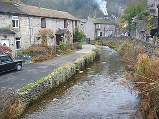
Peakshole Water is a stream in the Derbyshire Peak District named after its source, Peak Cavern. It flows through the village of Castleton to join the River Noe in nearby Hope. Despite its name, much of its flow actually emerges from the Russet Well, a resurgence in a garden on the east side of the gorge below the main Peak Cavern entrance, described as the "main resurgence of the Castleton area", which drains a series of swallets on the other side of the Pennine watershed below Rushup Edge. The resurgence has been explored by cave divers to a depth of 82 feet (25 m) but further exploration was halted by a constriction.
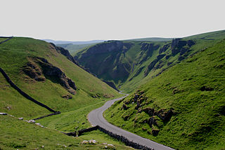
Winnats Pass is a hill pass and limestone gorge in the Peak District of Derbyshire, England. The name is a corruption of 'wind gates' due to the swirling winds through the pass. It lies west of the village of Castleton, in the National Trust's High Peak Estate and the High Peak borough of Derbyshire. The road winds through a cleft, surrounded by high limestone ridges. At the foot of the pass is the entrance to Speedwell Cavern, a karst cave accessed through a flooded lead mine, and which is a popular tourist attraction.

The A625 is a rural road which runs through north Derbyshire and the Peak District in England.
Titan is a natural cavern near Castleton in the Derbyshire Peak District, and is the deepest shaft of any known cave in Britain, at 141.5 metres (464 ft). The existence of Titan was revealed in November 2006, following its discovery on 1 January 1999 after cavers discovered connections from the James Hall Over Engine Mine to both Speedwell Cavern and Peak Cavern. Previously, the deepest known underground shaft in Britain had been Gaping Gill on the slopes of Ingleborough in the Yorkshire Dales.

Odin Mine is a disused lead mine in the Peak District National Park, situated at grid reference SK133835. It lies on a site of 25 hectares near the village of Castleton, England. It is the oldest documented mine in Derbyshire and is thought to be one of the oldest lead mines in England. The mine is a Scheduled Ancient Monument and has biological and geological significance within the Castleton Site of Special Scientific Interest.

Eldon Hill is a hill in the Peak District National Park in the county of Derbyshire, England, 4 kilometres (2.5 mi) southwest of the village of Castleton. It is a 470-metre (1,540 ft) limestone hill whose pastureland is used for rough grazing, although a large proportion has been lost to limestone quarrying. It lies within the Castleton Site of Special Scientific Interest. Eldon Hill was formed when a bed of pure limestone was squeezed and upfolded by geological forces to form a dome; it is the highest limestone hill north of the River Wye.
Rushup Edge is a ridge in the Derbyshire Peak District of England. The ridge's highest point is Lord's Seat at 550 m (1,804 ft), while Mam Tor lies beyond its eastern end, at the western end of the Great Ridge.

Giant's Hole is a well-known cave near Castleton in Derbyshire, consisting mostly of large passages. It is a stream-way cave, and part of the Karst topography of the area.

The Forest of High Peak was, in medieval times, a moorland forest covering most of the north west of Derbyshire, England, extending as far south as Tideswell and Buxton. From the time of the Norman Conquest it was established as a royal hunting reserve, administered by William Peverel, a follower of William I, who was based at Peveril Castle. The Royal Forest of Peak was bounded by the River Goyt to the west, the River Wye to the south, the River Derwent to the east and the River Etherow to the north. In 1305 it covered about 100 square miles.

Hollins Cross lies between Mam Tor and Lose Hill on the Great Ridge that separates Castleton and Edale in Derbyshire, England.
