Related Research Articles

In antiquity, Paeonia or Paionia was the land and kingdom of the Paeonians or Paionians.

Mount Oeta is a mountain in Central Greece. A southeastern offshoot of the Pindus range, it is 2,152 m (7,060 ft) high. Since 1966, the core area of the mountain is a national park, and much of the rest has been declared a special area under Natura 2000.
Doris is a small mountainous district in ancient Greece, bounded by Aetolia, southern Thessaly, the Ozolian Locris, and Phocis. It is the original homeland of the Dorian Greeks. It lies between Mounts Oeta and Parnassus, and consists of the valley of the river Pindus (Πίνδος), a tributary of the Cephissus, into which it flows not far from the sources of the latter. The Pindus is now called the Apostoliá. This valley is open towards Phocis; but it lies higher than the valley of the Cephissus, rising above the towns of Drymaea, Tithronium, and Amphicaea, which are the last towns in Phocis.
Heraclea (Herakleia) in Trachis, also called Heraclea Trachinia, was a colony founded by the Spartans in 426 BC, the sixth year of the Peloponnesian War. It was also a polis (city-state).

Ypati is a village and a former municipality in Phthiotis, central peninsular Greece. Since the 2011 local government reform it is part of the municipality of Lamia, of which it is a municipal unit. The municipal unit has an area of 257.504 km2. In 2021 its population was 3,537 for the municipal unit, and 440 for the settlement of Ypati itself. The town has a long history, being founded at the turn of the 5th/4th century BC as the capital of the Aenianes. During the Roman period the town prospered and was regarded as the chief city of Thessaly, as well as a bishopric. It was probably abandoned in the 7th century as a result of the Slavic invasions, but was re-established by the 9th century as Neopatras. The town became prominent as a metropolitan see and was the capital of the Greek principality of Thessaly in 1268–1318 and of the Catalan Duchy of Neopatras from 1319 to 1391. It was conquered by the Ottomans in the early 15th century and remained under Ottoman rule until the Greek War of Independence.

Opuntian Locris or Eastern Locris was an ancient Greek region inhabited by the eastern division of the Locrians, the so-called tribe of the Locri Epicnemidii or Locri Opuntii.
Dryopes or Dryopians were one of the aboriginal tribes of ancient Greece. According to Herodotus, their earliest abode is said to have been on Mount Oeta in Central Greece and its adjacent valleys, in the district called after them, Dryopis (Δρυοπίς). The Dorians settled in that part of their country which lay between Oeta and Mount Parnassus, and which was afterwards called Doris; but Dryopis originally extended as far north as the river Spercheios. The name of Dryopis was still applied to the latter district in the time of Strabo, who calls it a tetrapolis, like Doris.

The Oetaeans or Oitaians were a relatively small ancient Greek tribe living on and around Mount Oeta, in Central Greece.
Madytus or Madytos was a Greek city and port of ancient Thrace, located in the region of the Thracian Chersonesos, nearly opposite to Abydos.
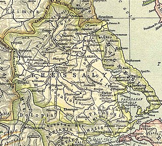
Histiaeotis or Hestiaeotis was a northwest district of ancient Thessaly, part of the Thessalian tetrarchy, roughly corresponding to the modern Trikala regional unit. Anciently, it was inhabited by the Hestiaeotae (Ἑστιαιῶται), and the Peneius may be described in general as its southern boundary. It occupied the passes of Mount Olympus, and extended westward as far as Pindus. The demonym of the district's inhabitants is Histiaeotes. In epigraphy, the regional name occurs as Hestiotai, ambassadors in Athens and Histiotai in the Thessalian grain decree for Rome but most similarly written names are related to Histiaea, an Attic deme and a city in North Euboea. The epigraphical Aeolic Greek vocalism of Hestiaeotis is bizarre and idiomatic.

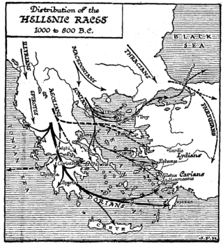
The regions of ancient Greece were sub-divisions of the Hellenic world as conceived by the Ancient Greeks of antiquity, shown by their presence in the works of ancient historians and geographers or in surviving legends and myths.
Ainis or Aeniania (Αἰνιανία), was a region of ancient Greece located near Lamia in modern Central Greece, roughly corresponding to the upper valley of the Spercheios river.
Canae was, in classical antiquity, a city in ancient Aeolis, on the island of Argennusa in the Aegean Sea off the modern Dikili Peninsula on the coast of modern-day Turkey, near the modern village of Bademli. Today Argennusa has joined the mainland as the Kane Promontory off the Dikili Peninsula. Canae is famous as the site of the Battle of Arginusae in 406 B.C.
Callium or Kallion, or Callipolis or Kallipolis (Καλλίπολις), was the chief town of the Callienses, situated on the eastern confines of ancient Aetolia, on one of the heights of Mount Oeta, and on the road from the valley of the Spercheus to Aetolia. It was by this road that the Gauls marched into Aetolia in 279 BCE, when they surprised and destroyed Callium, and committed the most horrible atrocities on the inhabitants. Callium also lay on the road from Pyra to Naupactus, and it was divided by Mount Corax from lower Aetolia.
Gonnus or Gonnos or Gonni (Γόννοι) was a town and polis (city-state) of the Perrhaebi in ancient Thessaly, which derived its name, according to the later Greek critics, from Gonneus, mentioned in the Iliad. Its position made it one of the most important places in the north of Thessaly. It stood on the northern side of the Peneius, near the entrance of the only two passes by which an enemy can penetrate into Thessaly from the north. The celebrated vale of Tempe begins to narrow at Gonnus; and the pass across Mount Olympus a little to the west of Tempe leads into Thessaly at Gonnus. It was by the latter route that the army of Xerxes I entered Thessaly.
Gyrton or Gyrtona or Gyrtone (Γυρτώνη) was a town and polis (city-state) of Perrhaebia in ancient Thessaly, situated in a fertile plain between the rivers Titaresius and Peneius. Strabo connects Gyrton with the mouth of the Peneius; but it is evident from the description of Livy, whose account has been derived from Polybius, that it stood in some part of those plains in which Phalanna, Atrax, and Larissa were situated. It was only one day's march from Phalanna to Gyrton. It was an ancient town even in Classical times, mentioned by Homer, and continued to be a place of importance till later times, when it is called opulent by Apollonius Rhodius. It was said to have been the original abode of the Phlegyae, and to have been founded by Gyrton, the brother of Phlegyas. Others say that it derived its name from Gyrtone, who is called a daughter of Phlegyas.
Meliboea or Meliboia was a town and polis (city-state) of Magnesia in ancient Thessaly, mentioned by Homer, in the Catalogue of Ships in the Iliad, as one of the places subject to Philoctetes. It was situated upon the sea coast, and is described by Livy as situated at the roots of Mount Ossa, and by Strabo as lying in the gulf between Mount Ossa and Mount Pelion.
Sperchiae or Sperchiai or Spercheiae or Spercheiai (Σπερχείαι) was a fortress in Ainis in ancient Thessaly, which, according to the description of Livy, would seem to have been situated at no great distance from the sources of the Spercheius. Ptolemy mentions a place Spercheia between Echinus and Thebes in Phthiotis; and Pliny the Elder places Sperchios in Doris. William Smith concludes it probable that these three names indicate the same place. Livy relates that the place was destroyed by the Aetolians in 198 BCE.
Macra Come or Makra Kome was a fortress mentioned by Livy along with Sperchiae in Ainis, in ancient Thessaly. It may have been a town of the Aenianes.
References
- ↑ Thucydides. History of the Peloponnesian War . Vol. 3.92-97, 8.3.
- ↑ Homer. Iliad . Vol. 2.749.
- ↑ Herodotus. Histories . Vol. 7.132.
- ↑ Pausanias (1918). "8.2". Description of Greece. Vol. 10. Translated by W. H. S. Jones; H. A. Ormerod. Cambridge, Massachusetts; London: Harvard University Press; William Heinemann – via Perseus Digital Library.
- ↑ Harpocrat. s.v. Ἀμφικτύονες
- ↑ Plut. Quaest. Gr. 13. p. 294; Strabo. Geographica . Vol. i. p.61, ix. p. 442. Page numbers refer to those of Isaac Casaubon 's edition.
- ↑ Livy. Ab urbe condita Libri [History of Rome]. Vol. 32.13.
- ↑ Ptolemy. The Geography . Vol. 3.13.45.
- ↑ Mogens Herman Hansen & Thomas Heine Nielsen (2004). "Thessaly and Adjacent Regions". An inventory of archaic and classical poleis . New York: Oxford University Press. pp. 684-685. ISBN 0-19-814099-1.
![]() This article incorporates text from a publication now in the public domain : Smith, William, ed. (1854–1857). "Thessalia". Dictionary of Greek and Roman Geography . London: John Murray.
This article incorporates text from a publication now in the public domain : Smith, William, ed. (1854–1857). "Thessalia". Dictionary of Greek and Roman Geography . London: John Murray.
| | This article about a location in ancient Thessaly is a stub. You can help Wikipedia by expanding it. |