Related Research Articles
Lechaeum or Lechaion, also called Lecheae and Lecheum, was the port in ancient Corinthia on the Corinthian Gulf connected with the city of Corinth by means of the Long Walls, 12 stadia in length. The Long Walls ran nearly due north, so that the wall on the right hand was called the eastern, and the one on the left hand the western or Sicyonian. The space between them must have been considerable; since there was sufficient space for an army to be drawn up for battle. Indeed, the area was the scene of battles between Sparta and Athens in 391 BCE, leaving Spartans in command of Lechaeum, which they garrisoned with their troops.
Asine was a town of ancient Laconia. According to Strabo, it was situated between Amathus and Gythium. It was often under Spartan control. Polybius relates that Philip V of Macedon, in his invasion of Laconia, suffered a repulse before Asine (218 BCE), which appears from his narrative to have been near Gythium. Pausanias, in describing the same event as Polybius, says that Philip was repulsed before "Las", which originally stood on the summit of "Mount Asia". There can therefore be no doubt that the "Las" of Pausanias and the "Asine" of Polybius are the same place; and the resemblance between the names "Asia" and "Asine" probably led Polybius into the error of calling Las by the latter name; an error which was the more likely to arise, because Herodotus and Thucydides speak of the Messenian Asine as a town in Laconia, since Messenia formed a part of Laconia at the time when they wrote. The error of Polybius was perpetuated by Strabo and Stephanus of Byzantium. During the Roman period Asine belonged to Sparta although most of the other towns in the area were part of the Union of Free Laconians.
Helos, also Hele (Ἕλη), was a town of ancient Laconia, situated east of the mouth of the Eurotas, close to the sea, in a plain which, though marshy near the coast, is described by Polybius as the most fertile part of Laconia. In the earliest times it appears to have been the chief town on the coast, as Amyclae was in the interior; for these two places are mentioned together by Homer in the Catalogue of Ships in the Iliad. Helos is said to have been founded by Heleius, the youngest son of Perseus. On its conquest by the Dorians its inhabitants were reduced to slavery; and, according to a common opinion in antiquity, their name became the general designation of the Spartan bondsmen, helots, but the name of these slaves (εἵλωτες) probably signified captives, and was derived from the root of ἑλεῖν. In the time of Strabo Helos was only a village; and when it was visited by Pausanias, it was in ruins. Helos is also mentioned by Thucydides, Xenophon, and Stephanus of Byzantium.
Thelpusa or Thelpousa, or Telphusa or Telphousa (Τέλφουσα), was a town in the west of ancient Arcadia, situated upon the left or eastern bank of the river Ladon. Its territory was bounded on the north by that of Psophis, on the south by that of Heraea, on the west by the Eleia and Tisatis, and on the east by that of Cleitor, Tripolis, and Theisoa. The town is said to have derived its name from a nymph, the daughter of the Ladon, which nymph was probably the stream flowing through the lower part of the town into the Ladon.
Caryae or Karyai was a town of ancient Laconia upon the frontiers of Arcadia. It was originally an Arcadian town belonging to Tegea, but was conquered by the Spartans and annexed to their territory. Caryae revolted from Sparta after the Battle of Leuctra (371 BCE), and offered to guide a Theban army into Laconia; but shortly afterwards it was severely punished for its treachery, for Archidamus III took the town and put to death all the inhabitants who were made prisoners.
Methydrium or Methydrion was a town in central ancient Arcadia, situated 170 stadia north of Megalopolis. It obtained its name, like the places called Interamna, from being situated upon a lofty height between the two rivers Maloetas and Mylaon. According to Greek mythology, it was founded by Orchomenus; but its inhabitants were removed to Megalopolis, upon the establishment of that city (371 BCE). It never recovered its former population, and is mentioned by Strabo among the places of Arcadia which had almost entirely disappeared. It continued, however, to exist as a village in the time of Pausanias, who saw there a temple of Poseidon Hippius upon the river Mylaon. He also mentions, above the river Maloetas, a mountain called Thaumasium, in which was a cave where Rhea took refuge when pregnant with Zeus. At the distance of 30 stadia from Methydrium was a fountain named Nymphasia. Methydrium is also mentioned by Thucydides, Xenophon,, Polybius, Pliny the Elder, and Stephanus of Byzantium.
Cardamyle or Kardamyle was a town of ancient Messenia. It is mentioned by Homer in the Iliad as one of the seven places offered by Agamemnon to Achilles. It was situated on a strong rocky height at the distance of seven stadia from the sea, and sixty from Leuctra. It is called a Laconian town by Herodotus, since the whole of Messenia was included in the territories of Laconia at the time of the historian. It again became a town of Messenia on the restoration of the independence of the latter; but it was finally separated from Messenia by Augustus, and annexed to Laconia. Pausanias mentions at Cardamyle sanctuaries of Athena and of Apollo Carneius; and in the neighbourhood of the town a temenos of the Nereids.
Geronthrae or Geronthrai, or Geranthrae or Geranthrai (Γεράνθραι), also written as Gerenthrae or Gerenthrai (Γερένθραι), was a town of ancient Laconia, situated in a commanding position upon the southwestern face of the mountain above the plain of the Eurotas. We learn from Pausanias that Geronthrae possessed a temple and grove of Ares, to whom a yearly festival was celebrated, from which women were excluded. Around the agora there were fountains of potable water. On the acropolis stood a temple of Apollo.
Phrixa or Phrixae or Phrixai (Φρίξαι) was a town of Triphylia in ancient Elis, situated upon the left bank of the Alpheius, at the distance of 30 stadia from Olympia. It is one of the six cities founded by the Minyans in the territory of the Paroreatae and Caucones. Its name was derived from Phaestus.
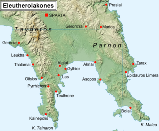
Thalamae or Thalamai was a town of ancient Laconia, which at various times belonged to Messenia.
Leuctra or Leuktra or Leuctrum or Leuktron was a town of Aegytis on the confines of Arcadia and Laconia, described by Thucydides as on the confines of Laconia toward Mount Lycaeus, and by Xenophon. It was originally an Arcadian town, but was included in the territory of Laconia. It commanded one of the passes leading into Laconia, by which a portion of the Theban army penetrated into the country on their first invasion under Epaminondas. It was detached from Sparta by Epaminondas, and added to the territory of Megalopolis. It appears to have stood on the direct road from Sparta to Megalopolis.
Oeantheia or Oiantheia or Oeanthe (Οἰάνθη) or Euanthis (Εὐανθίς) or Euanthia (Εὐανθία) was an important town of the Ozolian Locrians, situated at the western entrance of the Crissaean Gulf. Polybius says that it is opposite to Aegeira in Achaea. Thucydides relates that during the Peloponnesian War, the Oeanthians are among several towns of the Locri Ozolae that were forced to provide hostages to the Lacedaemonian army in 426 BCE. The Periplus of Pseudo-Scylax calls the town Euanthis; and since Strabo says that Locri Epizephyrii in Italy was founded by the Ozolian Locrians, under a leader named Euanthes, it has been conjectured that Oeantheia or Euantheia was the place where the emigrants embarked. Oeantheia appears to have been the only maritime city in Locris remaining in the time of Pausanias, with the exception of Naupactus. The only objects at Oeantheia mentioned by Pausanias were a temple of Aphrodite, and one of Artemis, situated in a grove above the town. The town is mentioned in the Tabula Peutingeriana as situated 20 miles (32 km) from Naupactus and 15 (24) from Anticyra.
Asea was a town of ancient Arcadia in the district Maenalia, situated near the frontier of Laconia, on the road from Megalopolis to Pallantium and Tegea. According to Greek mythology, Asea is said to be named for Aseatas, son of the Spartan king, Lycaon. During the Greco-Persian Wars, inhabitants of Asea fought in the historic Battle of Plataea (479 BCE). Asea took part in the foundation of Megalopolis, to which city most of its inhabitants removed in 371 BCE; but Asea continued to exist as an independent state, since the Aseatae are mentioned, along with the Megalopolitae, Tegeatae, and Pallantieis, as joining Epaminondas before the Battle of Mantineia in 362 BCE. At a later time, however, Asea belonged to Megalopolis, as we see from the descriptions of Strabo and Pausanias. The city was in ruins in the time of Pausanias, who mentions its acropolis. In its territory, and at the distance of 5 stadia from the city, on the road to Pallantium, were the sources of the Alpheius, and near them those of the Eurotas. The two rivers united their streams, and, after flowing in one channel for 20 stadia, disappeared beneath the earth; the Alpheius rising again at Pagae, and the Eurotas at Belemina in Laconia. North of Asea, on the road to Pallantium, and on the summit of Mount Boreium, was a temple of Athena Soteira and Poseidon, said to have been founded by Odysseus on his return from Troy. City coins have been found dated 196 BCE.
Eutaea or Eutaia was a town in the south of ancient Arcadia, in the district Maenalia, probably between Asea and Pallantium, though not on the road between these towns.
Sciritis or Skiritis was a rugged and barren mountainous district in the north of ancient Laconia, between the upper Eurotas on the west and the Oenus on the east, and extending north of the highest ridge of the mountains, which were the natural boundary between Laconia and Arcadia. The name probably expressed the wild and rugged nature of the country, for the word signified hard and rugged. It was bounded by Maenalia on the north, and by Parrhasia on the west, and was originally part of Arcadia, but was conquered at an early period, and its inhabitants reduced to the condition of Lacedaemonian Perioeci. According to Xenophon they were subjected to Sparta even before the time of Lycurgus.
Cromnus or Kromnos or Cromna or Kromna (Κρῶμνα), or Cromi or Kromoi (Κρῶμοι), was a town of ancient Arcadia on the frontiers of Messenia, the inhabitants of which were removed to Megalopolis, on the foundation of the latter city in 371 BCE. Its territory is called Cromitis or Kromitis (Κρωμῖτις) by Pausanias. Cromnus was the site of a battle where the Arcadians defeated the forces of Sparta under Archidamus III in 364 BCE.
Hypsus or Hypsous, also known as Hypsuntus or Hypsountos (Ὑψοῦντος), was a town of ancient Arcadia, in the district Cynuria, situated upon a mountain of the same name. According to Greek mythology, it was said to have been founded by Hypsus, a son of Lycaon.
Teuthrania was a town in the western part of ancient Mysia, and the name of its district about the river Caicus, which was believed to be derived from a legendary Mysian king Teuthras. This king is said to have adopted, as his son and successor, Telephus, a son of Heracles; and Eurypylus, the son of Telephus, appears in the Odyssey as the ruler of the Ceteii. The town was situated between Elaea, Pitane, and Atarneus. The nearby towns of Halisarna, Pergamum, and Teuthrania had been given by the Persian king Darius I to the Spartan king Demaratus about the year 486 BCE for his help in the expedition against Greece. Demaratus's descendants continued to rule these cities at the beginning of the 4th century BCE. During the withdrawal of Pergamum from The March of the Ten Thousand, it was attacked by, among others, troops from Halisarna and Teuthrania under command of Procles, son of Demaratus. In the Hellenica, Xenophon relates that Teuthrania, together with Pergamum, Halisarna, Gambrium, Palaegambrium, Myrina and Gryneium were delivered by their rulers to the army that, under the command of the Spartan Thimbron, around the year 399 BCE, had come to the area to try to liberate the Greek colonies from the Persian domain.
Dereium or Dereion, also known as Dera (Δέρα) and Derrhium or Derrhion (Δέρριον), was a town of ancient Laconia. Pausanias writes that it was on Taygetus not far from Lapithaeum, and 20 stadia from Harpleia. Dereium possessed an open image of Artemis Dereatis, and a spring called Anonus.
Sellasia, or Selasia (Σελασία), was a town of ancient Laconia, situated in the valley of the Oenus, on the road leading from Tegea and Argos, and one of the bulwarks of Sparta against an invading army. Its distance from Sparta is nowhere mentioned among the ancient writers; but from the description which Polybius gives of the celebrated battle fought in its neighbourhood between Antigonus III Doson and Cleomenes III in 222 BCE, it is probable that the plain now called Krevatá was the site of the battle. We learn from Polybius that this battle took place in a narrow opening of the vale of the Oenus, between two hills named Evas and Olympus, and that the river Gorgylus flowed across the plain into the Evenus.
References
- ↑ Xenophon. Hellenica . Vol. 6.5.24-26.
- ↑ Comp. Harpocrat. s. v. Οἶον.
- ↑ πολίχνιον Τεγέας. Αἰσχύλος Μυσοῖς: οἱ πολίται Οἰᾶται; Stephanus of Byzantium. Ethnica. Vol. s.v. Οἶος.
- ↑ Pausanias (1918). "13.7". Description of Greece. Vol. 7. Translated by W. H. S. Jones; H. A. Ormerod. Cambridge, Massachusetts; London: Harvard University Press; William Heinemann – via Perseus Digital Library.
- ↑ Suida s. v. Ἴασος.
- ↑ Richard Talbert, ed. (2000). Barrington Atlas of the Greek and Roman World . Princeton University Press. p. 58, and directory notes accompanying.
- ↑ Lund University. Digital Atlas of the Roman Empire.
![]() This article incorporates text from a publication now in the public domain : Smith, William, ed. (1854–1857). "Oeum". Dictionary of Greek and Roman Geography . London: John Murray.
This article incorporates text from a publication now in the public domain : Smith, William, ed. (1854–1857). "Oeum". Dictionary of Greek and Roman Geography . London: John Murray.
| Authority control databases: Geographic |
|---|
37°21′56″N22°23′43″E / 37.365486°N 22.395174°E
| | This article about a location in ancient Laconia is a stub. You can help Wikipedia by expanding it. |