Offenbach-Bieber

Last updated
Bieber
Offenbach-Bieber Luftbild 004.jpg
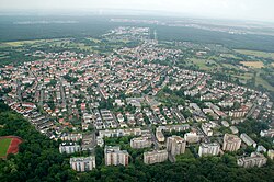
Aerial picture of Bieber from the west
WappenOffenbach-Bieber.png
Offenbach-Bieber
Location of Bieber
Germany adm location map.svg
Red pog.svg
Bieber
Hesse location map.svg
Red pog.svg
Bieber
Coordinates: 50°05′N08°48′E / 50.083°N 8.800°E / 50.083; 8.800
Country Germany
State Hesse
Admin. region Darmstadt
District Urban district
Town Offenbach am Main
Population
 (2020-12-31) [1]
  Total
16,137
Time zone UTC+01:00 (CET)
  Summer (DST) UTC+02:00 (CEST)
Postal codes
63073
Dialling codes 069
Bieberer Amulett Bieberer Amulett.JPG
Bieberer Amulett
Historical half-timbered building BieberFachwerk01.jpg
Historical half-timbered building

Bieber is a village in Hesse, Germany, with a total population of 16,137 as of 2020. [1] Since 1938 it has been a Stadtteil of Offenbach am Main.

Contents

Geography

A small river, a tributary of the Rodau called Bieber flows through the village.

At the top of the hill Bieberer Berg (elevation 120 m above NHN) stands the soccer-stadium Sparda Bank Hessen Stadion , formerly the Stadion Bieberer Berg , home of the soccer team Kickers Offenbach .

History

The village's name is derived from the Celtic people. Bieber as such was first mentioned in 791 as Biberaha in a donation.

Into the 19th century, Bieber's population was Roman Catholic. Now there is the catholic parish St. Nikolaus and a Protestant parish.

In 1938, the former municipality Bieber was merged with Offenbach.

Infrastructure

Transport

Bieber is part of the S-Bahn Rhein-Main-System with two S-Bahn stations: Offenbach-Bieber station is near the centre of the village and the other is in the borough of Bieber-Waldhof (3,500 Inhabitants in 2005).

References

  1. 1 2 "2020-Einwohnerstruktur nach Stadtteilen deutsch/nichtdeutsch" (PDF). Stadtverwaltung Offenbach. Retrieved 24 September 2021.