
The Stickeen Territories, also colloquially rendered as Stickeen Territory,Stikine Territory, and Stikeen Territory, was a territory of British North America whose brief existence began July 19, 1862, and concluded July of the following year. The region was split from the North-Western Territory in the wake of the Stikine Gold Rush. The initial strike attracted large numbers of miners — mostly American — to the region; by detaching the region from the exclusive trade zone of the Hudson's Bay Company, British authorities were able to impose tariffs and licences on the speculators. The new territory, named after the Stikine River, was under the responsibility of the Governor of the Colony of British Columbia, James Douglas, who was appointed "Administrator of the Stickeen Territories" and under British law, within the jurisdiction of the Supreme Court of British Columbia.

Carway is a hamlet in southern Alberta, Canada within Cardston County. It is a port of entry into the U.S. state of Montana opposite of Port of Piegan. Just on the other side of the border is the Blackfeet Indian Reservation in Glacier County, Montana.

Ultzama is a municipality located in the province and autonomous community of Navarre, northern Spain. Ultzama is also the name of the river from which the valley takes its name. It is located 22 km North of Pamplona, the capital city of Navarre.
Coldwater River Provincial Park is a provincial park in British Columbia, Canada, located at the confluence of the Coldwater River with Cullet Creek, 50 km south of Merritt on BC Highway 5.
Garden Bay Marine Provincial Park is a provincial park in British Columbia, Canada at the northwest end of the Sechelt Peninsula on the lower Sunshine Coast, near the community of Madeira Park. Established in 1969, it contains approximately 163 ha.
Okeover Arm Provincial Park is a provincial park in British Columbia, Canada, located on the west side of Okeover Inlet facing Desolation Sound, on the east side of the Malaspina Peninsula.
Stuart River Provincial Park is a provincial park in British Columbia, Canada. It is located in two sections north and northwest of Vanderhoofalong the Stuart River southeast of Stuart Lake and the city of Fort St. James. The upper section is located at 54°13′20″N124°00′00″W and comprises c.7391 ha. while the lower, eastern section is centred at 54°03′00″N123°37′00″W and comprises c.3390 ha. and is within the Greater Prince George area. The upper site, which is located around the confluence of the Stuart and Nechako Rivers, includes the site of Chinlac, a Dakelh village whose inhabitants were massacred and enslaved by the Tsilhqot'in of Anahim Lake c. 1745.
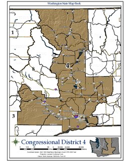
Washington's 4th congressional district encompasses a large area of central Washington, covering the counties of Douglas, Okanogan, Grant, Yakima, Franklin, Benton, and Adams, and part of Walla Walla County. The district is dominated by the Yakima and Tri-Cities areas. The Fourth District is predominantly rural, and is considerably more conservative than the western part of the state: it is in fact the most Republican district in the Pacific States.
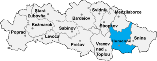
Kamienka is a village and municipality in Humenné District in the Prešov Region of north-east Slovakia.
The High Bar First Nation is a First Nations government of the Secwepemc (Shuswap) Nation, located in the Fraser Canyon-Cariboo region of the Central Interior of the Canadian province of British Columbia. It was created when the government of the then-Colony of British Columbia established an Indian Reserve system in the 1860s. It is one of three Secwepemc bands that is not a member of either the Shuswap Nation Tribal Council or the Northern Shuswap Tribal Council. The High Bar people are also partly Tsilhqot'in and have links with some Chilcotin First Nations.
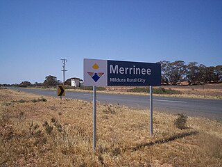
Merrinee is a locality situated in the Sunraysia region. It is situated about 7 kilometres west of Pirlta and 11 kilometres east of Karawinna, on the Red Cliffs-Meringur Road.

Zhylyoi District is a district located in the south-eastern region of Atyrau Region in Kazakhstan. The administrative center of the district is the town of Kulsary. Population: 75,377 ; 70,156 ; 57,052.

Mojżeszów is a village in the administrative district of Gmina Przedbórz, within Radomsko County, Łódź Voivodeship, in central Poland. It lies approximately 12 kilometres (7 mi) south-east of Przedbórz, 40 km (25 mi) east of Radomsko, and 94 km (58 mi) south-east of the regional capital Łódź.
M'Clure Bay is a Peel Sound waterway in Qikiqtaaluk Region, Nunavut, Canada. It is located on the western side of Somerset Island, between Aston Bay and Birmingham Bay.

Fimbulheimen is a mountain range in Queen Maud Land, Antarctica. It stretches from Jutulstraumen by 1° west of Carsten Borchgrevink Ice at 18° east, about 200 km from the ice edge. Fimbulheimen is thus between Maudheim Plateau and Sør-Rondane.

Chromosome 16 open reading frame 58, or C16orf58, also known as FLJ13638 is a protein which in humans is encoded by the C16orf58 gene. The gene itself is 18892 bp long, with mRNA of 2760 bp, and a protein sequence of 468 amino acids. There is a conserved domain of unknown, DUF647. No function has been determined for this gene yet, but it is predicted that it resides in the endoplasmic reticulum in the cytoplasm.

The Rocky Mountain Foothills are an upland area flanking the eastern side of the Rocky Mountains, extending south from the Liard River into Alberta. Bordering the Interior Plains system, they are part of the Rocky Mountain System or Eastern System of the Western Cordillera of North America.

Kunovo is a village in the municipality of Foča, Republika Srpska, Bosnia and Herzegovina.
Anoritooq is a nunatak in the Qaasuitsup municipality in northwestern Greenland.
Beni Semiel is a town and commune in Tlemcen Province in northwestern Algeria.

