Ohio State Route 140

Last updated

OH-140.svg

State Route 140
OH 140 map.svg
Route information
Maintained by ODOT
Length20.74 mi [1] (33.38 km)
Existed1923 [2] [3] –present
Major junctions
West endUS 52.svg US 52 in Portsmouth
East endOH-93.svg SR 93 near Oak Hill
Location
Counties Scioto, Lawrence, Jackson
Highway system
OH-139.svg SR 139 SR 141 OH-141.svg
A view of SR 140 entering South Webster from the northeast OHSR140SouthWebster.JPG
A view of SR 140 entering South Webster from the northeast
A view of SR 140 entering Scioto Furnace from the northeast OHSR140SciotoFurnace.JPG
A view of SR 140 entering Scioto Furnace from the northeast

State Route 140 (SR 140) is an eastwest state highway in the southern portion of the U.S. state of Ohio. The highway has its western terminus in Portsmouth at a diamond interchange with U.S. Route 52. Its eastern terminus is at State Route 93 approximately 2.75 miles (4.43 km) south of Oak Hill.

A state highway, state road, or state route is usually a road that is either numbered or maintained by a sub-national state or province. A road numbered by a state or province falls below numbered national highways in the hierarchy. Roads maintained by a state or province include both nationally numbered highways and un-numbered state highways. Depending on the state, "state highway" may be used for one meaning and "state road" or "state route" for the other.

U.S. state constituent political entity of the United States

In the United States, a state is a constituent political entity, of which there are currently 50. Bound together in a political union, each state holds governmental jurisdiction over a separate and defined geographic territory and shares its sovereignty with the federal government. Due to this shared sovereignty, Americans are citizens both of the federal republic and of the state in which they reside. State citizenship and residency are flexible, and no government approval is required to move between states, except for persons restricted by certain types of court orders. Four states use the term commonwealth rather than state in their full official names.

Ohio State of the United States of America

Ohio is a Midwestern state in the Great Lakes region of the United States. Of the fifty states, it is the 34th largest by area, the seventh most populous, and the tenth most densely populated. The state's capital and largest city is Columbus.

Contents

State Route 140 first appeared in the mid-1920s. The two-lane highway passes through three counties along its path: Scioto, Lawrence and Jackson. It begins at an interchange with U.S. Route 52 and, immediately following the interchange, leaves the Portsmouth corporation limits and heads east. The route makes a quick hilly climb upward and downward to the former Teays River Valley near Slocum; it then traverses primarily wooded areas as it passes through Ashley Corner, Scioto Furnace, South Webster, and Eifort. It retains the forested area up until its eastern terminus. For most of its alignment, State Route 140 parallels an abandoned Baltimore and Ohio Railroad line.

Scioto County, Ohio County in the United States

Scioto County is a county located along the Ohio River in the south central region of the U.S. state of Ohio. As of the 2010 census, the population was 79,499. Its county seat is Portsmouth. The county was founded March 24, 1803 from Adams County and is named for an Indian word referring to deer or deer-hunting.

Lawrence County, Ohio County in the United States

Lawrence County is the southernmost county located in the U.S. state of Ohio. As of the 2010 census, the population was 62,450. Its county seat is Ironton. The county was created in 1815 and later organized in 1817. It is named for James Lawrence, the naval officer famous for the line "do not give up the ship".

Jackson County, Ohio County in the United States

Jackson County is a county located in the U.S. state of Ohio. As of the 2010 census, the population was 33,225. Its county seat is Jackson. The county is named for Andrew Jackson, a hero of the War of 1812 who was subsequently elected President of the United States. It is known as "The Little Wales of Ohio."

Route description

Along its way, State Route 140 travels through eastern Scioto County, clips the northwestern corner of Lawrence County and then sneaks into southern Jackson County. State Route 140 is not a part of the National Highway System, a system of highways deemed most important for the nation's economy, mobility and defense. [4]

National Highway System (United States) highway system in the United States

The National Highway System (NHS) is a network of strategic highways within the United States, including the Interstate Highway System and other roads serving major airports, ports, rail or truck terminals, railway stations, pipeline terminals and other strategic transport facilities. Altogether, it constitutes the largest highway system in the world.

History

State Route 140 was established in 1923. The original routing of the highway is the one which it still utilizes to this day through Scioto, Lawrence and Jackson Counties. The highway has not experienced any major changes since its inception, excepting the highways that it intersects at its endpoints. Its western terminus, which is now U.S. Route 52, was originally a part of State Route 7. Meanwhile, its eastern terminus, which is currently State Route 93, was originally designated as State Route 75. [2] [3]

State Route 7 (SR 7), formerly known as Inter-county Highway 7 until 1921 and State Highway 7 in 1922, is a north–south state highway in the southern and eastern portions of the U.S. state of Ohio. At just over 337 miles (542 km) in length, it is the longest state route in Ohio. Its southern terminus is an interchange with U.S. Route 52 (US 52) just west of Chesapeake. Its northern terminus also serves as the eastern terminus of SR 531 in Conneaut. The path of SR 7 stays within five miles (8.0 km) of the Ohio River for the southern portion, with the river being visible from much of the route. The road also remains within 10 miles (16 km) of the Pennsylvania state line for the northern portion.

Ohio State Route 93 highway in Ohio

State Route 93 is a north–south highway that stretches from Ironton on the Oakley C. Collins Memorial Bridge to State Route 261 in Akron. At a length of 234 miles (377 km), it is the third longest state route in Ohio. The route from Ironton to West Lafayette was once signed as State Route 75. In 1962, to eliminate confusion with an interstate in Ohio having the same number, State Route 75 was replaced by State Route 93 which had previously terminated in West Lafayette.

Major intersections

CountyLocationmi [1] kmDestinationsNotes
Scioto Portsmouth 0.00–
0.18
0.00–
0.29
US 52.svg US 52 / Webster Street New Boston, Ironton Interchange
0.430.69OH-823.svg SR 823 (north) Chillicothe Interchange; northbound entrance only
Lawrence
No major junctions
Jackson Jefferson Township 20.7433.38OH-93.svg SR 93  Oak Hill, Ironton
1.000 mi = 1.609 km; 1.000 km = 0.621 mi

Related Research Articles

Ohio State Route 253 highway in Ohio

State Route 253 is a very short east–west state highway in the southern part of the U.S. state of Ohio. With an overall length of just 0.56 miles (0.90 km), the majority of SR 253 is a part of the Jesse Stuart Memorial Bridge, which crosses over the Ohio River near Franklin Furnace, Ohio. The western terminus of SR 253 is at about the midspan of the bridge, where it crosses the Kentucky State Line and becomes Kentucky Route 10 (KY 10). The eastern terminus of the highway is at a diamond interchange with U.S. Route 52 (US 52) near the eastern landing of the Ohio River crossing. The current SR 253 was established in the late 1980s. However, an earlier version of the highway existed in the Medina vicinity from the early 1920s until the late 1950s.

Ohio State Route 139 highway in Ohio

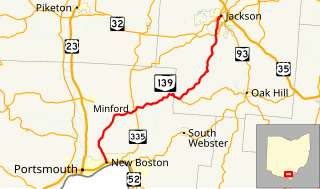
State Route 139 is a north–south road that stretches from New Boston at its southern terminus to Jackson, Ohio at its northern terminus. This route offers a quick, yet narrow and sharp route to Jackson. US 23 and SR 32 offer a more straight route with a higher speed limit, though less direct.

Ohio State Route 522 highway in Ohio

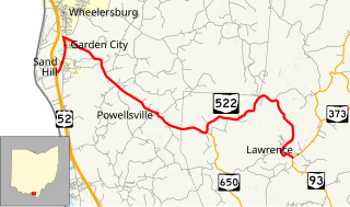
State Route 522 is an east–west state highway in the southern portion of the U.S. state of Ohio. State Route 522 has its western terminus is at a diamond interchange with U.S. Route 52 less than 3 miles (4.8 km) south of Wheelersburg. Its eastern terminus is at a T-intersection with State Route 93 just over 9 miles (14 km) north of Ironton.

Ohio State Route 166 highway in Ohio

State Route 166 is an east–west state highway in the northeastern portion of the U.S. state of Ohio. The western terminus of State Route 166 is at a T-intersection with U.S. Route 6 just over 3 miles (4.8 km) northeast of Chardon. Its western terminus is at State Route 534 about 5 miles (8.0 km) west of Rock Creek.

Ohio State Route 99 highway in Ohio

State Route 99 (SR 99) is a north–south state highway in the north-central portion of the U.S. state of Ohio. The highway's southern terminus is in the southern end of Willard at a T-intersection with U.S. Route 224 (US 224). Its northern terminus is at its junction with SR 4 about 6 miles (9.7 km) southwest of the city limits of Sandusky.

Ohio State Route 63 highway in Ohio

State Route 63 (SR 63) is a 11.74-mile (18.89 km) long east–west state highway located in the southwestern portion of the U.S. state of Ohio. The western terminus of SR 63 is at a trumpet interchange with SR 4 on the western outskirts of Monroe. Its eastern terminus is at a signalized intersection with US 42, SR 48 and SR 123 in downtown Lebanon.

Ohio State Route 96 highway in Ohio

State Route 96 is an east–west state highway in the northern portion of the U.S. state of Ohio. The southern terminus of SR 96 is at a T-intersection with SR 98 nearly 2 12 miles (4.0 km) northeast of Bucyrus. Its eastern terminus is at an interchange with US 42 and US 250 in the eastern portion of Ashland.

Ohio State Route 252 highway in Ohio

State Route 252 (SR 252) is a 23.04-mile (37.08 km) long north–south state highway in the northern portion of the U.S. state of Ohio. The southern terminus of this state route is at a signalized intersection that marks the western split of the concurrency of SR 18 and SR 57 nearly 1.25 miles (2.01 km) northwest of the city limits of Medina. SR 252 has its northern terminus at a T-intersection with U.S. Route 6 (US 6) in the western Cleveland suburb of Bay Village.

Ohio State Route 257 highway in Ohio

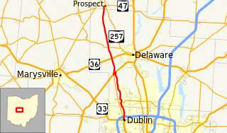
State Route 257 is a 26.19-mile (42.15 km) north - south state highway in the central portion of the U.S. state of Ohio. The highway's southern terminus is in the northwestern Columbus suburb of Dublin at a roundabout intersection with U.S. Route 33 and SR 161. This mainly two-lane highway follows the eastern side of the Scioto River from Dublin to its junction with US 42. After crossing over the river with the U.S. highway, SR 257 parallels the river's western bank. SR 257 has its northern terminus at a T-intersection with SR 47 on the western village limits of Prospect. SR 257 was created in 1926, and extended in 1935 and 1937.

Ohio State Route 180 highway in Ohio

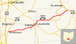
State Route 180 (SR 180) is a 29.55-mile (47.56 km) long east–west state highway in the southern portion of the U.S. state of Ohio. SR 180 has its western terminus at a T-intersection with SR 159 nearly 5 miles (8.0 km) northeast of Chillicothe. Its eastern terminus is at a diamond interchange with the U.S. Route 33 (US 33) expressway approximately 3.75 miles (6.04 km) northwest of Logan.

Ohio State Route 188 highway in Ohio

State Route 188 (SR 188) is a 39.04-mile-long (62.83 km) east–west state highway located in the central part of the U.S. state of Ohio. SR 188's western terminus is in Circleville at a signalized intersection where it meets the concurrency of U.S. Route 22 (US 22) and SR 56. Its eastern terminus is at a signalized intersection with SR 204 in the central business district of the village of Thornville.

Ohio State Route 116 highway in Ohio

State Route 116 is a north–south state highway in the western portion of the U.S. state of Ohio. The highway's southern terminus is at a signalized intersection with State Route 29, State Route 66, and the eastern terminus of State Route 703 in St. Marys. Its northern terminus is at another signalized intersection, this time with U.S. Route 127 in the southern end of Van Wert.

Ohio State Route 144 highway in Ohio

State Route 144 is a north–south state highway in the southern portion of Ohio, a U.S. state. The southern terminus of State Route 144 is at is a T-interchange with State Route 124 in Hockingport. Its northern terminus is at another T-intersection, this time with State Route 329 in the unincorporated community of Stewart.

Ohio State Route 209 highway in Ohio

State Route 209 is an east–west state highway in eastern Ohio, a U.S. state. The western terminus of State Route 209 is at a T-intersection with State Route 83 approximately 3.75 miles (6.04 km) north of New Concord. State Route 209's eastern terminus is concurrent with the northern terminus of State Route 821 at Interstate 77 at its exit 41 in Byesville, just 2.25 miles (3.62 km) southeast of the Interstate's interchange with Interstate 70.

Ohio State Route 215 highway in Ohio

State Route 215 is an east–west state highway in the southeastern portion of the U.S. state of Ohio. The western terminus of SR 215 is at a T-intersection with SR 821 just one-half mile (0.80 km) southeast of the village of Belle Valley and SR 821's junction with Interstate 77. Its eastern terminus is at another T-intersection, this time with SR 285 just outside the village of Sarahsville.

Ohio State Route 174 highway in Ohio

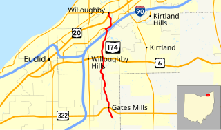
State Route 174 (SR 174) is a 9.56-mile (15.39 km) long north–south state highway in the northeastern quadrant of the U.S. state of Ohio. The highway runs from its southern terminus at a T-intersection with Old Mill Road in a quiet residential neighborhood in the eastern Cleveland suburb of Gates Mills to its northern terminus at a signalized intersection with U.S. Route 20 (US 20) in Willoughby that doubles as the eastern terminus of SR 640.

Ohio State Route 222 highway in Ohio

State Route 222 (SR 222) is a 29.14-mile-long (46.90 km) north–south state highway in the southwestern part of the U.S. state of Ohio. The southern terminus of SR 222 is at U.S. Route 52 (US 52) in the village of Chilo. Its northern terminus is at a signalized T-intersection with US 50 approximately 3.50 miles (5.63 km) northwest of Batavia.

State Route 182 was a 7.97-mile-long (12.83 km) east–west state highway in the northwestern part of the U.S. state of Ohio. The route ran from Ohio State Route 231 in Nevada to SR 53, SR 67, and SR 199 in Upper Sandusky. It ran through the county of Wyandot.

Ohio State Route 145 highway in Ohio

State Route 145 is a 46.14-mile (74.26 km) long north–south state highway in the southeastern quadrant of the U.S. state of Ohio. The western terminus of SR 145 is at a T-intersection with SR 821 in Lower Salem. Its eastern terminus is at a T-intersection with SR 148 approximately 5.25 miles (8.45 km) northeast of Beallsville.

Ohio State Route 541

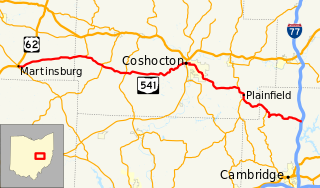
State Route 541 is a 52.28-mile-long (84.14 km) state highway in central Ohio. The route's western terminus is US 62 in Martinsburg and its eastern terminus is at exit 54 of I-77 in Liberty Township.

References

  1. 1 2 "Data Download - ODOT TIMS (Road Inventory shapefile)". Ohio Department of Transportation. Retrieved April 14, 2019.
  2. 1 2 Map of Ohio State Highways (MrSID) (Map). Cartography by ODHPW. Ohio Department of Highways and Public Works. April 1922. Retrieved 2011-01-10.
  3. 1 2 Map of Ohio Showing State Routes (MrSID) (Map). Cartography by ODHPW. Ohio Department of Highways and Public Works. July 1923. Retrieved 2011-01-10.
  4. National Highway System: Ohio (PDF) (Map). Federal Highway Administration. December 2003. Retrieved 2011-01-10.

Route map:

KML file (edithelp)
    KML is from Wikidata