State Route 330 is a north–south state highway in the northwestern portion of the U.S. state of Ohio. The southern terminus of SR 330 is at a diamond interchange with the SR 15 expressway just south of the village limits of Vanlue. Its northern terminus is at SR 568 nearly 1.75 miles (2.82 km) north of Vanlue.

State Route 53 is a north–south state highway in the U.S. state of Ohio. Its southern terminus is at the beginning of the U.S. 68/S.R. 67 concurrency in Kenton, Ohio, and its northern terminus is on Catawba Island in Ottawa County, north of Port Clinton.
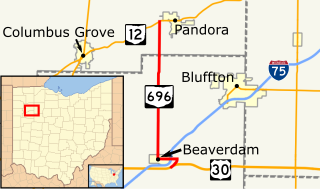
State Route 696 is a north–south state route in the western part of the U.S. state of Ohio. State Route 696's southern terminus is at an interchange with the U.S. Route 30 expressway about 1 mile (1.6 km) east of Beaverdam.
State Route 7 (SR 7), formerly known as Inter-county Highway 7 until 1921 and State Highway 7 in 1922, is a north–south state highway in the southern and eastern portions of the U.S. state of Ohio. At just over 337 miles (542 km) in length, it is the longest state route in Ohio. Its southern terminus is an interchange with U.S. Route 52 (US 52) just west of Chesapeake. Its northern terminus also serves as the eastern terminus of SR 531 in Conneaut. The path of SR 7 stays within five miles (8.0 km) of the Ohio River for the southern portion, with the river being visible from much of the route. The road also remains within 10 miles (16 km) of the Pennsylvania state line for the northern portion.

State Route 795 is an east–west state highway in northwestern Ohio, a U.S. state. The western terminus of SR 795 is at US 20 in Perrysburg, at the signalized intersection that doubles as the northern terminus of SR 199. Its eastern terminus is at a signalized intersection with SR 51 about 0.5 miles (0.80 km) southeast of Millbury.

State Route 253 is a very short east–west state highway in the southern part of the U.S. state of Ohio. With an overall length of just 0.56 miles (0.90 km), the majority of SR 253 is a part of the Jesse Stuart Memorial Bridge, which crosses over the Ohio River near Franklin Furnace, Ohio. The western terminus of SR 253 is at about the midspan of the bridge, where it crosses the Kentucky State Line and becomes Kentucky Route 10 (KY 10). The eastern terminus of the highway is at a diamond interchange with U.S. Route 52 (US 52) near the eastern landing of the Ohio River crossing. The current SR 253 was established in the late 1980s. However, an earlier version of the highway existed in the Medina vicinity from the early 1920s until the late 1950s.
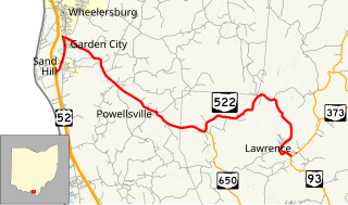
State Route 522 is an east–west state highway in the southern portion of the U.S. state of Ohio. State Route 522 has its western terminus is at a diamond interchange with U.S. Route 52 less than 3 miles (4.8 km) south of Wheelersburg. Its eastern terminus is at a T-intersection with State Route 93 just over 9 miles (14 km) north of Ironton.

State Route 638 is a two-lane north–south state highway in the west central portion of Ohio, a U.S. state. SR 638 has its southern terminus at an intersection with U.S. Route 68 (US 68) just over six miles (9.7 km) north of the city of Bellefontaine. The northern terminus of the route is at SR 273 at the extreme southeastern corner of the village of Belle Center.

State Route 287 (SR 287) is a 13.69-mile-long (22.03 km) east–west state highway in the western portion of the U.S. state of Ohio. The western terminus of SR 287 is at SR 245 nearly 1.75 miles (2.82 km) east of West Liberty. Its eastern terminus is at an interchange with U.S. Route 33 (US 33) about 5.25 miles (8.45 km) northeast of North Lewisburg that dually serves as the southern terminus of SR 739.
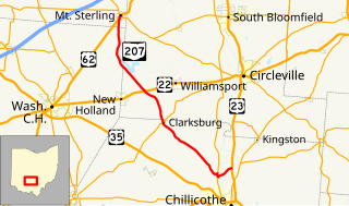
State Route 207 is a 31.23-mile (50.26 km) long north–south state highway in the southern portion of the U.S. state of Ohio. The southern terminus of SR 207 is at a diamond interchange with U.S. Route 23 (US 23) nearly 4 miles (6.4 km) north of Chillicothe. Its northern terminus is in Mount Sterling, following a 0.33-mile (0.53 km) long concurrenty with US 62 and SR 3, at the intersection where they meet SR 56.
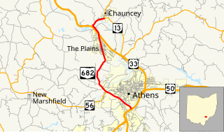
State Route 682 is a north–south state highway in the southeastern portion of the U.S. state of Ohio. The southern terminus of State Route 682 is at a trumpet interchange with US 33, US 50 and SR 32 in Athens. Its northern terminus is at SR 13 in the village of Chauncey, Ohio.

State Route 31 (SR 31) is a 32.12-mile-long (51.69 km) Ohio State Route that runs between Marysville and Kenton in the US state of Ohio. The southern terminus of SR 31 is at an intersection with SR 38 in downtown Marysville and the northern terminus is at an intersection with U.S. Route 68 (US 69), in downtown Kenton. None of the highway is listed on the National Highway System. Most of the route is a rural two-lane highway and passes through both farmland and residential properties.

State Route 274 is a two-lane east–west state highway located in the western portion of the U.S. state of Ohio. The western terminus of State Route 274 is at a T-intersection with U.S. Route 127 approximately 4 miles (6.4 km) west of Chickasaw. Its eastern terminus is at another T-intersection, this time with State Route 273 about 3.5 miles (5.6 km) northeast of Rushsylvania.

State Route 595 is a north–south state highway in southeastern Ohio, a U.S. state. The route's southern terminus is at a diamond interchange with the U.S. Route 33 (US 33) expressway approximately three and a half miles (5.6 km) southeast of Logan. Its northern terminus is at a T-intersection with SR 216 in New Straitsville, just two blocks southeast of SR 216's northern terminus at SR 93.

State Road 63 (SR 63) in the U.S. state of Indiana is a north–south route in the western portion of the state. Until mid-2008, it covered a distance of just over 96 miles (154 km), but now is a discontinuous route. For 63 miles (101 km), from the city of Terre Haute until it rejoins U.S. Route 41 (US 41) near Carbondale, it is a four-lane divided highway and replaces US 41 as the major north–south artery in this portion of the state.
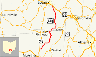
State Route 328 (SR 328) is a north–south state highway in the southeastern quadrant of the U.S. state of Ohio. The southern terminus of SR 328 is at SR 93 approximately 2.75 miles (4.43 km) north of McArthur. Its northern terminus is at a diamond interchange with U.S. Route 33 (US 33) in the extreme southeastern portion of Logan, immediately northeast of where it crosses over the Hocking River.

State Route 661 (SR 661) is a 22.22-mile (35.76 km) long north–south state highway in the central portion of the U.S. state of Ohio. The southern terminus of SR 661 is at a diamond interchange with SR 16 and SR 37 just 0.25 miles (0.40 km) south of Granville. SR 661 has its northern terminus at a signalized T-intersection with SR 13 in the southern end of Mount Vernon.
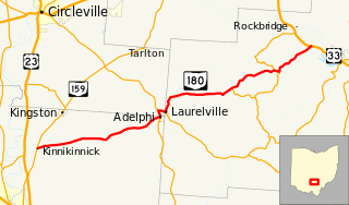
State Route 180 (SR 180) is a 29.55-mile (47.56 km) long east–west state highway in the southern portion of the U.S. state of Ohio. SR 180 has its western terminus at a T-intersection with SR 159 nearly 5 miles (8.0 km) northeast of Chillicothe. Its eastern terminus is at a diamond interchange with the U.S. Route 33 (US 33) expressway approximately 3.75 miles (6.04 km) northwest of Logan.
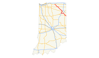
U.S. Route 33 (US 33) is part of the United States Numbered Highway System that runs from Richmond, Virginia to Elkhart of the US state of Indiana. In Indiana, it is a state road that enters the state at the Ohio state line between Willshire, Ohio, and Pleasant Mills, Indiana. The 106.217 miles (170.940 km) of US 33 that lie within Indiana serve as a major conduit. All of the highway is listed on the National Highway System. Various sections are rural two-lane highway, urbanized four-lane divided expressway and the Lincoln Highway. The northernmost community along the highway is Elkhart. The highway ends at an interchange in southern Elkhart after serving the northeastern region of Indiana. US 33 passes through farm fields and urban areas.