U.S. Route 224 (US 224) is a spur of US 24 that runs through the states of Indiana, Ohio and Pennsylvania. It currently runs for 289 miles (465 km) from Huntington, Indiana, at US 24 to New Castle, Pennsylvania, at US 422 Business and Pennsylvania Route 18 (PA 18). It goes through the cities of Canfield, Ohio, Akron, Ohio, and Findlay, Ohio. In Northeast Ohio, US 224 is located a short distance north of the Western Reserve's southern boundary.

State Route 833 (SR 833) is a 5.10-mile (8.21 km) long east–west state highway in the southern portion of the U.S. state of Ohio. Its western terminus is at the West Virginia state line in Pomeroy, where it provides a connection to West Virginia Route 62 (WV 62) via the Pomeroy-Mason Bridge across the Ohio River. Its eastern terminus is at an interchange with U.S. Route 33, SR 7, and SR 124 approximately 2 miles (3.2 km) north of Pomeroy.
State Route 7 (SR 7), formerly known as Inter-county Highway 7 until 1921 and State Highway 7 in 1922, is a north–south state highway in the southern and eastern portions of the U.S. state of Ohio. At about 336 miles (541 km) in length, it is the longest state route in Ohio. Its southern terminus is an interchange with U.S. Route 52 (US 52) just west of Chesapeake. Its northern terminus also serves as the eastern terminus of SR 531 in Conneaut. The path of SR 7 stays within five miles (8.0 km) of the Ohio River for the southern portion, with the river being visible from much of the route. The road also remains within 10 miles (16 km) of the Pennsylvania state line for the northern portion.
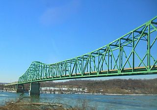
The William S. Ritchie Jr. Bridge, more commonly known as the Ravenswood Bridge, is a two-lane cantilever bridge in the United States, connecting Ravenswood, West Virginia and rural Meigs County, Ohio, across the Ohio River. It has a total length of 2,710 ft (830 m) with a main span of 900 ft (270 m). The bridge was completed in 1981.
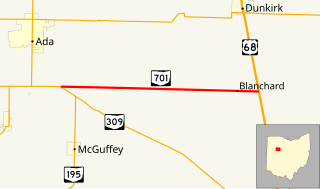
State Route 701 is a 8.96-mile (14.42 km) east–west state highway in western Ohio, a U.S. state. The state highway's western terminus is at a T-intersection with SR 309 nearly 3 miles (4.8 km) southeast of Ada. The eastern terminus of State Route 701 is at U.S. Route 68 (US 68) approximately 3.50 miles (5.63 km) southeast of Dunkirk.
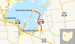
State Route 368 is a short north–south state highway in western Ohio, a U.S. state. SR 368 travels from its southern terminus at SR 366 approximately 1.75 miles (2.82 km) east of Russells Point to its northern terminus on Seminole Island in the eastern half of Indian Lake, at an intersection where it meets Logan County Road 272 (CR 272) and CR 286. Having made its debut in the late 1930s, SR 368 is a two-lane spur route that serves both Indian Lake State Park and communities of cottages that are on two eastern Indian Lake islands: Shawnee and Seminole.

State Route 287 (SR 287) is a 13.69-mile-long (22.03 km) east–west state highway in the western portion of the U.S. state of Ohio. The western terminus of SR 287 is at SR 245 nearly 1.75 miles (2.82 km) east of West Liberty. Its eastern terminus is at an interchange with U.S. Route 33 (US 33) about 5.25 miles (8.45 km) northeast of North Lewisburg that dually serves as the southern terminus of SR 739.

State Route 26 is a 67-mile-long (108 km) north–south route in south eastern Ohio spanning from SR 7 in Marietta to SR 148 between Jerusalem and Bethesda. SR 26 also passes through Graysville and Woodsfield. Where the state route designation ends in Wayne Township, the road continues north as Belmont County Road 26 where it connects to the Barkcamp State Park and the National Road. Much of the route parallels the Little Muskingum River and travels through the heart of Wayne National Forest's Marietta Unit.
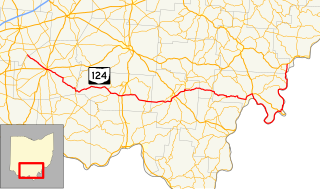
State Route 124 is an east–west state highway in the southern portion of the U.S. state of Ohio. Its western terminus is at State Route 134 nearly 4 miles (6.4 km) southeast of Martinsville, and its eastern terminus is near the unincorporated village of Torch at the concurrency of U.S. Route 50, State Route 7, and State Route 32 in extreme southeastern Athens County. The road passes through numerous villages along its route, many of them economically depressed. State Route 124 has the longest concurrency of state routes in Ohio, running concurrent with State Route 32 for 35½ miles. The road was recently rerouted in 2003 following the extension of U.S. Route 33 to the Ravenswood Bridge.
State Route 266 (SR 266) is a 14-mile-long (23 km) east–west state highway located in the southeastern portion of Ohio. SR 266's western terminus is at an intersection with SR 377 nearly 3 1⁄2 miles (5.6 km) northwest of Stockport, and its eastern terminus is an intersection with SR 60 approximately 4 1⁄2 miles (7.2 km) northwest of Beverly.

State Route 684 is a short north–south state highway in the southern portion of Ohio. Its southern terminus is at State Route 143 in the unincorporated community of Harrisonville, and its northern terminus is at State Route 681 near the community of Pageville.

State Route 202 (SR 202) is a 20-mile (32 km) north–south state highway in the western part of the U.S. state of Ohio. The highway runs from its southern terminus at an intersection with SR 201 in Dayton to its northern terminus at a T-intersection with SR 55 in the eastern end of Troy.

State Route 692 was a short north–south state route in southern Ohio that was located entirely within Meigs County. The southern terminus of SR 692 was at SR 143 approximately three miles (4.8 km) northwest of the hamlet of Harrisonville. Its northern terminus was at SR 681 near the hamlet of Pageville. In 2013, the Ohio Department of Transportation (ODOT) removed SR 692 from the state highway system by making the route north of Pageville an extension of SR 684 and the remainder being transferred to Meigs County's jurisdiction.

State Route 347 (SR 347) is an east–west state highway in central portion of the U.S. state of Ohio. The western terminus of SR 347 is at SR 287 near Middleburg, adjacent to the U.S. Route 33 freeway. Its eastern terminus is at a T-intersection with SR 37 just one-quarter mile (0.40 km) south of the village of Magnetic Springs. The route runs through rural areas of Logan and Union counties passing through no incorporated villages.

State Route 195 (SR 195) is a 3.6-mile-long (5.8 km) north–south state highway in the western portion of the U.S. state of Ohio. SR 195 has its southern terminus at an intersection with Hardin County Route 110 one mile (1.6 km) south of the village of McGuffey. Its northern terminus is at its junction with SR 309 about two miles (3.2 km) north of McGuffey. It is entirely located within western Hardin County.

State Route 733 is a state highway in south-central Meigs County, Ohio. At a length of 2.24 miles (3.60 km) long, the route acts as a connector from State Routes 124 and 833 in the north-easternmost extents of Pomeroy to an interchange with US 33 and SR 7 near the unincorporated community of Five Points within Salisbury Township. The road itself is the former routing of SR 7 before it was moved onto an expressway; following 15 years of county maintenance and control as Meigs County Road 7A, this segment of road assumed state jurisdiction again in late 2013.


