
The Buckingham Canal is a 796 kilometres (494.6 mi)-long fresh water navigation canal, that parallels the Coromandel Coast of South India from Kakinada City in the Kakinada district of Andhra Pradesh to Village near Chidambaram, Cuddalore District of Tamil Nadu, India. The canal connects most of the natural backwaters along the coast to Chennai (Madras) port.

Pulicat Lake is the second largest brackish water lagoon in India,, measuring 759 square kilometres (293 sq mi). A major part of the lagoon lies in the Tirupati district of Andhra Pradesh. The lagoon is one of three important wetlands that attracts northeast monsoon rain clouds during the October to December season. The lagoon comprises the following regions: Pulicat Lake, Marshy/Wetland Land Region (AP), Venadu Reserve Forest (AP), and Pernadu Reserve Forest (AP). The lagoon was cut across in the middle by the Sriharikota Link Road, which divided the water body into lagoon and marshy land. The lagoon encompasses the Pulicat Lake Bird Sanctuary. The barrier island of Sriharikota separates the lagoon from the Bay of Bengal and is home to the Satish Dhawan Space Centre.
Greater Chennai Corporation (GCC) is a local government for the City of Chennai in the Chennai Metropolitan Area of Tamil Nadu, India. Inaugurated on 29 September 1688, under a royal charter issued by King James II of England on 30 December 1687 as the Corporation of Madras, it is the oldest municipal body of the Commonwealth of Nations outside Great Britain. It is the largest municipal corporation in Tamil Nadu with an area of 426 km2. It is headed by a mayor, who presides over 200 councillors, each of whom represents one of the 200 wards of the city. It is the second oldest corporation in the world after the City of London. The city limits, which had been expanded several times over the years, is currently coterminous with the Chennai district. It is one of the four municipal corporations located within the Chennai Metropolitan Area, the other three being the Tambaram Corporation, Avadi City Municipal Corporation and Kanchipuram Municipal Corporation.
The Cooum river, or simply Koovam, is one of the shortest classified rivers draining into the Bay of Bengal. This river is about 72 km (45 mi) in length, flowing 32 km (20 mi) in the city of Chennai and the rest in rural part. The river is highly polluted in the urban area (Chennai). Along with the Adyar River running parallel to the south and the Kosasthalaiyar River, the river trifurcates the city of Chennai and separates Northern Chennai from Central Chennai. It is also sometimes known as Thiruvallikenni river
Velachery is a suburb and neighborhood in Chennai. It is located in the southern part of the city sharing borders with Guindy in the north, Taramani in the east, Perungudi in the south-east, Pallikaranai in the south, Madipakkam in south-west, Adambakkam in the west and north-west. It is the headquarters of Velachery taluk and straddles the boundary between Chennai and Kancheepuram districts.

Pallikaranai is a neighborhood and a residential area in south Chennai, Tamil Nadu, India. Located in proximity to the IT industry in Old Mahabalipuram Road, Chennai's central business districts and the automobile hub in GST road has attracted more population to Pallikaranai in the 2000s. Pallikaranai became a part of the Chennai Corporation in July 2011.
Mugalivakkam is a neighbourhood of Chennai. It is located in Sriperumbudur taluk of Kanchipuram district, in Tamil Nadu. It is situated 16 km south-west of Chennai on the Mount-Poonamallee Road. It is bounded by Porur on the North Meenambakkam and Manapakkam on the South and South East, Madhanandhapuram and Gerugambakkam on the South West and Ramapuram on the North East directions. The nearest railway station is at Guindy which is about 6 kilometres away. Porur junction is around 2 km away and Kathipara Junction is around 5 km away.
Thoraipakkam also spelt Thuraipakkam, also known as Okkiyam Thuraipakkam or Oggiyamduraipakkam, is an area of Chennai, India. It is one of the stops on what is called as the IT expressway, on Old Mahabalipuram Road, now known as Rajiv Gandhi Salai, the first six lane road in Chennai. Okkiyam Thoraipakkam is on the eastern banks of the Pallikaranai marsh which has been designated as a reserve forest area and is one of the few remaining significant natural ecosystems within Chennai. Thoraipakkam is 3 km in length, starting from Perungudi to its north. It is located exactly in the middle of the OMR Road.

Chennai is located at 13.04°N 80.17°E on the southeast coast of India and in the northeast corner of Tamil Nadu. It is located on a flat coastal plain known as the Eastern Coastal Plains. The city has an average elevation of 6 metres (20 ft), its highest point being 60 m (200 ft). Chennai is 2,184 kilometres south of Delhi, 1,337 kilometres southeast of Mumbai, and 1,679 kilometers southwest of Kolkata by road.

Ennore, also spelt Eṇṇūr, is a neighbourhood in Chennai, India. Ennore is situated on a peninsula and is bounded by the Korttalaiyar River, Ennore Creek and the Bay of Bengal. The creek separates south Ennore from the north Ennore which covers major portions of North Chennai Thermal Power Station and Ennore Port. The neighbourhood is served by Ennore railway station. Over the years Ennore has become the hub of a range of industrial projects, mainly thermal power stations, fertilizer factories, industrial ports and coal yards.

The Adyar River, originating near the Chembarambakkam Lake in Kanchipuram district, is one of the three rivers which winds through Chennai (Madras), Tamil Nadu, India, and joins the Bay of Bengal at the Adyar estuary. The 42.5-kilometre (26.4 mi) long river contributes to the estuarine ecosystem of Chennai. Despite the high pollution levels, boating and fishing take place in this river. The river collects surplus water from about 200 tanks and lakes, small streams and the rainwater drains in the city, with a combined catchment area of 860 square kilometres (331 sq mi). Most of the waste from the city is drained into this river and the Cooum.

The Najafgarh drain or Najafgarh nalah, which also acts as Najafgarh drain bird sanctuary, is another name for the northernmost end of River Sahibi, which continues its flow through Delhi, where it is channelized, and then flows into the Yamuna. Within Delhi, due to its channelization for flood control purposes, it is now erroneously called "Najafgarh drain" or "Najafgarh nullah." It gets this name from the once famous and huge Najafgarh Jheel (lake) near the town of Najafgarh in southwest Delhi and within urbanized Delhi. It is the Indian capital’s most polluted water body due to direct inflow of untreated sewage from surrounding populated areas. A January 2005 report by the Central Pollution Control Board classifies this drain, with 13 other highly polluted wetlands, under category ‘‘D’’ for assessing the water quality of wetlands in wildlife habitats.

Pallikaranai Marsh is a freshwater marsh in the city of Chennai, India. It is situated adjacent to the Bay of Bengal, about 20 kilometres (12 mi) south of the city centre, and has a geographical area of 80 square kilometres (31 sq mi). Pallikaranai marshland is the only surviving wetland ecosystem of the city and is among the few and last remaining natural wetlands of South India. It is one of the 94 identified wetlands under National Wetland Conservation and Management Programme (NWCMP) operationalised by the Government of India in 1985–86 and one of the three in the state of Tamil Nadu, the other two being Point Calimere and Kazhuveli. It is also one of the prioritised wetlands of Tamil Nadu. The topography of the marsh is such that it always retains some storage, thus forming an aquatic ecosystem. A project on 'Inland Wetlands of India' commissioned by the Ministry of Environment and Forests, Government of India had prioritised Pallikaranai marsh as one of the most significant wetlands of the country. The marsh contains several rare or endangered and threatened species and acts as a forage and breeding ground for thousands of migratory birds from various places within and outside the country. The number of bird species sighted in the wetland is significantly higher than the number at Vedanthangal Bird Sanctuary.
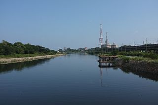
Ennore Creek is a backwater located in Ennore, Chennai along the Coromandel Coast of the Bay of Bengal. It is located in the zone comprising lagoons with salt marshes and backwaters, submerged under water during high tide and forming an arm of the sea with the opening to the Bay of Bengal at the creek. The zone is spread over an area of 4 km2, and the creek covers an area of 2.25 km2. It is located 20 km north of the city centre and 2.6 km south of the Ennore Port, and the creek area stretches 3 km into the sea and 5 km along the coast. The creek is nearly 400 m wide, elongated in northeast–southwest direction and merging with the backwater bodies. Once a flourishing mangrove swamp, the creek has been degraded to patches in the fringes mainly due to human activities in the region. The depth of the creek varies from 1 to 2 m and is shallow near the mouth. The north–south trending channels of the creek connect it with the Pulicat Lake to the north and to the distributaries of the Kosasthalaiyar River in the south. The northwestern part of the creek merges with the tidal flats. The soil in the region is of loamy and alluvial types. Most of the area consists of tracts of alluvial soil and the eastern region comprises beach dunes, tidal flats and creek. The creek is oriented from west to east and opens into the Bay of Bengal to the east at Ennore. The creek acts as an outlet for the excess water from the Poondi reservoir. The creek separates the town of Ennore from the Ennore Port located in the north and the Kattupalli Shipyard located further north. The North Chennai Thermal Power Station is located at the north of the creek and the Ennore Thermal Power Station is located to the south. The creek is part of the Pulicat water system, including the Pulicat lagoon and the Buckingham Canal. As per the 1991 Coastal Regulation Zone notification, the entire Pulicat water system is designated CRZ I. The creek is experiencing siltation due to emergence of the Ennore Port.
Kosasthalaiyar River, also known as Kortalaiyar, is one of the three rivers that flow in the Chennai metropolitan area.

Kovilambakkam is a southern suburb of Chennai, India. It is a village panchayat located in Tambaram taluk, Chengalpattu district in the state of Tamil Nadu, about 26 km from Chennai city center and 12 km from Tambaram. The neighbourhood spans the areas of Sunnambu Kolathur, Chinna Kovilambakkam and Periya Kovilambakkam.
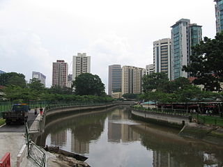
Alexandra Canal is a 1.2-kilometer long functional and concrete canal in Singapore which stretches from Tanglin Road to Delta Road and Prince Charles Crescent. The canal has been converted into a recreational destination as a part of the Active, Beautiful and Clean (ABC) Water Programme undertaken by the Public Utilities Board of Singapore.
The coastal city of Chennai has a metropolitan population of 10.6 million as per 2019 census. As the city lacks a perennial water source, catering the water requirements of the population has remained an arduous task. On 18 June 2019, the city's reservoirs ran dry, leaving the city in severe crisis.
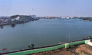
Perungudi Lake is a 50 ares (54,000 sq ft) water body located near Chennai's IT corridor, Rajiv Gandhi Salai, India. It is one of the few protected lakes of Chennai, fully fenced with compound wall and pathways laid on its east and south side for walkers.
Adyar Creek is a backwater estuary located in Adyar, Chennai at the mouth of the Adyar River along the Coromandel Coast of the Bay of Bengal. The creek begins near the Chetinnad Palace, extending northward into the mainland and taking a complete U-turn near the Foreshore Estate before ending near Mandavelipakkam. The creek surrounds the Quibble Island.
