
Refugio County is a county located in the U.S. state of Texas. As of the 2020 census, its population was 6,741. Its county seat is Refugio. The county originated as a municipality of Mexico in 1834 and was classified as a county in 1837.

Carter County is a county in the U.S. state of Oklahoma. As of the 2010 census, the population was 47,557. Its county seat is Ardmore. The county was named for Captain Ben W. Carter, a Cherokee who lived among the Chickasaw.
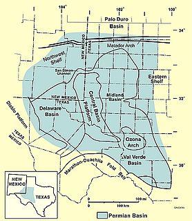
The Permian Basin is a large sedimentary basin in the southwestern part of the United States. The basin contains the Mid-Continent Oil Field province. This sedimentary basin is located in western Texas and southeastern New Mexico. It reaches from just south of Lubbock, past Midland and Odessa, south nearly to the Rio Grande River in southern West Central Texas, and extending westward into the southeastern part of New Mexico. It is so named because it has one of the world's thickest deposits of rocks from the Permian geologic period. The greater Permian Basin comprises several component basins; of these, the Midland Basin is the largest, Delaware Basin is the second largest, and Marfa Basin is the smallest. The Permian Basin covers more than 86,000 square miles (220,000 km2), and extends across an area approximately 250 miles (400 km) wide and 300 miles (480 km) long.

The Mumbai High Field, formerly called the Bombay High Field, is an offshore oilfield 176 km off the west coast of Mumbai, in Gulf of Cambay region of India, in about 75 m of water. The oil operations are run by India's Oil and Natural Gas Corporation (ONGC).

The Wilmington Oil Field is a prolific petroleum field in Los Angeles County in southern California in the United States. Discovered in 1932, it is the third largest oil field in the United States in terms of cumulative oil production. The field runs roughly southeast to northwest through the Los Angeles Basin, stretching from the middle of San Pedro Bay through Long Beach and east of the Palos Verdes Peninsula. The field originally contained approximately 3 billion barrels (480,000,000 m3) of reserves. In 2013, the USGS estimated future potential production from the combined Wilmington-Belmont oilfield could be around 900 million barrels (140,000,000 m3).
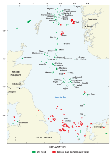
North Sea oil is a mixture of hydrocarbons, comprising liquid petroleum and natural gas, produced from petroleum reservoirs beneath the North Sea.

The Salt Creek Oil Field is located in Natrona County, Wyoming. By 1970, more oil had been produced by this field than any other in the Rocky Mountains region and accounted for 20 percent of the total production in Wyoming.

In structural geology, an anticline is a type of fold that is an arch-like shape and has its oldest beds at its core, whereas a syncline is the inverse of an anticline. A typical anticline is convex up in which the hinge or crest is the location where the curvature is greatest, and the limbs are the sides of the fold that dip away from the hinge. Anticlines can be recognized and differentiated from antiforms by a sequence of rock layers that become progressively older toward the center of the fold. Therefore, if age relationships between various rock strata are unknown, the term antiform should be used.

Ekofisk is an oil field in block 2/4 of the Norwegian sector of the North Sea about 320 km (200 mi) southwest of Stavanger. Discovered in 1969 by Phillips Petroleum Company, it remains one of the most important oil fields in the North Sea. This was the first discovery of oil after the drilling of over 200 exploration wells in the North Sea "triggered" by the Groningen gas field discovery. In 1971, Phillips started producing directly to tankers from four subsea wells. Oil production is planned to continue until at least 2050.

The Statfjord oil field is a large oil and gas field covering 580 km2 in the U.K.-Norwegian boundary of the North Sea at a water depth of 145 m, discovered in 1974 by Mobil and since 1987 operated by Equinor.

Hassi R'Mel is a town in Algeria located near the 18th largest gas field worldwide. Hassi R'Mel is located in Laghouat Province 60 kilometres (37 mi) northwest of Ghardaïa. It is the capital of Hassi R'Mel District. Hassi R'Mel has an airport.

Hassi Messaoud is a town in Ouargla Province, eastern Algeria, located 85 kilometres (53 mi) southeast of Ouargla. As of 2008 it had a population of 45,147 people, up from 40,360 in 1998, and an annual population growth rate of 1.1%, the lowest in the province. Oil was discovered there in 1956 and the town's prominence has grown rapidly since then; it is considered as the First Energy town in Algeria where all the big oil and gas companies have offices and bases. It is an oil refinery town named after the first oil well. A water well, dug in 1917, can be found on the airport side of town. Today there are over 800 wells within a 25 kilometres (16 mi) radius of the town.

Hugoton Gas Field is a large natural gas field in the U.S. states of Kansas, Oklahoma, and Texas. Its name is derived from the town of Hugoton, Kansas, near which the Hugoton Field was first discovered.
The Forties Oil Field is the second largest oil field in the North Sea, after the Clair oil field, which is located 110 miles east of Aberdeen. It was discovered in 1970 and first produced oil in 1975 under ownership of British Petroleum, now called BP.

The Sirte Basin is a late Mesozoic and Cenozoic triple junction continental rift along northern Africa that was initiated during the late Jurassic Period. It borders a relatively stable Paleozoic craton and cratonic sag basins along its southern margins. The province extends offshore into the Mediterranean Sea, with the northern boundary drawn at the 2,000 meter (m) bathymetric contour. It borders in the north on the Gulf of Sidra and extends south into northern Chad.
The Hassi R'Mel Gas Field is the largest gas field in Algeria and one of the largest gas fields in the world. It is located in the vicinity of Hassi R'Mel village, 550 kilometres (340 mi) south of Algiers. The gas field extends 70 kilometres (43 mi) from north to south and 50 kilometres (31 mi) from east to west.

Masterson is an unincorporated community in southern Moore County, Texas, United States of the Texas Panhandle. It lies along the concurrent U.S. Routes 87 and 287, south of the city of Dumas, the county seat of Moore County. Its elevation is 3,704 feet (1,129 m). Although Masterson is unincorporated, it has a post office, with a ZIP code of 79058.
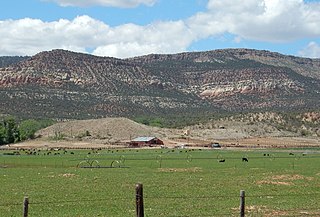
In geology, the Paradox Formation Is a Pennsylvanian age formation which consists of abundant evaporites with lesser interbedded shale, sandstone, and limestone. The evaporites are largely composed of gypsum, anhydrite, and halite. The formation is found mostly in the subsurface, but there are scattered exposures in anticlines in eastern Utah and western Colorado. These surface exposures occur in the Black Mesa, San Juan and Paradox Basins and the formation is found in the subsurface in southwestern Colorado, southeastern Utah, northeastern Arizona and northeastern New Mexico.

The Lacq gas field is a natural gas field located in Aquitaine. It was discovered in 1950 and developed by and Total S.A. It began production in 1958 and produces natural gas and condensates. The total proven reserves of the Lacq gas field are around 8.8 trillion cubic feet (251 km³), and production is slated to be around 1 billion cubic feet/day (35×105m³).

The Delta Field is located offshore from Nigeria on Oil Mining Leases (OML) 49 and 95. This is located within the Niger Delta Basin and sits in 12 feet of water. In 1965, the Delta 1 well was completed and the Delta Field opened in 1968 for production.

