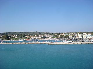
Oktonia is a hillside village found in the east-central area of Evia Island, belonging to the Municipality of Kimi-Aliveri, Greece. Located near the lower side of the Gulf of Kimi, the village is composed of four communities, Alonia, Panochori (the upper village), Katochori (the lower village) and Panagia, covering a large area. It is 145km from Athens, a distance covered in about 2.5 hours by car, making it a destination for both winter and summer holidays. According to the census of 2011, Oktonia has 455 permanent inhabitants.
Including the coastal communities of Agios Mercurios and Mourteri, the population is 650.
History and origins
The area of Oktonia has been inhabited since antiquity. The geographer Strabon (64 or 63 BC-c. 24 AD) wrote about Ochalia,a settlement apparently in the same location according to many scholars. Research indicates that there was a temple dedicated to Chthonia Demetra, the goddess Demetra who was the protector of the earth (chthon), and more specifically, agriculture and agricultural production.
From a compilation of historical data and traditional legend, it appears that during the late Byzantine Period, there was a village in the shadow of Kallimani Mountain just east of today’s village of Choreftaria. Groups of herders also grazed their flocks in the surrounding area. During this period, piracy was rampant; this village could not survive due to the fact that it was discernible to pirates from the sea.
According to tradition, one night during a festive gathering, when the watchtowers were unattended, pirates landed from the sea of Aili where their ships were moored. A woman who had perhaps learned of their plan, took her eight daughters and fled toward Kourvinou to escape the pirate raid. The rest of the villagers were captured and taken to the slave market in Anatolia. After some time, the mother and her daughters returned to the area but settled in a densely forested ravine at the foot of the mountain for protection from the pirates. Their initial settlement was on the site of present-day Panochori.
Rizovouni. This is the mountain where the village began.Pirates landed from the sea of Aili where their ships were moored.
Around AD 1420, a village was founded and named Oktonees and later Oktonia (okto is the Greek for eight), for the eight young girls (nees) who escaped the pirates and first settled it. Development of this settlement over the years created present-day Oktonia.
During the Turkish Occupation, the local population found comfort in religion from their suffering and humiliation, and there were four monasteries founded by the mid-16th century. Today, from these monastery complexes only the churches survive: St. George at Koutsouro, the Taxiarches (Archangels) at Kotsikia, the Presentation of the Virgin at Papavlassa, and St. Demetrios of the Waterfall.
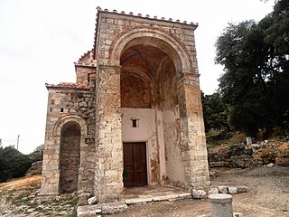
Of these churches, St. Demetrios of the Waterfall is most noteworthy because the monastery played a significant role in the years leading up to the revolutionary struggle of 1821. The church contains important examples of post-Byzantine painting. In 1921, by Royal Decree this church became a Prominent Monument of the State.
During the 1821 Revolution, many people from the village fought and died to attain their freedom. The mountainous terrain favored the resistance and, because of its struggle against the Ottomans, Oktonia experienced battles, a siege on the castle (Kastro), torture and massacres. The abbot of the Monastery of St. Demetrios, Paisios, was put to death by impalement.
Oktoniates (people from Oktonia) also demonstrated their courage, patriotism and self-sacrifice during the subsequent National Liberation struggles including the Balkan Wars 1912-13, the Asia Minor Expedition and World War II.
The history of Oktonia during this period was turbulent. The villagers suffered, were attacked, taken into captivity, and many were killed, but they demonstrated resistance, bravery, sacrifice, heroism and a will to survive. As a result of these experiences, the people of Oktonia became industrious, inventive, resilient, progressive, and persistent in achieving their aims.
Oktonia today
Community buildingCultural events
Today Oktonia is a large, charming village of both new and renovated old houses with traditional tile roofs. Modern conveniences combine with age-old traditions in all aspects of village life. From the architectural standpoint, Oktonia is characterized as an Interesting Settlement with important structural and town-plan elements. These same pleasing elements are also found in the coastal settlements of Mourteri and Agios Mercurios.
The village people are engaged in many occupations. They are farmers, stock-breeders, fishermen, beekeepers, masons, artisans, clerks, laborers, sailors and shopkeepers.
There are two parish churches and a community center. The village has a primary pchool, 5 x 5 football field, basketball court, cafes, grocery stores, butcher shops, pastry & bakery shops, tavernas, bars and restaurants to meet the needs of residents and visitors alike.
In addition to the Agricultural Cooperative, there are several other groups and associations in Oktonia:
The Association of Parents and Guardians of the Oktonia Primary School
These organizations cooperate and assist each other in promoting the general welfare of the people. Individually and collectively, they host a number of cultural, educational, recreational and sporting events, without abandoning the village traditions.
Geography and natural environment
View of the village from the mount Kallimani
Geographical location
Oktonia covers an area of 34,000 stremmata or 8,402 acres. Below the Kallimani Mountain, which is still bare from the fires during Ottoman rule, the village lies amidst dense forest at an elevation of 400 meters. Oktonia overlooks the hill of Oksilithos, the plain, and neighboring villages and offers a splendid view of the Aegean Sea.
Climate
The climate of the village is mild, dry and healthy. Winter temperatures are not too cold and it is pleasantly cool in the summer due to the low humidity. The sea and land air are especially beneficial for people with respiratory conditions.
Agriculture, stock-breeding and fishing
View on the way to Mourteri settlement.
Oktonia has a great deal of arable land and plenty of water, making it ideal for the cultivation of agricultural products. There are large olive groves and the primary products are olive oil and onions. The largest part of the village itself is in the midst of walnut and plane trees, among others.
Stock-breeding is widespread in Oktonia. Herds of goat and sheep graze the hills freely.
Finally, there are many opportunities for professionals and amateurs alike to fish the abundant seas in close proximity to the village. Beaches such as Bournia are frequented by local people and visitors.
Interesting sites and leisure activities
Picturesque communities and their natural springs (fountains)
Scattered among the four settlements of the village are a number of ornate fountains, some old and others new, each with its own story. The best known are: Marinou, Sgourou, Skoura, Karvouniari and Mitsara in Panohori (upper village), and Voivonta in Alonia, Ambades in Panagia and Soor in Katohori (lower village).
St. Demetrios of the Waterfall
St. Demetrios of the Waterfall
In 1921, by Royal Decree the St. Dimitrios' church became a Prominent Monument of the State.
The church remains today an important religious, historic and artistic monument. The monastery, which was located on the site, was a spiritual center inspiring freedom-fighters for the 1821 Revolution and also supplying the Greek Revolutionary ships that were in the sea of Markourio. This role in the Revolution resulted in the capture of the abbot of the monastery, Paisios, who was put to death by impalement.
The church interior is completely covered with extraordinary post-Byzantine paintings (1600), which depict a wide variety of religious themes in original, colorful compositions. It was deemed a Prominent Monument of the State by Royal Decree in 1921. As such, it took its place among the important Byzantine and post-Byzantine monuments of Greece such as the Monastery at Daphne and Osios Loukas.
Kastri and the historic castle (Kastro)
Kastri
On the slopes of the mountain of Oktonia, Kallimani, is the area of Kastri, which took its name from the medieval castle (Kastro) located on the mountain. From the Kastro all the other medieval castles in the area were visible: the Castle of Dragoneras, the Tower of Kipon, etc. All of these castles were able to communicate among themselves by lighting torches on their towers. During the years leading up to the Revolution of 1821, the people of Oktonia took refuge in these fortresses against the attacks of the Turks who were under the leadership of the Pasha of Karistos, Ontabassin. Following a treasonous act, the castle was besieged and bombarded. The women and children fled to other areas, the aged and the weak were slaughtered and the fighters escaped to the mountains in order to organize their subsequent revolutionary actions. In retribution, the Turkish fighters burned the monastery of St. Demetrios and the entire area around Oktonia.
Inside the castle walls is the Church of the Transfiguration of the Savior (Metamorphoseos tou Sotiros). On this site people sacrificed their lives for the cause of freedom. It has become a place of pilgrimage; visitors come for prayer, giving thanks, and glorifying God. Beside the church is a well fed by a cistern which gathered rain water to meet the needs of the people when the castle was under siege. From the castle, visitors have a panoramic view of Oktonia and the villages of Kimi. The castle can be reached by car.
In close proximity to the Kastro, on the side of the mountain facing Oktonia, is a cave four meters deep with an entrance three meters high. The approach to the castle may also be made by following a footpath which begins at Gorthia, a little below the Voivonta Fountain.
Byzantine and post-Byzantine churches (15th and 16th centuries)
St. George at Koutsouro
St. George at Koutsouro, the Taxiaches (Archangels) at Kotsikia, the Presentation of the Virgin at Papavlassa and St. John the Theologian at Karvouni are noteworthy churches in the area.
New churches
There are about seventeen new churches scattered in various locations in the area. Of special interest among these churches are the historic church of Zoodochos Pigi in Tsouka and St. John the Baptist which is between Alonia and Panagia.
Beaches
Agios Merkurios beach
Along the ten kilometer sea coast of Oktonia are the beaches of Mourteri, Agios Mercurios, Bournias, Graves, Limionari, Aili and Kalami.
Cape Punta sea caves
View from the top of mount Kallimani
Some of the caves along Cape Punta provided hiding places for people of Oktonia escaping the Turks. They waited for passing Greek ships to take them to other islands.
Mountain destinations
From the peak of Kallimani Mountain (elevation 750 meters) visitors have a panoramic view of the coast and the Aegean. Skyros and the Northern Sporades Islands can also be seen.
Boti's Cave (Tripa)
Botis Cave (Tripa) is in the area of Kakorrema (after Drimo) and has stalactites and stalagmites. It can be accessed by car, followed by a 15-minute hike. For the descent, a rope is required.
Around the top of the mountain of Kallimani there are other caves including:
The cave Agiasma or Graspilaia situated at Askala a short distance from Boti's Cave (Tripa). Finds here include ceramic objects and shards, and bones from the Proto-Helladic period (3200-2000 BC).
The Cave of Zoodochos Pigi is a small cave in the church yard in Tsouka. The icon of the Virgin Mary was found in the cave, and the church of Zoodochos Pigi was built to honor it.
The cave at Pigadi is relatively close to Zoodochos Pigis. It is a horizontal cave with an entrance two meters high, width of 60 centimeters and length of four to five meters.
The Cave of Bonou or Bonista is located 200 meters from the cave at Pigadi. It has a length of five meters and depth of ten meters. Research inside the cave yielded a few prehistoric shards and many shards from the post-Roman historical period (4th-5th c. AD).
The Cave of Bourboula is found on the northeast side of Kallimani Mountain at an elevation of 400 meters. The entrance has a width of five meters and maximum height of three meters. The cave was used seasonally as a shelter for herds of goats.
The Cave of the Transfiguration (Metamorphoseos) is found at Kastri (Kastro of Oktonia) near the church. It has a depth of four meters with an entrance three meters high. Research yielded shards perhaps from prehistoric times and from more recent periods. The cave was used in the past as a shelter for herds of goats.
Naxos is a Greek island and the largest of the Cyclades. It was the centre of archaic Cycladic culture. The island is famous as a source of emery, a rock rich in corundum, which until modern times was one of the best abrasives available.
Kastro-Kyllini is a former municipality in Elis, West Greece, Greece. Since the 2011 local government reform it is part of the municipality Andravida-Kyllini, of which it is a municipal unit. The municipal unit has an area of 49.322 km2. The population was 3,622 in 2011. The municipality Kastro-Kyllini was created in 1999 as part of the Kapodistrias reform from the formerly independent communities Kyllini, Kato Panagia, Kastro and Neochori, that became municipal districts. After the 2011 Kallikratis reform, these municipal districts became (dependent) communities. Its seat of administration was the small port town of Kyllini.
Voies is a former municipality in Laconia, Peloponnese, Greece. Since the 2011 local government reform it is part of the municipality Monemvasia, of which it is a municipal unit. The municipal unit has an area of 215.527 km2. It is on the southern tip of Cape Malea. It is a predominantly agricultural region with a few minor villages and one dominant town. Vatika is the common term for the area, but Voies is used in a more official context, particularly for postal situations. Voion, the genitive, is used for description: for example, to differentiate the village of Agios Nikolaos in Voies from other villages and towns of the same name, one would use Agios Nikolaos Voion. Neapoli is the administrative capital of the municipality, and is also the urban center to the numerous villages that surround the hinterland.
Troodos is the largest mountain range in Cyprus, located in roughly the center of the island. Its highest peak is Mount Olympus, also known as Chionistra, at 1,952 metres (6,404 ft), which hosts the Sun Valley and North Face ski areas with their five ski lifts.
Lampeia is a mountain village, a community and a former municipality in Elis, West Greece, Greece. Since the 2011 local government reform it is part of the municipality Archaia Olympia, of which it is a municipal unit. The municipal unit has an area of 72.447 km2. In 2011 the population of the village was 468, and of the community, which includes the village Amygdali, 529.
Skiathos is a small Greek island in the northwest Aegean Sea. Skiathos is the westernmost island in the Northern Sporades group, east of the Pelion peninsula in Magnesia on the mainland, and west of the island of Skopelos.
Sifnos is an island municipality in the Cyclades island group in Greece. The main town, near the center, known as Apollonia, is home of the island's folklore museum and library. The town's name is thought to come from an ancient temple of Apollo on the site of the church of Panayia Yeraniofora. The second-largest town is Artemonas, thought to be named after an ancient temple of Apollo's sister-goddess Artemis, located at the site of the church of Panayia Kokhi. The village of Kastro, was the capital of the island during ancient times until 1836. It is built on top of a high cliff on the island's east shore and today has extensive medieval remains and is the location of the island's archeological museum. The port settlement, on the west coast of the island is known as Kamares.
Kythnos, commonly called Thermia, is a Greek island and municipality in the Western Cyclades between Kea and Serifos. It is 56 nautical miles (104 km) from the Athenian harbor of Piraeus. The municipality Kythnos is 100.187 km2 (38.68 sq mi) in area and has a coastline of about 100 km (62 mi). Mount Kakovolo is island's highest peak (365m).
Agios Nikolaos is a village located 110 kilometers south-east of Thessaloniki on the Chalkidiki peninsula in Macedonia, Greece.
Xorko t kwtsiou j t champi
Velanidia is a village in Laconia, Greece, within the municipality of Monemvasia. It is situated at the southern edge of Peloponnese at the southeast edge of mountain range Parnon. It includes several Byzantine churches, giving it the nickname Small Agios Oros. This village is near Cape Maleas.
Zoodochos Pigi, Greek for Life-giving Spring, may refer to:
Agios Alexandros is a settlement in the northeastern part of the Aegean island of Lemnos, Greece. It is part of the municipal unit of Moudros and the community of Kontopouli. The population was 0 at the 2011 census. It is located north of the Alyki Lagoon, 4 km southwest of Panagia and 5 km northeast of Kontopouli.
The Painted Churches in the Troödos Region is a UNESCO World Heritage Site in the Troödos Mountains of central Cyprus. The complex comprises ten Byzantine churches and monasteries richly decorated with Byzantine and post-Byzantine murals:
Church of Agios Nikolaos tis Stegis in Kakopetria: An 11th-century monastery and the oldest surviving katholikon in Cyprus
Agios Ioannis Lampadistis Monastery in Kalopanagiotis: A 13th-century monastery
Church of Panagia Phorviotissa (Asinou) in Nikitari: A 12th-century church
Church of Panagia tou Arakou in Lagoudhera: A 12th century church
Church of Panagia in Moutoullas: A 13th-century chapel and the earliest example of steep-pitched wooden roofs
Church of Archangelos Michael in Pedoulas: A late 15th-century church
Church of Timios Stavros in Pelendri: A church containing unique 14th-century wall paintings
Church of Panagia Podithou in Galata: An early-16th century church
Church of Stavros Agiasmati in Platanistasa: A 14th-century church
Church of Agia Sotira tou Soteros in Palaichori Oreinis: A 16th-century church.
Kontopouli is a village and a community in the municipal unit of Moudros in the northeastern part of the island of Lemnos, Greece. In 2011 its population was 623 for the village and 634 for the community, which includes the small villages Agios Alexandros and Agios Theodoros. Its total area is 37.04 km². Kontopouli is 1 km northwest of Kalliopi, 3 km east of Repanidi and 8 km northeast of Moudros.
Repanidi is a village and a community in the northeast of the island of Lemnos, Greece. It is part of the municipal unit of Moudros. It is located 2 km northeast of Romanou, 3 km west of Kontopouli, 3 km east of Lychna, 6 km northeast of Moudros and 21 km northeast of Myrina. In 2011 its population was 266 people. Its elevation is 30 m.
Exarchos is a Greek village in Phthiotis prefecture. It is located in the southern part of Phthiotis, in Locris, 18 Km west of Atalanti. The village is located on the slope of Mount Chlomo at a height of about 300 meters. Its population is 699 inhabitants according to 2011 census. Exarchos belongs to Lokroi municipality.
The Church of Zoodochos Pigi is a Byzantine-era church in the village of Pyli, Boeotia, originally part of a monastery.
Kefalari is the name of the village and community Kefalari in Argolis. Several Greek villages in mountainous areas, where spring water is abundant, have similar names; this article is about the community at the northern border of the “Plain of Argos”, Peloponnese, at the Argolic Gulf. The village developed around a large geologically significant karst spring. In the mythology and the life of ancient Greeks this spring was of importance and today it is a place of orthodox pilgrimage.
This page is based on this Wikipedia article Text is available under the CC BY-SA 4.0 license; additional terms may apply. Images, videos and audio are available under their respective licenses.