Old Church of St Andrew, Upleatham

Last updated

Old Church of St Andrew
Old Church of St Andrew from NE.jpg
Old Church of St Andrew
Old Church of St Andrew, Upleatham
54°33′54″N1°00′58″W / 54.565°N 1.016°W / 54.565; -1.016
Location Upleatham, Redcar and Cleveland
CountryEngland
Denomination Anglican
Listed Building – Grade II*
Designated25 April 1954
Reference no. 1139759

The Old Church of St Andrew is a redundant grade II* listed Anglican church in the village of Upleatham, Redcar and Cleveland, England. Parts of the church date back to the 12th century, and it was replaced as a working church by the newer Church of St Andrew, which is located closer to the village, the old church being outside of Upleatham. Although no longer used for services, the church is noted as being one of the smallest in England.

Contents

History

The Old Church of St Andrew is noted as being one of the smallest churches in England, due to its size of just 20 feet (6 m) by 13 feet (4 m) [1] (only one church in England is smaller - Bremilham Church in Wiltshire). [2] The church was historically bigger than the size it is today, with historians believing that in 1684, when the tower was added, the south side of the church was removed. [3] The current size of the church only allows 30 worshippers inside. [4]

The church is thought to have existed since at least the 12th century, and the first mention of the church at Upleatham is when it was given to the canon and priors of Gisborough Priory, who had parochial rights over the area. [5] The Brus family donated most of their land and the churches to Gisborough Priory c.1119, around the time of the priory's founding. [6]

Excavations on the site in 1911 unearthed a ninth century Anglo-Danish cross, which suggests the village existed pre-dates the Domesday survey. [7] In 1974, further archaeological digs revealed some fragments of a cross that dates back to the 10th century. [8] The church is 0.5-mile (0.80 km) outside of the village to the east along the B1268 road. [9] [10] It is thought that the village was moved to its present location in the 16th–17th century, but the reasons for the re-location, and leaving the church alone, are unknown. [11]

All that remains of the church is the west end of the nave, which is Norman in architecture, an embattled tower on the west side, and fragments of the ruined church on the eastern side. [12] [13] Archaeological investigations of the church's footprint and the ruins, have lead to an estimation that the original nave was 36 feet (11 m) long by 18 feet 9 inches (5.72 m) wide. [3] The east wall is a later addition to the fabric of the church, believed to have been erected when the rest of the church was removed in 1822. [1] In the eastern part of the churchyard is a low wall, part of the original church and the location of the Lowther Vault. [14]

The church is within the boundary of the Upleatham conservation area, and was grade II* listed in 1954. [15] [16] It is maintained by the National Churches Trust. [17] From the 1830s, services were moved to the newer Ignatius Bonomi designed St Andrew's Church in the same village, however, this also ceased being an active church in 1989, and has been converted into a private home. [18] [8] [19] [20] After being supplanted by the newer church, the Old Church of St Andrew became a mortuary chapel. [21]

Related Research Articles

<span class="mw-page-title-main">Guisborough</span> Market town in North Yorkshire, England

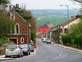
Guisborough is a market town and civil parish in the borough of Redcar and Cleveland, North Yorkshire, England. It lies north of the North York Moors National Park. Roseberry Topping, midway between the town and Great Ayton, is a landmark in the national park. At the 2011 census, the civil parish with outlying Upleatham, Dunsdale and Newton under Roseberry had a population of 17,777, of which 16,979 were in the town's built-up area. It was governed by an urban district and rural district in the North Riding of Yorkshire.

<span class="mw-page-title-main">Gisborough Priory</span> Ruined Augustinian priory in Guisborough, North Yorkshire, England

Gisborough Priory is a ruined Augustinian priory in Guisborough in the current borough of Redcar and Cleveland, North Yorkshire, England. It was founded in 1119 as the Priory of St Mary by the Norman feudal magnate Robert de Brus, also an ancestor of the Scottish king, Robert the Bruce. It became one of the richest monastic foundations in England with grants from the crown and bequests from de Brus, other nobles and gentry and local people of more modest means. Much of the Romanesque Norman priory was destroyed in a fire in 1289. It was rebuilt in the Gothic style on a grander scale over the following century. Its remains are regarded as among the finest surviving examples of early Gothic architecture in England.

<span class="mw-page-title-main">Eston</span> Area of Redcar and Cleveland, North Yorkshire, England

Eston is an area of Redcar and Cleveland in North Yorkshire, England. The local authority ward covering the area had a population of 7,005 at the 2011 census. It is part of Greater Eston, which includes the outlying settlements of Grangetown, Normanby, South Bank, Teesville and part of Ormesby.

<span class="mw-page-title-main">Middlesbrough</span> Town in North Yorkshire, England

Middlesbrough is a town in the Middlesbrough unitary authority borough of North Yorkshire, England. The town lies near the mouth of the River Tees and north of the North York Moors National Park. The built-up area had a population of 148,215 at the 2021 UK census. It is the largest town of the wider Teesside area, which had a population of 376,633 in 2011.

<span class="mw-page-title-main">Redcar and Cleveland</span> Borough in North Yorkshire, England

Redcar and Cleveland is a unitary authority area with borough status in North Yorkshire, England.

<span class="mw-page-title-main">Redcar</span> Town in North Yorkshire, England

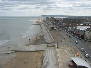
Redcar is a seaside town on the Yorkshire Coast in the Redcar and Cleveland unitary authority in the ceremonial county of North Yorkshire, England. It is located 7 miles (11 km) east of Middlesbrough.

<span class="mw-page-title-main">Marton, Middlesbrough</span> Area of Middlesbrough, North Yorkshire, England

Marton is an area of Middlesbrough, North Yorkshire, England. Until the 1950s, it was a small village next to the hamlet of Tollesby in Yorkshire's North Riding.

<span class="mw-page-title-main">Marske-by-the-Sea</span> Village in North Yorkshire, England

Marske-by-the-Sea is a village in the unitary authority of Redcar and Cleveland and the ceremonial county of North Yorkshire, England. It is located on the coast, between the seaside resorts of Redcar and Saltburn-by-the-Sea, although it is not itself a seaside resort. Marske is in the civil parish of Saltburn, Marske and New Marske and comprises the wards of Longbeck and St Germains.

<span class="mw-page-title-main">Normanby, Redcar and Cleveland</span> Area of Redcar and Cleveland, North Yorkshire, England

Normanby is an area in the borough of Redcar and Cleveland, North Yorkshire, England. A ward covering the area had a population of 6,930 at the 2011 census. It is part of Greater Eston, which includes the area and the outlying settlements of Eston, Grangetown, South Bank, Teesville and part of Ormesby.

<span class="mw-page-title-main">Ormesby</span> Area of Middlesbrough, North Yorkshire, England

Ormesby a village in North Yorkshire, England. Its governance is split between two unitary authorities, to the north Middlesbrough and to the south Redcar and Cleveland, both are part of the devolved Tees Valley area. It is in the Middlesbrough part of the Teesside built up area.

<span class="mw-page-title-main">South Bank, Redcar and Cleveland</span> Town in North Yorkshire, England

South Bank is a former industrial town in the Redcar and Cleveland borough in North Yorkshire, England on the south bank of the River Tees. It is 3 miles (4.8 km) east of Middlesbrough and 6 miles (9.7 km) south-west of Redcar. The town is served by South Bank railway station.

<span class="mw-page-title-main">Brotton</span> Village in North Yorkshire, England

Brotton is a village in the civil parish of Skelton and Brotton, in the Redcar and Cleveland district, in the ceremonial county of North Yorkshire, England It is situated approximately 2.5 miles (4 km) south-east of Saltburn-by-the-Sea, 9 miles from Redcar, 12 miles (19 km) east of Middlesbrough and 14 miles (23 km) north-west of Whitby.

<span class="mw-page-title-main">Upleatham</span> Village in North Yorkshire, England

Upleatham is a village in the civil parish of Guisborough, in the unitary authority area of Redcar and Cleveland and the ceremonial county of North Yorkshire, England. The village was mentioned in the Domesday Book and the name derives from Old English and Old Norse as Upper Slope, in that it was further up the hill than Kirkleatham.

<span class="mw-page-title-main">Grangetown, North Yorkshire</span> Area of Redcar and Cleveland in North Yorkshire, England

Grangetown is an area in the borough of Redcar and Cleveland, North Yorkshire, England. The area is 3 miles (4.8 km) east of Middlesbrough and 4 miles (6.4 km) from south-west of Redcar.

<span class="mw-page-title-main">Robert de Brus, 1st Lord of Annandale</span> Early 12th century Anglo-Norman baron and knight

Robert I de Brus, 1st Lord of Annandale was an early-12th-century Anglo-Norman lord and the first of the Bruce dynasty to hold lands in Scotland. A monastic patron, he is remembered as the founder of Gisborough Priory in Yorkshire, England, in present-day Redcar and Cleveland, in 1119.

<span class="mw-page-title-main">Gisborough Hall</span> 19th-century mansion house, now hotel, in northern England

Gisborough Hall is a 19th-century mansion house, now a hotel, at Guisborough, Redcar and Cleveland, England. It is a Grade II listed building.

<span class="mw-page-title-main">Kilton Castle</span> Former castle in North Yorkshire, England

Kilton Castle is a ruined castle overlooking the valley of Kilton Beck, near to the village of Kilton in the historic county of the North Riding of Yorkshire in England. The castle was built in the 12th century and was described as being in a ruinous state by the 14th century, with it being totally abandoned by the 16th century. Kilton Castle was owned by several noble families who hailed from the area; de Brus, de Kilton, Autrey, de Thweng, de Lumley.

<span class="mw-page-title-main">Church of St Peter ad Vincula, Thornaby-on-Tees</span> Anglican church in North Yorkshire, England

The Church of St Peter ad Vincula, Thornaby, is an Anglican church in Thornaby, North Yorkshire, England. The structure, which is grade II* listed, is dated to the 12th century, replacing an earlier building on the same site. The church is noted for being the supposed baptismal location of Grace Pace, Captain Cook's mother.

<span class="mw-page-title-main">St Germain's Churchyard</span> Cemetery in Yorkshire, England

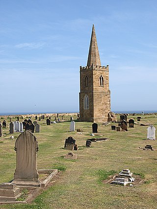
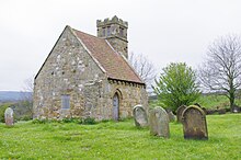
St Germain's Churchyard is a large cemetery overlooking the North Sea at Marske-by-the-Sea, North Yorkshire, England. Its church tower is a grade II listed structure at the midpoint to the yard and a landmark for sailors out on the sea. It is a remnant of a demolished church, services at St Germain's were replaced in 1876 by St Mark's.

<span class="mw-page-title-main">Hunt Cliff</span> Cliff in North Yorkshire, England

Hunt Cliff is a sea cliff or promontory, located between Saltburn and Skinningrove, in Redcar and Cleveland, on the Yorkshire Coast in England. Whilst Hunt Cliff is not as high as the nearby cliffs at Boulby, the view of it from Saltburn has been described as "very striking". Historically, the cliff has had many uses, being a signal station for the Romans, a place to mine ironstone, and a radar station during the Second World War. The Cleveland Way long-distance path traverses the cliff edge.

References

  1. 1 2 Annis 1991, p. 5.
  2. "Cowage Bremilham Church". nationalchurchestrust.org. Retrieved 19 February 2024.
  3. 1 2 Page 1968, p. 413.
  4. Taylor, Richard (2004). How to read a church: an illustrated guide to images, symbols and meanings in churches and cathedrals. London: Rider. p. 29. ISBN   9781844132386.
  5. Ord, John Walker (1846). The history and antiquities of Cleveland : comprising the wapentake of East and West Langbargh[ sic ], North Riding, County York. London: Simpkin and Marshall. p. 349. OCLC   1048899800.
  6. Blakely, Ruth Margaret (2005). The Brus family in England and Scotland, 1100-1295. Woodbridge: Boydell press. p. 169. ISBN   1-84383-152-X.
  7. UCAA 2011, p. 3.
  8. 1 2 Lang, James (2001). Corpus of Anglo-Saxon Stone Sculpture, Volume VI: Northern Yorkshire. Oxford: Oxford University Press. p. 215. ISBN   9780197262566.
  9. UCAA 2011, p. 11.
  10. Knight, Shirley (1976). "St Andrew's Old Church, Upleatham". In Addeyman, Peter; Morris, Richard (eds.). The archaeological study of churches. London: The Council for British Archaeology. p. 40. ISBN   0-900312-35-1.
  11. UCAA 2011, p. 4.
  12. Page 1968, p. 412.
  13. Pevsner, Nikolaus (2002) [1966]. Yorkshire, the North Riding. London: Yale University Press. p. 377. ISBN   0-300-09665-8.
  14. Annis 1991, p. 7.
  15. UCAA 2011, p. 25.
  16. Historic England. "Old Church of St Andrew (Grade II*) (1139759)". National Heritage List for England . Retrieved 15 February 2024.
  17. "Upleatham St Andrew Old Church". nationalchurchestrust.org. Retrieved 15 February 2024.
  18. UCAA 2011, p. 5.
  19. Tims, Anna (28 October 2016). "A converted church in North Yorkshire – in pictures". The Guardian. Retrieved 15 February 2024.
  20. Webster, Christopher; Brandwood, Geoff (2022). Late-Georgian churches: Anglican architecture, patronage and churchgoing in England, 1790-1840. London: John Hudson Publishing. p. 289. ISBN   978-1-7398229-0-3.
  21. Cook, Hugh (30 August 1909). "Ancient history of Upleatham". The North Star. No. 8, 889. p. 3. OCLC   751720286.

Sources