
The S Bridge is a historic stone arch bridge, spanning Salt Fork about 4 miles (6.4 km) east of Old Washington, Ohio. Built in 1828, it is one of the best-preserved surviving bridges built for the westward expansion of the National Road from Wheeling, West Virginia to Columbus, Ohio. S bridges derive their name from the sharply curving approaches to the span. The bridge was designated a National Historic Landmark in 1964. The bridge is closed to traffic, and may be seen from Blend Road on the north and Rhinehart Road on the south.

The Old Town Bridge is a historic stone arch bridge in Wayland, Massachusetts. It is located just north of Old Sudbury Road, and is sited across what was formerly a channel of the Sudbury River, which now flows just west and north of the bridge. The four-arch bridge was built in 1848 by Josiah Russell on a site where it is supposed that the first bridge in Middlesex County was built in the 1640s. It was for many years on the major east–west route connecting Boston to points west and south. Originally built of dry-laid stone, the bridge was rebuilt with mortar after being damaged by flooding in 1900. It is 60 feet (18 m) long and has a roadbed 20 feet (6.1 m) wide, with each arch spanning about 10 feet (3.0 m). The bridge was open to vehicular traffic until 1955.

The County Farm Bridge is a historic stone arch bridge in Wilton, New Hampshire. Built in 1885, it carries Old County Farm over Whiting Brook, just south of its northern junction with Burton Highway in a rural section of northwestern Wilton. It is an unusually late and well-preserved example of a 19th-century stone arch bridge, and was listed on the National Register of Historic Places in 1981.

The Coombs Covered Bridge is a wooden covered bridge which carries Coombs Bridge Road over the Ashuelot River in northern Winchester, New Hampshire. It was built in 1837, and is one of the state's small number of surviving 19th-century covered bridges. It was listed on the National Register of Historic Places in 1976.

The East Putney Brook Stone Arch Bridge is a historic stone arch bridge in eastern Putney, Vermont. Built in 1902, it is a rare statewide example of a 20th-century stone bridge, and one of a number of such area bridges built by Townshend farmer and mason James Otis Follett. It was listed on the U.S. National Register of Historic Places in 1976. The bridge is located just west (upstream) of the present alignment of River Road, which it formerly carried.

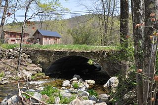
The Stone Arch Bridge is a stone arch railroad bridge in Keene, New Hampshire, United States. Built in 1847 to carry the Cheshire Railroad, it is one of the best-preserved pre-1850 stone arch bridges in the nation. The bridge was listed on the National Register of Historic Places in 2012, and the New Hampshire State Register of Historic Places in 2006. It now carries a multi-purpose rail trail.

The Stone Arch Underpass is a historic stone arch bridge spanning Glen Road in Lebanon, New Hampshire. Built about 1848, it carried the Boston and Maine Railroad's former Northern Line. It is one of a small number of 19th-century stone arch bridges in the state, and the only one known in central western New Hampshire. The bridge was listed on the National Register of Historic Places in 1985. The railroad right-of-way has been functionally abandoned, and the bridge may become part of a continuation of the Northern Rail Trail.

The Follett Stone Arch Bridge Historic District encompasses a group of four stone arch bridges in southwestern Townshend, Vermont. All four bridges were built by James Otis Follett, a local self-taught mason, between 1894 and 1910, and represent the single greatest concentration of surviving bridges he built. The district was listed on the National Register of Historic Places in 1976.
The Simpsonville Stone Arch Bridge is a historic stone arch bridge, carrying Vermont Route 35 across Simpson Brook, north of the village of Townshend, Vermont. Built about 1909, it is one of a few surviving bridges in the region built by local mason James Otis Follett. It was listed on the National Register of Historic Places in 1977.

The West Townshend Stone Arch Bridge carries Round Hill Road across Tannery Brook in the village of West Townshend, Vermont. Built about 1910, it is one of the few surviving bridges of a group built by local mason James Otis Follett in the early 20th century. It was listed on the National Register of Historic Places in 1977.

Best's Covered Bridge(akaSwallow's Bridge) is a historic covered bridge in West Windsor, Vermont, that carries Churchill Road over Mill Creek, just south of Vermont Route 44. Built in 1889, it is an architecturally distinctive laminated arch structure with a post-and-beam superstructure. It was listed on the National Register of Historic Places in 1973.

The Kedron Brook Bridge is a historic stone arch bridge, carrying Densmore Hill Road across Kedron Brook in southern Woodstock, Vermont. Built about 1810, it is one of the state's older stone bridges, built from locally gathered stone. It was listed on the National Register of Historic Places in 1992.

The Bridge No. 63-137-90 is a historic bridge near Parker in rural Turner County, South Dakota. It was built sometime between 1934 and 1936, and is one of a large number of surviving stone bridges built as part of federal jobs programs in the county. It was listed on the National Register of Historic Places in 1999 as Bridge No. 63-137-090-Parker.
The Childstown Township Bridge Number S-15 is a historic bridge over an unnamed stream on 282nd Street in rural Turner County, South Dakota, west of Hurley. Built in 1940, it is one of a modest number of bridges surviving in the county that was built with New Deal funding. It was listed on the National Register of Historic Places in 2000.
The Daneville Township Bridge No. E-26 is a historic stone arch bridge over an unnamed stream on 457th Avenue in rural Turner County, South Dakota, south of Viborg. Built in 1935, it is one of a modest number of bridges surviving in the county that was built with New Deal funding. It was listed on the National Register of Historic Places in 1999.
The Germantown Township Bridge S-29 is a historic stone arch bridge over an unnamed stream on 278th Street in rural Turner County, South Dakota, southwest of Chancellor. Built in 1942, it is one of a modest number of bridges surviving in the county that was built with New Deal funding. It was listed on the National Register of Historic Places in 2000.
The Salem Township Bridge E-1 is a historic stone arch bridge over an unnamed stream on 446th Street in rural Turner County, South Dakota, west of Hurley. Built in 1940, it is one of a modest number of bridges surviving in the county that was built with New Deal funding. It was listed on the National Register of Historic Places in 2000.
South Dakota Department of Transportation Bridge No. 63-016-150 is a historic bridge in rural western Turner County, South Dakota. Built in 1935, it is a well-preserved period stone-arch bridge, built with funding from a New Deal jobs program. It was listed on the National Register of Historic Places in 1999.

South Dakota Department of Transportation Bridge No. 63-132-040 is a historic bridge in rural Turner County, South Dakota. Built in 1939, it is a well-preserved period stone-arch bridge, built with funding from a New Deal jobs program. It was listed on the National Register of Historic Places in 1999.
Spring Valley Township Bridge No. E-31 is a historic bridge in rural Turner County, South Dakota, carrying 447th Avenue across unnamed stream west of Viborg. Built in 1938, it was a well-preserved example of a stone bridge built for the county with funding from the Works Progress Administration. It was listed on the National Register of Historic Places in 1999.


