Related Research Articles

Dominica is an island in the Caribbean Sea, located about halfway between the French islands of Guadeloupe and Martinique. Its coordinates are 15 25 N, 61 20 W. It is known as "The Nature Island of the Caribbean" due to its spectacular, lush, and varied flora and fauna, which is protected by an extensive natural park system. It is the fourth largest island in the Eastern Caribbean with a population of people mainly of African descent.

Roseau is the capital and largest city of Dominica, with a population of 14,725 as of 2011. It is a small and compact urban settlement, in the Saint George parish and surrounded by the Caribbean Sea, the Roseau River and Morne Bruce. Built on the site of the ancient Island Carib village of Sairi, it is the oldest and most important urban settlement on the island of Dominica.

Morne Diablotins is the highest mountain in Dominica, an island-nation in the Caribbean Lesser Antilles. It is the second highest mountain in the Lesser Antilles, after La Grande Soufrière in Guadeloupe. Morne Diablotins is located in the northern interior of the island, about 15 miles north of Dominica's capital Roseau and about 6 miles southeast of Portsmouth, the island's second-largest town. It is located within Morne Diablotin National Park.
Salisbury is a town on the west coast of the small Caribbean island nation of Dominica. It is located at 15°26′9″N61°26′13″W and is a part of the country's St. Joseph administrative division. Its population is 2,129.
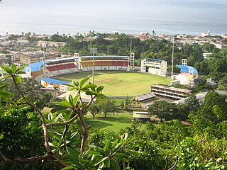
Windsor Park is a multi-purpose stadium in Roseau, Dominica. It serves as the national stadium and is used mostly for cricket matches. Other uses have included the World Creole Music Festival, the Finals of the Calypso Competition and the Miss Dominica pageant.

Portsmouth is the second largest town in Dominica, with 2,977 inhabitants. It lies on the Indian River on Dominica's northwest coast, in Saint John Parish. Cabrits National Park is located on a peninsula to the north of town. Portsmouth has its own sea port in Prince Rupert Bay.
Scotts Head is a village on the southwest coast of Dominica, in Saint Mark Parish. In 2001, its population was 721. Predominantly a fishing village, Scotts Head overlooks Soufrière Bay, which is protected as the Soufrière Scotts Head Marine Reserve. It is also a popular snorkeling and diving site for tourists.
Canefield is a town located on the west coast of Dominica, north of Roseau and south of Massacre, overlooking Pringle's Bay. The largest settlement in St. Paul Parish, it has a population of 2,803. It is home to an industrial estate with Harris Paints Dominica Ltd., a branch of the Jehovah's Witnesses, as well as the island's second airport. Neighbouring locales include Cochrane, Checkhall, Massacre and Fond Colé.

Calibishie is a Village in Dominica. It is located on the northeast coast of the island, immediately to the east of the village of Hampstead. The Calibishie Coast Travel Area is thought by many to be the most scenic and unspoiled region of Dominica. The Calibishie Coast is one of the few areas in the world where you can travel from the seashore to rain forest in little more than a mile. Calibishie is home to Dominica's Batibou, Hampstead, Hodges, Point Baptiste, Turtle and Woodford Hill Beaches.

Massacre is a town in Saint Paul Parish, Dominica, with about 1,200 inhabitants. It is located on the central west coast of the island, to the north of the capital, Roseau, on the Massacre River.

Dominica, officially the Commonwealth of Dominica, is an island country in the Caribbean. The capital, Roseau, is located on the western side of the island. It is geographically situated a part of the Leeward Islands chain in the Lesser Antilles archipelago in the Caribbean Sea. The island is located near Guadeloupe to the northwest and Martinique to the south-southeast. Its area is 750 km2 (290 sq mi), and the highest point is Morne Diablotins, at 1,447 m (4,747 ft) in elevation. The population was 71,293 at the 2011 census.

The Cathedral of Our Lady of Fair Haven of Roseau, originally known in French as Église de Notre-Dame du Bon Port du Mouillage de Roseau, is a Roman Catholic cathedral in Roseau, the capital city of Dominica in the Caribbean. The church is the see of the Diocese of Dominica, suffragan diocese of the Archdiocese of Castries, Saint Lucia.

Dominica Botanic Gardens is located on the Caribbean island-nation of Dominica, in the capital of Roseau. Once known as one of the finest botanical gardens in the region, it was severely damaged by Hurricane David in 1979. Following restoration efforts, it remains a focus of cultural life in Roseau, and a center of conservation research on Dominica.

The Invasion of Dominica was a successful French invasion of the island of Dominica in the British West Indies, during the American Revolutionary War. The action took place before British authorities in the Caribbean were aware that France had entered the war as an ally of the United States of America. The French governor in the West Indies, François Claude Amour, marquis de Bouillé, was notified on 17 August that France was at war, and organized the invasion, infiltrating spies to rally sympathetic French-speaking Dominican support.

Agostino Brunias was a London-based Italian painter from Rome. Strongly associated with West Indian art, he left England at the height of his career to chronicle Dominica and the neighboring islands of the West Indies. Painted in the tradition of vérité ethnographique, his art was as escapist as it was romantic.
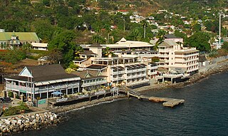
Fort Young Hotel is a hotel on the quayside of Roseau, Dominica, in the southern part of the capital next to Garraway Hotel, Dominica Museum, the Roseau Public Library, just south of the Governor's Residence and Roseau Cathedral. Located within the ramparts of the old colonial military Fort Young of 1770s vintage and built in the backdrop of a quay overlooking the Caribbean Sea, the 71-room hotel was established in 1964 and hosts a diving centre.
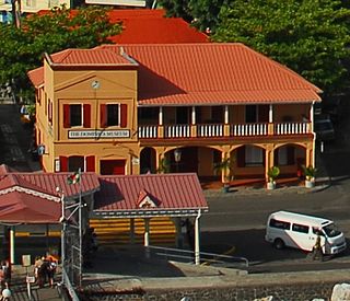
The Dominica Museum is the national museum of Dominica, an island nation in the Caribbean Lesser Antilles. It is located in the capital, Roseau, on a quay in front of the Old Market of Roseau, which was the centre for slave trading during colonial times. Its building was formerly an old market building and a post office dating to 1810.
Princess Margaret Hospital is the major trauma facility of Dominica, located in the northern Goodwill part of the capital, Roseau, to the northeast of Lindo Park, north of the Dominica Botanical Gardens, southwest of Clifton Dupigny Technical College and south of Stock Farm Prison. There are approximately 15 house/resident doctors and 12 specialists. The hospital has a four-bed Intensive Care unit. A hyperbaric chamber exists, but is not operational. The Ambulance service is operated by the Fire Department, with approximately six ambulances. Princess Margaret is the main hospital on the island with 800 beds. Most of the building is old, although the French have constructed a new wing to help develop the hospital.
Stock Farm Prison, also known as Her Majesty's Prison, is the national prison of the Caribbean island of Dominica. It lies in the northern part of the city of Roseau, in the Stock Farm neighborhood, just to the northwest of Dominica State College. As of 2010 it had a prison population of 289, up from 229 in 1992, which, given its size, is severely overcrowded. As of 2010 it was directed by Denis A. Blanc, under the Dominica Prison Service. A Department for International Development small grants scheme has enabled the Foreign and Commonwealth Office to launch a training programme in the prison for the convicts such as bricklaying, carpentry and plumbing to enhance their job prospects after being released.
Belles is a small village in the Caribbean island nation of Dominica. It is located at 15°27′12.7″N61°19′11.4″W and is a part of the country's St. Joseph administrative division. Its population is 500. Belles is a historical site for a few reasons. It is a major part of the highway system to the northern part of the island. The roads were blocked many years ago by Rastafarians who were not happy with the government. Many of them escaped to Jaco Flats and used it for refuge. This is a site that was used by the Maroons hundreds of years ago. As of 2016, the Esprit and Benjamin families own and control a majority of the private land.
References
- ↑ Golden, Fran Wenograd; Brown, Jerry (19 November 2004). Cruise Vacations for Dummies 2005. For Dummies. p. 282. ISBN 978-0-7645-6941-8 . Retrieved 25 June 2011.
- ↑ Showker, Kay (December 1991). Eastern Caribbean Ports of Call: From Puerto Rico to Aruba, Including the Panama Canal. Globe Pequot Press. p. 319. ISBN 978-0-87106-235-2 . Retrieved 25 June 2011.
- ↑ Kidder, Laura M. (7 September 1999). Fodor's 2000 Caribbean . Fodor's. ISBN 978-0-679-00314-4 . Retrieved 25 June 2011.
Coordinates: 15°17′48″N61°23′14″W / 15.29667°N 61.38722°W
| This Dominica-related article is a stub. You can help Wikipedia by expanding it. |
| This article about a market or bazaar is a stub. You can help Wikipedia by expanding it. |