Gipping is a village and civil parish in the Mid Suffolk district of Suffolk in eastern England. Located around three miles north north-east of Stowmarket, in 2005 its population was 80. At the 2011 Census the population remained less than 100 and was included in the civil parish of Old Newton with Dagworth.
Mid Suffolk is a local government district in Suffolk, England. The district is primarily a rural area, containing just three towns, being Stowmarket, Needham Market and Eye. Its council was based in Needham Market until 2017 when it moved to shared offices with neighbouring Babergh District Council in Ipswich, outside either district. In 2021 it had a population of 103,417.

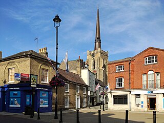
Needham Market is a town in the Mid Suffolk district of Suffolk, England. Nearby villages include Barking, Darmsden, Badley and Creeting St Mary. The town of Needham, Massachusetts, was named after Needham Market.

Gipping Rural District was a rural district in the county of East Suffolk, England. It was created in 1934 by the merger of the disbanded Bosmere and Claydon Rural District and the disbanded East Stow Rural District, under a County Review Order. It was named after the River Gipping and administered from Needham Market.
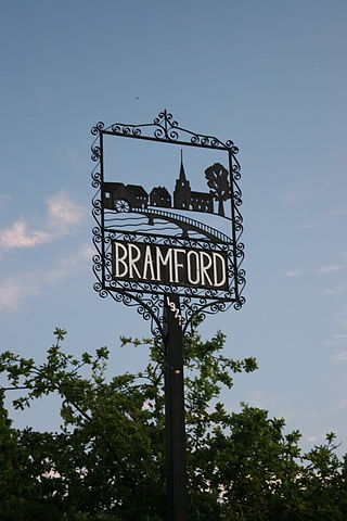
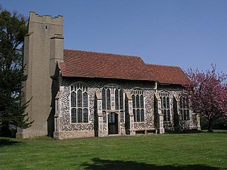
Bramford is a village in the Mid Suffolk district of Suffolk, England. It is three miles west of Ipswich of which it forms part of the wider Ipswich Built-up area. It was recorded in the Domesday Book as "Brunfort" or "Branfort". The River Gipping, runs at the bottom of the village and was a busy navigable waterway during the 19th century. A lock is still on the east of side of the village. The village has two churches; in the north west of the village on the B1067 road. Bramford railway station was originally on the Eastern Union Railway but closed in 1955.

Sproughton is a village in Suffolk, England, just to the west of Ipswich and is in the Babergh administrative district. It has a church, a primary school, a pub, a community shop and various groups. It is in the Belstead Brook electoral division of Suffolk County Council.

Barham is a village and civil parish in the Mid Suffolk district of Suffolk, England. The village is on the River Gipping. Surrounded by Great Blakenham, Baylham, Coddenham, Henley and Claydon, Barham is on the A14 road about six miles north of Ipswich. Barham has one pub - The Sorrel Horse - and is also known for the Gaps Fishing lakes, situated next to the Barham Picnic site on Pesthouse Lane.
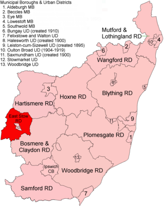
East Stow was a rural district in East Suffolk, England from 1894 to 1934.

Newton Flotman, meaning new farm or settlement, is a village and civil parish in the English county of Norfolk, lies about 7 miles south of Norwich on the A140 road between Tasburgh and Swainsthorpe. The River Tas flows through the village. The area of 4.87 km2 (1.88 sq mi) had 1,197 inhabitants in 497 households at the 2001 census, increasing to 1,489 at the 2011 census. For local government it lies in the district of South Norfolk.

Brettenham is a village and civil parish in the Babergh district of Suffolk, England. In 2005 it had a population of 270, increasing to 353 at the 2011 Census, and reduced to 320 in the 2021 census.

Newton, also known as Newton Green to distinguish it from Nowton near Bury St Edmunds, and Old Newton near Stowmarket, is a small village and civil parish in Suffolk, England. Part of Babergh district, it is located on the A134 between Sudbury and Colchester, around three miles from the former.

Worlington is a village and civil parish in the English county of Suffolk and in the old hundred of Lackford.
Copdock and Washbrook is a civil parish in the Babergh district in the county of Suffolk, England. It covers the villages of Copdock and Washbrook, as well as the hamlets of Coles Green, Mace Green and Washbrook Street.

Old Newton is a village in the civil parish of Old Newton with Dagworth, in the Mid Suffolk district of Suffolk, England. The village is situated around two miles north of Stowmarket, to the east of the junction of the Great Eastern Main Line and the Ipswich to Ely Line. Until the Beeching Axe it was served by Haughley railway station. In 2018 it had an estimated population of 809.

Little Blakenham is a village and civil parish in the Mid Suffolk district of Suffolk in eastern England. Located around two miles north-west of Ipswich and a mile south-west of its larger sister village Great Blakenham, in 2005 its population was 310. The parish also contains the hamlets of Inghams and The Common.

Little Whelnetham (well-NEE-thum) is a village and civil parish in the West Suffolk district of Suffolk in eastern England. Located around two miles south of Bury St Edmunds, in 2005 its population was 180.
Hawkedon is a village and civil parish in the West Suffolk district of Suffolk in eastern England. Located around 7 miles (11 km) south-south-west of Bury St Edmunds, the parish also contains the hamlet of Thurston End, and in 2005 had a population of 120. The majority of the village is classed as a conservation area.

Pettistree is a small village and a civil parish in the East Suffolk district, in the English county of Suffolk. According to the 2011 Census, Pettistree had a population of 194 people and is set in around 1,800 acres of farmland. The village has many footpaths and country lanes surrounding it. Being only one mile from the larger village of Wickham Market, Pettistree uses many of their resources; such as the Post Office, Medical and Resource Centre and Children's Play Area. The Primary School situated in Wickham Market also serves the younger children of Pettistree. However, senior children are required to travel 7 miles to Thomas Mills High School which is situated in Framlingham.

